Import a polygon from coordinates stored in text
This workflow demonstrates how to create a polygon feature class from coordinates stored as text.
Description
This workflow demonstrates how you can take coordinates that define a polygon stored in unstructured text, such as that stored in web pages, reports, emails, social media context or documents and create a polygon feature class. The first step is to convert the coordinates stored as text into a point feature class using the LocateXT Extract Locations pane and then convert the points to a polygon feature class using the Minimum Bounding Geometry geoprocessing tool.
Prerequisites
- To use the Extract Locations pane, a map must be active.
Tools and commands used
Steps
On the Data tab, in the Tools group, click Extract Locations drop-down and click Extract Locations
 .
.The Extract Locations pane appears.
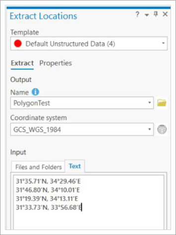
Type a Name for the new layer.
A new feature class will be created with this name in the project's default geodatabase.
Tip:
Alternatively, click Browse. In the dialog box, browse to a location for the new feature class. Type a Name and click Save.
Caution:
If you select an existing feature class instead of providing a name for a new feature class, a warning will appear in the Extract Locations pane. The existing feature class will be deleted and a new feature class with the same name will be created. Other maps may be affected.
Click the Coordinate System drop-down list or the Select coordinate system button
 and click the coordinate system you want to use for the output feature class.
Important:
By default, the coordinates found in the entered text are handled as if they were defined based on the GCS_WGS_1984 coordinate system. If you know the coordinates are based on a different coordinate system, you can change the coordinate system on the Coordinates tab. The locations that are found are transformed to the output feature class's coordinate system.
Click the Text tab and copy and paste the polygon coordinate text onto the tab.
Tip:
Extract Locations can extract locations from source files. Learn more in Extract locations from documents and text.
Click Extract.
The specified feature class is created and the coordinates are stored in the feature class as points. A feature layer referencing the feature class is added to the active map.
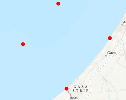
Now that points have been created, you must connect them together to create a polygon in a new polygon feature class.
On the Data tab, in the Tools group, click Binning drop-down and click Minimum Bounding Geometry
 .
.The Minimum Bounding Geometry tool opens in the Geoprocessing pane.
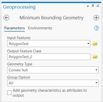
Click the Input Features parameter drop-down arrow and click the feature layer containing the points that were created by Extract Locations.
Tip:
Alternatively, update the name and location for the new polygon feature class in the Output Feature Class parameter.
Click the Geometry Type parameter drop-down arrow and click Convex hull.
Leave the remaining parameters set to the default values.
Click Run.
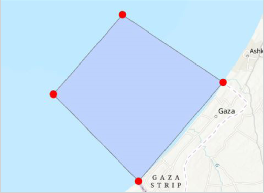
The new polygon feature class is created and added to your map.
Related topics
Alternate workflows
- There are alternative methods to create polygons from the points created by Extract Locations, see Create polygons from points in ArcGIS Pro