Validate a model
As you build a model, the data and tools you add and connect are automatically validated or checked to ensure that the data exists, is valid for use with a tool, and that all tool parameter settings are correctly specified. You can manually validate your model by clicking ModelBuilder > Run > Validate. This is typically only necessary after you have created a model and the data or tools in the model have been modified, moved, renamed, or deleted. You also need to validate your model if all processes in the model have been run and you want to run them again.
Validating a model will return all processes to their ready to run state. If you validate a model and a process changes to not ready to run (elements are gray), it means that one or more tool parameters or input variables are invalid.
Validate data variables
Data variables reference data paths and contain descriptive information about the data. When you validate a model, each data variable is checked to ensure that the data exists and can be used by the tools the variable is connected to. If any data variable references a data path that no longer exists, the variable becomes invalid, and the color changes to gray.
If the dataset changes in any way (for example, you add a new attribute field to a dataset outside of ModelBuilder), you may need to validate the model to see those changes. Similarly, if a dataset that is used as an input to a model is deleted or renamed, when you validate the model, it will invalidate the variable and change its color to gray. To repair this invalid data variable, double-click the variable, and select a new layer or browse to a new dataset.
Validate a tool
Each parameter of a geoprocessing tool automatically validates the data or value that is specified for that parameter. If the data or value is invalid, an error message appears. If a tool parameter is invalid, the geoprocessing tool and any downstream processes (tools that are dependent on or process the output of that tool) are marked as not ready to run, and their color changes to gray. To repair a tool that is not ready to run, double-click the tool to open it, find the parameter with the error, and specify a different dataset or value. You can also right-click any geoprocessing tool in a model, and select Messages to view the error messages.
Inspect a model
Inspect a model to identify potential issues in a model when additional diagnostics are needed. This process analyzes the entire model and reports issues and warnings. Model inspection can be used with any model and is particularly useful when working with older models, shared models, or models that may have been affected by changes to data, tools, scripts, licenses, or other resources.
Inspection can identify problems such as broken data connections, invalid or modified geoprocessing tools, missing data sources, Python script issues, licensing issues, and other model configuration problems.
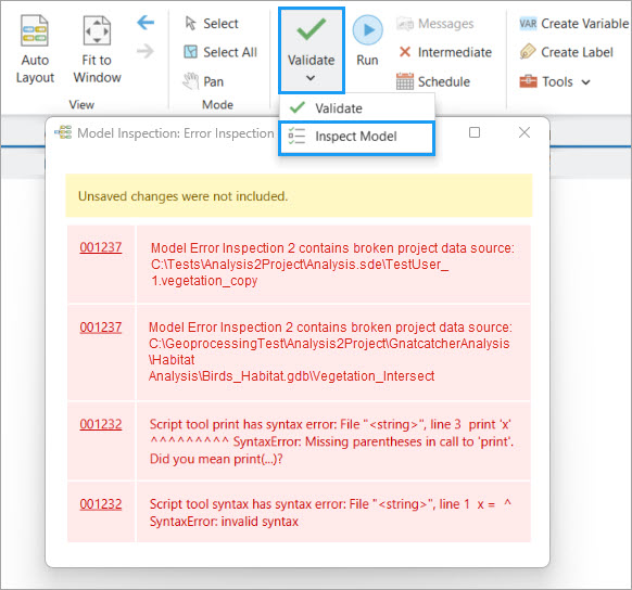
To inspect a model, on the ModelBuilder ribbon, click the Validate drop-down menu, and select Inspect Model.
Note:
Model inspection analyzes the last saved version of a model. Save the model before inspecting the model to ensure that any recent changes are included in the inspection results.
Detected issues are displayed in the Model Inspection window, which provides a view of the model's state. In many cases, you can identify the cause of a problem without examining individual model elements.
Unlike validation, model inspection does not change the state of model elements. Inspection reports issues, allowing you to review and assess potential problems without modifying the model. Model inspection complements validation by providing visibility into model issues and helping you troubleshoot models.