Basic linear referencing datasets
Basic linear referencing consists of two primary data types:
Route feature classes
Event tables
Dynamic segmentation uses events from event tables to locate and visually display these events along line features in a route feature class.
Route feature classes
A route feature class is a line feature class with a defined measurement system (such as distance or time). You can use these measurement values to locate events, assets, and conditions along linear features.
A route refers to any linear feature, such as a city street, highway, river, or pipe, with a unique identifier and a common measurement system along each linear feature.
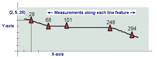
Feature vertices in route feature classes include m-values (x,y,m or x,y,z,m). These measured coordinates form the building blocks for route features. In route feature classes, line features have x,y (or x,y,z) coordinates that describe location, as well as a measurement (m) value along the line.
A collection of routes with a common measurement system is a route feature class. Each route in the feature class also has a unique identifier. Line features with the same unique identifier belong to the same route.
You can create and manage route feature classes as line feature classes in a geodatabase.
Route feature geometry
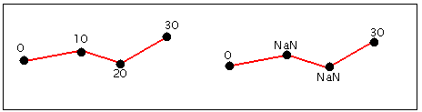
Route features have a measurement system stored with their geometry. Each measured line's segments have x-, y-, and m- (measure) or x-, y-, z-, and m-values. When a measure value is unknown for a particular vertex, its m-value is recorded as NaN (not a number), as illustrated in this example:
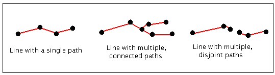
A line with one path represents a simple linear feature. A line with many paths represents a complex linear feature.
Although most applications use measures to represent increasing distances along a linear feature, measure values can arbitrarily increase, remain constant, or decrease along line features.
Measure values are independent of a feature class's horizontal coordinate system (and the vertical coordinate system as well if one is defined). This means measure values don't need to be in the same units as the feature class's x,y,z coordinates. For example, a feature class with a Universal Transverse Mercator (UTM) coordinate system, which uses meters, might store measure values in feet, miles, or time.
Event tables
Event tables contain information about assets, conditions, and events that you can locate along route features. Each row in the event table references an event and describes its location as measurements along named (identifiable) linear features.
There are two types of route events:
Point events—A point event, stored in a point event table, describes a discrete location along a route (a point) and uses a single measure value to describe this location—for example, Mile 3.2 on I-91.
Line events—A line event, stored in a line event table, describes a portion of a route (a line) and uses both from- and to- measure values to describe this portion of a route—for example, Mile 2 to Mile 4 on I-91.
All event tables must contain a route identifier field and one or more measure fields. A point event table uses a single measure field to describe its location. A line event table requires two measure fields (start measure and end measure) to describe its location.
Event tables typically store route locations and their associated attributes based on a common theme. For example, four event tables containing information on speed limits, year of resurfacing, present condition, and accidents can dynamically locate events on one route feature class.
An event table can be any tabular data source that ArcGIS Pro supports. This includes geodatabase tables, delimited text files, dBASE, and database management system (DBMS) tables.
Event table example
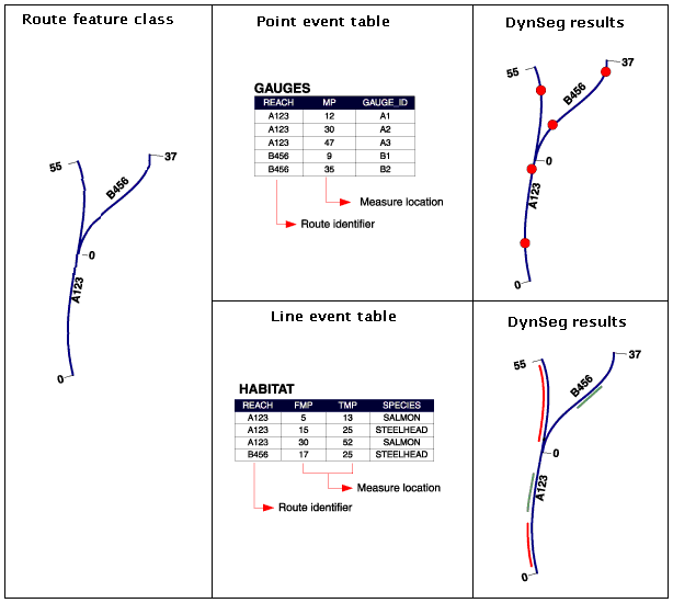
Hydrologists and ecologists use linear referencing on stream networks to locate various types of events, as illustrated in the following example. The route feature class for streams provides measures along the streams using river reach mile. Point and line event tables record the route ID and location along each river reach.
Storing features using relative locations
With linear referencing, you refer to locations along linear features in terms of their route measure, or distance from a known point. For example, it often makes sense to describe the location of an accident as occurring at 12 miles from the beginning of the interstate rather than at a GPS coordinate such as 1,659,060.25, 1,525,238.97.
To determine a location along a linear feature, you need a system of measurement. When a linear feature stores a measurement system, you can express any location along it in terms of the measure values.

In addition to making data more intuitive, storing data as a relative location along a linear feature ensures that spatial phenomena known to fall on the feature are located on it. For example, without an accurate basemap, locating accidents using x,y coordinates might place them off the road network. Linear referencing avoids this problem because it locates accidents relative to the linear feature.