Curves
 Available with the Linear Referencing license.
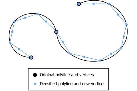
ArcGIS Linear Referencing supports curves by densifying curved centerlines into polylines to preserve shape and to build routes within an LRS Network. When you create a centerline with a curve in an edit session, ArcGIS Linear Referencing automatically converts the curve into a densified polyline.
Note:
Densification does not affect the start and end vertices of a curved centerline. Densification affects only the intermediate vertices between the start and end of a curved centerline.
After densification, the
Shape_Lengthattribute of the densified centerline may shorten slightly. This is expected because the densification process adjusts the curve within a tolerance to create a near-identical shape.
Densification method
When you create or modify a centerline to contain curves, they are automatically densified using the maxDeviation formula. The maxDeviation formula determines the maximum distance a newly placed vertex on a densified polyline can deviate from the original location of the curve.
The maxDeviation formula is 2 * (XY Resolution) * 100.
Note:
The densification process runs automatically in the background and does not support user interaction.
Auto-densification example
In the following example, a curve has a length of 1,000 meters and an x,y resolution of 0.0001 meters.
After a centerline edit session, maxDeviation densifies the curve. This is 2 * 0.0001 * 100, with a result of 0.02. This factor creates vertices at defined intervals along the curve to create a segmented section where the curve previously existed. After this value is calculated, the process densifies the curve into a line feature with 94 vertices.