Multipatch Footprint (3D Analyst Tools)
Summary
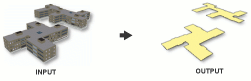
Creates polygon footprints representing the two-dimensional area of multipatch features.
Illustration
Usage
The output footprint will have the same fields as the input feature, along with the following fields:
Z_Min—The smallest z-value from the multipatch feature.Z_Max—The largest z-value from the multipatch feature.
Use the Group Field parameter if a structure comprises multiple features that share a common identifier in the attribute table.
Input multipatch features that have no 2D area, such as a vertical walls modeled using vertical faces, will result in 2D extent boxes rather than their true 2D footprint since the footprint more closely resembles a line than a polygon.
Parameters
| Label | Explanation | Data type |
|---|---|---|
|
Input Feature Class |
The multipatch feature whose footprint will be generated. |
Feature Layer |
|
Output Feature Class |
The resulting footprint polygon feature class. |
Feature Class |
|
Group Field (Optional) |
The field that will be used for combining multipatch features so that they contribute to the same footprint polygon. |
Field |
Environments
Current Workspace, Extent, Output Coordinate System, Geographic Transformations, XY Resolution, XY Tolerance, Output CONFIG Keyword, Auto Commit
Licensing information
- Basic: Yes
- Standard: Yes
- Advanced: Yes