Convert Marker Placement To Points (Cartography Tools)
Summary
Creates points from the markers of a marker placement in a symbolized polygon feature.
Illustration
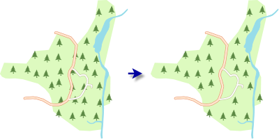
Usage
This tool assesses graphic conflicts of symbolized features to determine which markers will be included in the output. The symbology extent and the reference scale are both used. Run this tool only after you finalize the appearance of the symbols and ensure that the reference scale corresponds to the final intended output scale.
The default coordinate system of the output is the same as the current map view. To use a different coordinate system, use the Cartographic Coordinate System environment setting. When the tool is run in a scripting environment without an active map, the coordinate system of the input features will be used.
Only Single Symbol and Unique Values symbology are supported on the input layer. Attribute mapping settings saved in the input layer will be honored.
When the Keep At Least One Marker parameter is specified, a log file will be created that lists the input features for which a single marker was created that would otherwise have been omitted. The location of the log file is included in the geoprocessing message details.
Points will be created for every supported marker layer in an input symbol. To ensure that complex, multilayer markers are treated as a single entity and created as a single point in the output, first create the symbol as a point symbol and save it to a style. Then, on the Layers tab in the Symbology pane, use the Style button in the Appearance settings to set the marker symbol from the style.
The Displacement Method and Minimum Marker Distance parameters are available when at least one marker layer uses a random placement. Use these parameters to resolve conflicts between overlapping markers and to preserve a minimum distance between them. The Displace apart option will move markers away from each other until they reach the minimum distance and will remove markers if necessary to avoid conflicts. The Displace toward grid option will move markers until they either reach the minimum distance apart or reach their original grid placement. No markers will be removed with the Displace toward grid option.
Parameters
| Label | Explanation | Data type |
|---|---|---|
|
Input Layer |
A polygon layer symbolized with a marker placement. |
Layer |
|
Output Feature Class |
A point feature class containing points created from markers in the input layer's marker placement settings. The points will be added to the active map as a layer symbolized with a unique value renderer using symbols from the input. |
Feature Class |
|
Create Multipoints (Optional) |
Specifies whether output point features will be multipoint.
|
Boolean |
|
Boundary Option (Optional) |
Specifies whether output points will be created for input markers that cross polygon boundaries.
|
String |
|
Boundary Distance (Optional) |
The minimum distance between the output point symbols and the polygon boundaries. This parameter is applied only when the Boundary Option parameter is set to Fixed distance. The default value is 0. |
Double |
|
Boundary Distance Field (Optional) |
A numeric field from the input polygons that will be used to determine the boundary distance. This parameter is applied only when the Boundary Option parameter is set to Value from field. |
Field |
|
Boundary Distance Unit (Optional) |
Specifies the linear unit that will be used for boundary distance values.
|
String |
|
Input Barrier Layers (Optional) |
The layers containing points, lines, or polygon features that are conflict barriers for input markers. Markers that conflict with barriers will not be created. The symbology of the barrier layers will be considered. Value table columns:
|
Value Table |
|
Keep At Least One Marker (Optional) |
Specifies whether a single marker will be created for input polygons when all markers conflict with boundaries or barriers.
|
Boolean |
|
Displacement Method (Optional) |
Specifies the displacement method that will be used to move markers that are too close to each other. This parameter is applied only when markers are positioned randomly inside the polygons.
|
String |
|
Minimum Marker Distance (Optional) |
The minimum distance between individual markers. This parameter is applied only when markers are positioned randomly inside the polygons. The default value is 0. |
Linear Unit |
Environments
Cartographic Coordinate System, Reference Scale
Licensing information
- Basic: No
- Standard: No
- Advanced: Yes