Extract Scanned Polygons (Conversion Tools)
Summary
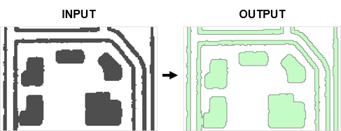
Generates polygon features from scanned images.
Illustration
Usage
The raster must be classified into two classes (binary image) in order to extract features.
Results may be determined by the state of the scanned map at the time of the extraction. To eliminate noise and unwanted pixels it is sometimes necessary to modify the image prior to the extraction of features.
The parameters control which cells are extracted as well as the amount of generalization and smoothing that is applied to the output polygon features.
Parameters
| Label | Explanation | Data type |
|---|---|---|
|
Input Scanned Map Image |
The input raster dataset. The raster must be classified into two classes (binary image). |
Raster Layer |
|
Foreground Value |
The foreground value that represents the raster cells that will be extracted to line features. |
Long |
|
Output Polygon Features |
The output feature class that will contain the converted polygons that represent the outline of the raster cells. |
Feature Class |
|
Compression Tolerance (Optional) |
Simplifies lines by removing vertices based on the specified tolerance. Higher compression tolerance values will result in fewer vertices and greater deviation from the original line shape. The compression tolerance indicates the degree of generalization, not map or pixel units. |
Double |
|
Apply Smoothing (Optional) |
Specifies whether smoothing will be applied to polygon features during extraction.
|
Boolean |
|
Smoothing Weight (Optional) |
The intensity of smoothing. Higher smoothing weight values produce smoother lines but may cause the output to deviate from the original shape. The smoothing weight value is not a specific map or pixel unit. |
Double |
|
Hole Size (Optional) |
If a hole's diagonal length is less than or equal to the specified distance, it will be treated as part of the raster line when extracted. This parameter allows you to ignore holes (small gaps fully enclosed by foreground pixels) in raster lines during extraction. Holes often result from poor source quality or scanning errors. |
Long |
Environments
Current Workspace, Extent, Output Coordinate System, Geographic Transformations, Output CONFIG Keyword, Output XY Domain, Output Z Domain
Licensing information
- Basic: No
- Standard: No
- Advanced: Yes