Export Territory Solution (Territory Design Tools)
Summary
Exports a territory solution to a feature class. The export includes records from all levels (hierarchy) of the solution.
Usage
A single feature class will be created with all levels.
The default value for the Output Shape Type parameter is set to the primary feature class type—for example, Boundary.
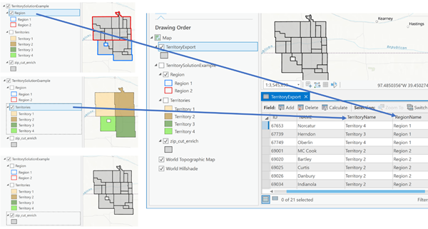
The following screen capture illustrates an example of three levels (three feature classes)—Base, Territory, and Region—exported into a single feature class. Geometry from base level and attributes of each base feature determine the territory or region to which it belongs.
Parameters
| Label | Explanation | Data type |
|---|---|---|
|
Input Territory Solution |
The Territory Design solution layer that will be exported. |
Group Layer; Feature Dataset; String |
|
Output Feature Class |
The feature class that will contain the exported territory solution. |
Feature Class |
|
Output Shape Type (Optional) |
Specifies the feature geometry type to export.
|
String |
Environments
Licensing information
- Basic: Requires Business Analyst
- Standard: Requires Business Analyst
- Advanced: Requires Business Analyst