Mission
Note:
ArcGIS Reality Web App is a beta feature at ArcGIS Enterprise 12.2. While in beta, this capability may not be feature complete and, as such, may have known performance or quality issues and will not be supported by Esri Technical Support.
Feedback on this feature can be provided through the Esri Early Adopter Community.
A mission is a container for managing all related imagery, processing, and the resulting products of a single data capture session. All the missions of a project are shown on the missions tab of the project page.
Missions page components
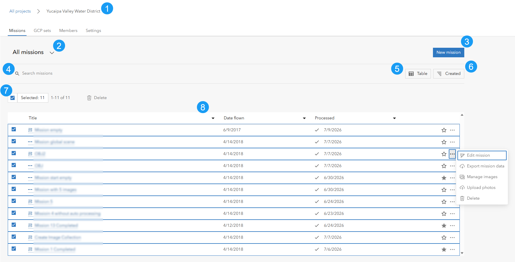
The missions page contains the following elements:
Project Breadcrumb Navigation: Displays the current project location and provides navigation back to the Projects page. Users can click All Projects to return to the Projects page.
Mission Filter Dropdown: To filter the missions to show. Available options are all missions and favorite missions. By default, all missions are displayed.
New mission button: To create a new mission within the current project.
Search Box: Searches missions within the current project by title or tags.
View Selector: To control how missions are displayed. Available options are table or grid. Missions are listed in table format by default.
Sort Button: To control the sorting category and order of the missions. Available options include created date, update date, and title. By default, missions are sorted chronologically by created date.
Mission Selection Controls: To select or deselect multiple missions and perform bulk actions on selected missions. The selected mission count and available actions are also displayed here. The only bulk action that can be performed on missions is delete.
Mission List: Display all missions belonging to the mission in the selected view format. Each card in a grid view or row in a table view represents a mission with various elements including selection check box, mission title, flown date, processed date, favorite control ☆, and action menu ... for additional mission operations. Clicking the mission title opens the mission.
Additional mission operations
The action menu ... provides access to addition mission operations such as
Edit Mission: Modify mission title, mission type and flown date. The mission type can be one of area survey, corridor, crosshatch survey, inspection, panorama, perimeter scan, vertical scan or others selected during mission creation. The default flown date is derived from the metadata of the uploaded source images.
Export Mission: Download source imagery, products and other files of the mission.
Manage images: View, add or remove source images of the images.
Upload photos: Add additional drone images to the mission.
Delete: Permanently remove the mission and its associated data.