Get started with ArcGIS Reality Server
Note:
ArcGIS Reality Server is a beta feature at ArcGIS Enterprise 12.1. While in beta, this capability may not be feature complete and, as such, may have known performance or quality issues and will not be supported by Esri Technical Support.
Feedback on this feature can be provided in the ArcGIS Enterprise 12.1 Beta Features Early Adopter Community.
You can use ArcGIS Reality Server tools in ArcGIS Pro to define reality mapping processing to be applied on a server. Automation and customization are also possible through ArcGIS API for Python and ArcGIS REST API.
Use ArcGIS Pro as a client for Reality Server
ArcGIS Pro provides a comprehensive workspace for reality mapping for drone, digital aerial, and satellite images. If ArcGIS Pro is connected to an ArcGIS Enterprise site configured with Reality Server, image adjustment and 2D and 3D product generation can be processed on the server. Products generated are automatically shared as imagery layers (True Ortho/DTM/DSM), scene layers (3D mesh), or point cloud layers (3D Point Cloud) on the portal.
Note:
ArcGIS Pro requires a Standard or Advanced license to be used as a client for Reality Server.
Complete the following steps to use ArcGIS Pro as client for drone, digital aerial, or satellite data processing:
Add an ArcGIS Enterprise site configured with Reality Server and set it as an active portal in ArcGIS Pro.
See the Manage portal connection from ArcGIS Pro tutorial for more details.
Create a Reality mapping workspace to be processed on the server.
On the Imagery tab, click the New Workspace drop-down menu and choose New workspace.
In the Workspace Configuration window, provide a name for the workspace and specify other settings accordingly.
Check the Process this image collection on server box.
You won't see this option if your active portal connection is not an ArcGIS Enterprise site configured with Reality Server.
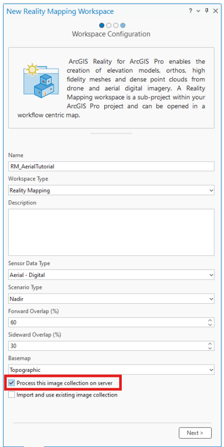
Accept other default settings and click Next until you finish creating the Reality mapping workspace.
See the Create or import a Reality mapping workspace tutorial for more details.
Perform an adjustment.
Generate Reality mapping products.
See the following detailed tutorials for each sensor workflow:
Create drone imagery products in ArcGIS Pro using Reality Server
Create 2D digital aerial imagery products in ArcGIS Pro using Reality Server
Create 3D digital aerial imagery products in ArcGIS Pro using Reality Server
Create a digital surface model product from satellite imagery in ArcGIS Pro using Reality Server
Automate Reality mapping workflows using ArcGIS API for Python
ArcGIS API for Python provides a modern Pythonic library for automating reality mapping tasks. The following are sample notebooks for various sensor workflows: