VfInverseLinear
サマリー
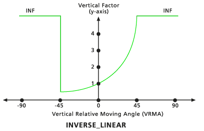
Defines the relationship between the vertical cost factor and the vertical relative moving angle through an inverse linear function.
ディスカッション
This object is used in the Distance Accumulation and Distance Allocation Spatial Analyst tools, as well as the Path Distance, Path Distance Allocation, and Path Distance Back Link Legacy Distance tools.
The vertical factor (VF) object defines the relationship between the vertical cost factor and the vertical relative moving angle (VRMA).
VF defines the vertical difficulty encountered in moving from one cell to the next.
VRMA identifies the slope angle between the FROM or processing cell and the TO cell.
The VFs are determined by the inverse values from a straight line in the VRMA-VF coordinate system. The line intercepts the y-axis, equitable to the VF factor, the value associated with the zeroFactor. The slope of the line can be identified if specified with the slope argument.
構文
VfInverseLinear({zeroFactor}, {lowCutAngle}, {highCutAngle}, {slope})
| 名前 | 説明 | データ タイプ |
|---|---|---|
|
zeroFactor (オプション) |
The The default value is 1.0. |
Double |
|
lowCutAngle (オプション) |
The VRMA degree defining the lower threshold, below which (less than) the VFs are set to infinity. The default value is -45.0. |
Double |
|
highCutAngle (オプション) |
The VRMA degree defining the upper threshold, beyond which (larger than) the VFs are set to infinity. The default value is 45.0. |
Double |
|
slope (オプション) |
Identifies the slope of the straight line in the VRMA-VF coordinate system. Slope is specified as the rise/run. For example, a 30-degree slope is 1/30, specified as 0.03333 (rise/run: 1 VF on the y axis / 30 degrees on the x axis); a -45-degree slope as -0.02222. The default value is -0.022222. |
Double |
プロパティ
| 名前 | 説明 | データ タイプ |
|---|---|---|
|
zeroFactor (読み取り/書き込み) |
The |
Double |
|
lowCutAngle (読み取り/書き込み) |
The VRMA degree defining the lower threshold, below which (less than) the VFs are set to infinity. |
Double |
|
highCutAngle (読み取り/書き込み) |
The VRMA degree defining the upper threshold, beyond which (larger than) the VFs are set to infinity. |
Double |
|
slope (読み取り/書き込み) |
Identifies the slope of the straight line in the VRMA-VF coordinate system. Slope is specified as the rise over the run. For example, a 30-degree slope is 1/30, specified as 0.03333 (rise/run: 1 VF on the y axis / 30 degrees on the x axis); a 90-degree slope as 0.011111. |
Double |
コードのサンプル
Demonstrates how to create a VfInverseLinear class and use it in the DistanceAccumulation tool within the Python window.
import arcpy
from arcpy import env
from arcpy.sa import *
env.workspace = "C:/sapyexamples/data"
myVerticalFactor = VfInverseLinear(1.0, -45, 45, -0.02222)
outDistAccum = DistanceAccumulation("Source.shp", "", "elev.tif",
                                   "cost.tif", "elev.tif",
                                    myVerticalFactor)
outDistAccum.save("C:/sapyexamples/output/distAccumVfIL.tif")
Performs a distance accumulation analysis using the VfInverseLinear class.
# Name: VfInverseLinear_Ex_02.py
# Description: Uses the VfInverseLinear object to run the
#              DistanceAccumulation tool
# Requirements: Spatial Analyst extension

# Import system modules
import arcpy
from arcpy import env
from arcpy.sa import *

# Set environment settings
env.workspace = "C:/sapyexamples/data"

# Set local variables
inSourceData = "source.shp"
inCostRaster = "costraster.tif"
inElevation = "elev.tif"

# Create the VfInverseLinear Object
zeroFactor = 1.0
lowCutAngle = -45
highCutAngle = 45
slope = -0.02222
myVerticalFactor = VfInverseLinear(zeroFactor, lowCutAngle, highCutAngle,
                                    slope)

# Run PathDistance
outDistAccum = DistanceAccumulation(inSourceData, "", inElevation,
                                    inCostRaster, inElevation,
                                    myVerticalFactor)

# Save the output
outDistAccum.save("C:/sapyexamples/output/distaccumvfIL2.tif")