Apportionment in standard demographics
Esri apportions standard demographics sourced from Michael Bauer Research GmbH to the lowest level of geography in every country or region. There are some exceptions to this method, such as Germany, where demographic data is apportioned to Postcodes instead of Municipalities
Key terms
Block (settlement point) apportionment uses demographic data from small geographic units (such as statistical areas or subdistricts) to calculate demographic data for larger geographic areas (such as districts), based on the population weights of the small areas. By considering where people actually live within the smaller areas, this apportionment method can provide demographic approximations for larger areas.
Centroid in polygon aggregation—A centroid is a point that represents the geometric center of a geographic region (a polygon). In data enrichment, centroids are used to summarize demographic data (such as Total Population or Total Households) for a region.
Threshold areas are the maximum permitted study area sizes (150, 250, or 400 kilometers) used to select the appropriate data aggregation method.
Country diameter—The apportionment algorithm converts each country or region's nonuniform total feature area into a standardized country diameter in kilometers, which is used in the aggregation schema.
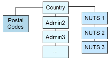
Geography levels—Some countries have multiple geography level hierarchies, such as one for postal codes and one for administrative levels (or the recently added NUTS boundaries in Europe). These are nested separately rather than sequentially.
Note:
See the Data enrichment and Data apportionment topics to learn more.
Each country or region topic lists the available levels of geography for that region in a Geography levels table. Geography levels are ordered from highest to lowest based on feature count, regardless of hierarchy.
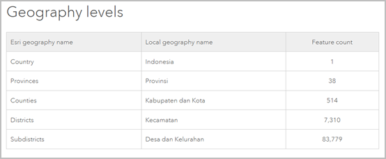
Data apportionment uses the lowest geography level in every country or region. When there are multiple geographic hierarchies, the lowest level in each hierarchy is considered during data enrichment.
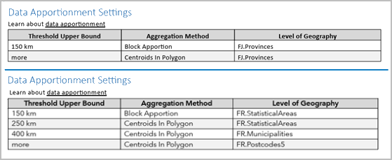
The apportionment method (also called aggregation) is shown in the Release notes PDF in a Data Apportionment Settings table.
Aggregation schema
The algorithm assigns aggregation methods to countries by threshold areas as follows:
Block (or settlement point) apportionment is always used for the lowest eligible geography level with an upper threshold area of 150 kilometers unless an exception is noted.
Centroids in polygon aggregation is typically applied to the lowest or next lowest geography level (up to three levels) with trade area thresholds ranging from above 150 kilometers, 150-250 kilometers, above 250 kilometers, 250-400 kilometers, to above 400 kilometers. Final threshold area limits are labeled more in the Data Apportionment Settings table. The aggregation schema determines which method to use based on criteria such as the country diameter, the total number of geography levels and geographic hierarchies, the overall feature count of each geography level, and so on.