Introduction to ArcGIS Pipeline Referencing
![]() Available with Location Referencing license.
Available with Location Referencing license.
ArcGIS Pipeline Referencing is an ArcGIS Server extension that provides the capability to publish linear referencing system (LRS) networks and registered event layers as a map service.
LRS data is published to an ArcGIS Enterprise deployment as a map service.
Note:
LRS data can also be published to ArcGIS Online. However, the Linear Referencing capability is not available in ArcGIS Online.
Networks and events can be accessed by any client app that can consume an ArcGIS Server map service, including existing web and mobile clients. Additionally, web developers can use the REST APIs to develop web and connected mobile apps for their LRS data.
Linear Referencing capability in map services
Pipeline Referencing extends an existing map service with an additional REST service capability for linear referencing when a map is published with the Linear Referencing capability enabled.
Map services with the Linear Referencing capability enabled support the following:
Provide LRS-based network and event layer information.
Translate coordinate locations to routes and measures.
Translate (locate) routes and measures to coordinates or polylines.
Validate route and measure values.
Convert measures between linear referencing methods (LRMs).
Multilayer, transactional event editing, with support for overlap retirement and coincident event merging.
Pipeline Referencing provides online developer help for the REST services made available by the Linear Referencing capability.
Learn more about the Linear Referencing Service REST API
Included JavaScript web developer samples
Pipeline Referencing includes ArcGIS Pipeline Referencing sample web apps that demonstrate the use of available REST services.
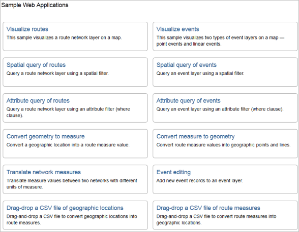
These developer samples demonstrate how a web or connected mobile developer can accomplish the following:
Visualize networks on a map.
Visualize events on a map.
Locate measures on a route.
Perform spatial and attribute queries for routes.
Perform spatial, measure, and attribute queries for events.
Convert routes and measures to coordinates.
Convert coordinates to routes and measures.
Convert measures between LRMs.
Web-based event data editing
ArcGIS Experience Builder is available through ArcGIS Enterprise and supports the editing of event data in a web browser using Location Referencing widgets.
Learn more about using Experience Builder and deploying Location Referencing widgets
Platform for reporting
Pipeline Referencing spatially enables event data from non-GIS systems and integrates it through the LRS. Pipeline Referencing, together with ArcGIS, can be used to produce data products and maps to support reporting on length calculations of pipeline characteristics, safety analysis, and other analyses of pipeline data. These reports and data products provide business units within your organization transparency into many facets of pipeline data, such as pipeline assets, incidents, inspections, and pipe characteristics.