Synthetic aperture radar raster types
There are many synthetic aperture radar (SAR) sensor types available, and each has various product types and polarizations. Through active sensing, SAR satellites function day and night.
Currently, only SAR data processed using the backprojection method for image formation is supported.
Capella
Capella is a high-resolution SAR commercial microsatellite constellation. The X-band sensor operates at a center frequency of 9.65 GHz (wavelength of approximately 3.1 centimeters). The satellites collect data in three modes: Stripmap (SM), Sliding Spotlight (SS), and Spotlight (SP), with coverage of up to 20 kilometers and resolution as fine as 0.5 meters. All three modes include a single polarization (HH or VV) product.
|
Polarization |
Band |
Wavelength (cm) |
|---|---|---|
|
HH |
X |
3.1 |
|
VV |
X |
3.1 |
Product types
The Capella Geocoded Ellipsoid Corrected (GEC), Geocoded Terrain Corrected (GEO), and Sensor Independent Complex Data (SICD) products are supported.
GEC—These products are images that have been multilooked, projected to ground range using an Earth ellipsoid model, and orthorectified using a range-Doppler approach and the average scene center height. A GEC image is stored as a real value array. The value in each pixel represents the amplitude of the reflected backscatter signal. GEC products contain approximately square resolution pixels and square pixel spacing.
GEO—These products are images that have been multilooked, projected to ground range using a digital elevation model (DEM), and orthorectified using a range-Doppler approach and a DEM. A GEO image is stored as a real value array. The value in each pixel represents the amplitude of the reflected backscatter signal. GEO products contain approximately square resolution pixels and square pixel spacing.
SICD—These products are Single Look Complex (SLC), images in the slant range. An SLC image is stored as a complex value array. The single complex value in each pixel represents the amplitude and phase of the reflected backscatter signal.
Processing templates
The following processing templates are available:
Stripmap—Only Stripmap mode data will be processed.
Sliding Spotlight—Only Sliding Spotlight mode data will be processed.
Spotlight—Only Spotlight mode data will be processed.
Note:
Capella Spotlight mode SLC and SICD products have switched to a Polar Format Algorithm (PFA) processor, which is not currently supported. This transition occurred approximately April 2024. SAR data that is processed using the backprojection method is still supported.
The following polarizations are available:
HH—The radar signals are transmitted horizontally and received horizontally.
VV—The radar signals are transmitted vertically and received vertically.
Raster product support
The raster product is in the Capella product directory, where the .json file represents the raster product container.

Expanding the .json file shows the raster products by the available mode. Both the raster container and raster products can be loaded into ArcGIS Pro. Since Capella data has a single polarization, the raster product is loaded as a single-band raster.

To learn more about Capella, visit the Capella Space website.
ICEYE
ICEYE is a high-resolution SAR commercial microsatellite constellation. The X-band sensor operates at a center frequency of 9.65 GHz (wavelength of approximately 3.1 centimeters). The satellites collect data in three modes: Stripmap (SM), Spotlight (SL), and Scan (SC), with coverage of up to 100 kilometers and resolution as fine as 1 meter. All three modes include a single polarization (VV) product.
|
Polarization |
Band |
Wavelength (cm) |
|---|---|---|
|
VV |
X |
3.1 |
Product types
The ICEYE Ground Range Detected (GRD) and Sensor Independent Complex Data (SICD) products are supported.
GRD—These products are images that have been multilooked and projected to ground range using an Earth ellipsoid model. A GRD image is stored as a real value array. The value in each pixel represents the amplitude of the reflected backscatter signal. GRD products contain approximately square resolution pixels and square pixel spacing.
SICD—These products are Single Look Complex (SLC), images in the slant range. An SLC image is stored as a complex value array. The single complex value in each pixel represents the amplitude and phase of the reflected backscatter signal.
Processing templates
The following processing templates are available:
Scan—Only Scan mode data will be processed.
Stripmap—Only Stripmap mode data will be processed.
Spotlight Extended Area—Only Spotlight Extended Area mode data will be processed.
Spotlight High—Only Spotlight High mode data will be processed.
The VV polarization is available with ICEYE products. With this polarization, the radar signals are transmitted vertically and received vertically.
Raster product support
The raster product is in the ICEYE product directory, where the .xml file represents the raster product container.

Expanding the .xml file shows the raster products by the available mode. Both the raster container and raster product can be loaded into ArcGIS Pro. Since ICEYE data has a single polarization, the raster product is loaded as a single-band raster.

To learn more about ICEYE, visit the ICEYE website.
NISAR
NISAR a is NASA and ISRO joint synthetic aperture radar (SAR) mission, which uses a dual frequency radar system. The L-band sensor operates over a range from 1.219 GHz to 1.296 GHz and is equipped to acquire data in the frequency A and frequency B groups. The S-band sensor operates at a central frequency of 3.2 GHz (wavelength of approximately 9.4 centimeters). The satellite collects data in SweepSAR mode with coverage of more than 240 kilometers and resolution as fine as 3 meters. SweepSAR mode offers a single polarization (HH or VV), dual polarization (HH+HV or VV+VH), compact polarization (RH+RV), and quad polarization (HH+HV+VH+VV) products.
|
Polarization |
Bands |
Wavelength (cm) |
|---|---|---|
|
HH |
L and S |
24 and 9.4 |
|
HV |
L and S |
24 and 9.4 |
|
VH |
L and S |
24 and 9.4 |
|
VV |
L and S |
24 and 9.4 |
|
RH |
L and S |
24 and 9.4 |
|
RV |
L and S |
24 and 9.4 |
The following polarization configurations are available:
HH—The radar signal is transmitted horizontally and received horizontally.
HV—The radar signal is transmitted horizontally and received vertically.
VH—The radar signal is transmitted vertically and received horizontally.
VV—The radar signal is transmitted vertically and received vertically.
RH—The radar signal is transmitted right circularly and received horizontally.
RV—The radar signal is transmitted right circularly and received vertically.
HH HV—Dual HH+HV polarization.
VV VH—Dual VV+VH polarization.
RH RV—Dual Compact polarization.
HH VV HV VH—Quad polarization.
Product Types
The Geocoded Polarimetric Covariance (GCOV) product is supported.
- GCOV—These products are images that have been radiometrically terrain corrected and projected to the ground range using an area projection algorithm. This ground range projection is either a predefined Universal Transverse Mercator (UTM) or polar stereographic projection system grid. A GCOV product contains multiple images representing the real and complex covariance matrix terms. The diagonal terms of the covariance matrix are real-values and represent the intensity of the radar backscatter for each polarization. The cross covariance terms of the covariance matrix are complex-valued and describe the cross covariance between different polarizations. Depending on the GCOV processing mode, the cross covariance terms may not always be available.
The table below shows a matrix of the possible polarizations available in NISAR GCOV products.
| Received Polarizations | |||||||||
|---|---|---|---|---|---|---|---|---|---|
| HH | HV | VH | VV | RH | RV | ||||
| Transmitted Polarizations |
|||||||||
| HH | HHHH | HHHV | HHVH | HHVV | |||||
| HV | HVHV | HVVH | HVVV | ||||||
| VH | VHVH | VHVV | |||||||
| VV | VVVV | ||||||||
| RH | RHRH | RHRV | |||||||
| RV | RVRV | ||||||||
The diagonal terms (HHHH, HVHV, VVVV, VHVH, RHRH, and RVRV) represent the intensity of the radar backscatter. The cross covariance terms (HHHV, HHVH, HHVV, HVVH, HVVV, VHVV, and RHRV) describe the intensity and phase between different polarizations.
Processing templates
The following processing templates are available in GCOV product. The cross covariance templates are only included for quad-polarization GCOV products.
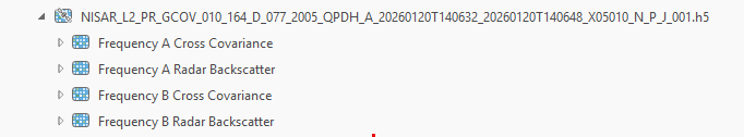
Frequency A Radar Backscatter—Only diagonal terms of the covariance matrix from Frequency A will be added.
Frequency A Cross Covariance—Only the cross covariance terms of the covariance matrix from Frequency A will be added.
Frequency B Radar Backscatter—Only diagonal terms of the covariance matrix from Frequency B will be added.
Frequency B Cross Covariance—Only the cross covariance terms of the covariance matrix from Frequency B will be added.
Raster Product Support
The raster product is in the NISAR product directory, where the .h5 files represent the raster product container.
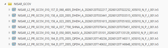
Expanding the .h5 file shows the raster products by the frequency type of data, which can be loaded into ArcGIS Pro. The available polarizations are represented as bands in the raster product.
To learn more about NISAR, refer to the NISAR website.
PAZ
PAZ is a SAR commercial satellite operated by Hisdesat. It is an X-band SAR satellite in a sun-synchronous orbit, operating at a center frequency of 9.65GHz (wavelength of approximately 3.1 centimeters). The satellite collects data in six modes with coverage of up to 270 kilometers and resolutions as fine as 25 centimeters. Various modes of PAZ offer single polarization (HH or VV), and dual polarization (HH+HV or VV+VH or HH+VV).
|
Polarization |
Band |
Wavelength (cm) |
|---|---|---|
|
HH |
X |
3.1 |
|
VV |
X |
3.1 |
|
HV |
X |
3.1 |
|
VH |
X |
3.1 |
Product Types
The Multilook Ground Range Detected (MGD) product is supported.
- MGD—These products are images that have been multilooked and projected to ground range using WGS84 ellipsoid model and an average, constant terrain height parameter. A MGD image is stored as a real value array. The value in each pixel represents the amplitude of the reflected backscatter signal. MGD products contain approximately square resolution pixels and square pixel spacing.
Processing Template
The following processing templates are available:
StripMap mode (SM)—Only StripMap mode data will be processed.
Spotlight mode (SL)—Only Spotlight mode data will be processed.
High Resolution Spotlight mode (HS)—Only High Resolution Spotlight mode mode data will be processed.
Staring Spotlight mode (ST)—Only Staring Spotlight mode data will be processed.
ScanSAR mode (SC)—Only ScanSAR mode data will be processed.
The following polarizations are available with PAZ products:
HH—The radar signals are transmitted horizontally and received horizontally.
VV—The radar signals are transmitted vertically and received vertically.
HV—The radar signals are transmitted horizontally and received vertically.
VH—The radar signals are transmitted vertically and received horizontally.
HH HV—Dual HH+HV polarization.
VV VH—Dual VV+VH polarization.
Note:
PAZ dual polarization is only available in Stripmap (SM), Spotlight (SL), and High Resolution Spotlight (HS) modes.
Raster Product Support
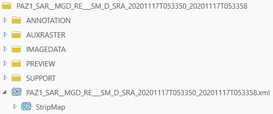
The raster products are in the PAZ dataset directory, where the .xml file represents the raster product container.
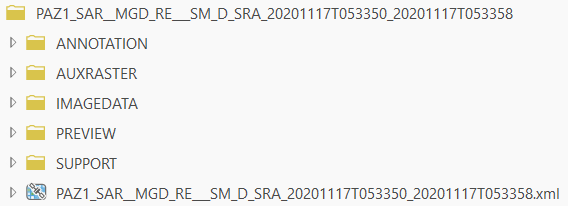
Expanding the .xml file shows you the raster products by the mode. Both the raster container and raster products can be loaded into ArcGIS Pro. The available polarizations are represented as bands in the raster product.
To learn more about PAZ, see the Hisdesat website.
RADARSAT-2
RADARSAT-2 is an MDA and Canadian Space Agency (CSA) joint SAR mission. It is a C-band SAR satellite in a sun-synchronous orbit, operating at a center frequency of 5.404 GHz (wavelength of approximately 5.547 centimeters). The satellite collects data in 20 modes with coverage of up to 530 kilometers and resolutions as fine as 1 meter. Various modes of RADARSAT-2 offer single-polarization (HH or VV), dual-polarization (HH+HV or VV+VH), and quad-polarization (HH+VV+HV+VH) options.
|
Polarization |
Band |
Wavelength (cm) |
|---|---|---|
|
HH |
C |
5.5 |
|
VV |
C |
5.5 |
|
HV |
C |
5.5 |
|
VH |
C |
5.5 |
Product types
The RADARSAT-2 SAR Georeferenced Extra (SGX), SAR Georeferenced Fine (SGF), ScanSAR Narrow Beam (SCN), ScanSAR Wide Beam (SCW), ScanSAR Fine (SCF), ScanSAR Sample (SCS), and Single Look Complex (SLC) products are supported.
SGX, SGF, SCN, SCW, SCF, and SCS—These products are images that have been multilooked and projected to ground range using an Earth ellipsoid model. A ground range image is stored as a real value array. The value in each pixel represents the amplitude of the reflected backscatter signal. Ground range products contain approximately square resolution pixel and square pixel spacing.
SLC - These products are images in the slant range. An SLC image is stored as a complex value array. The single complex value in each pixel represents the amplitude and phase of the reflected backscatter signal.
Processing templates
The following processing templates are available:
Extra Fine—Only Extra Fine mode data will be processed.
Fine—Only Fine mode data will be processed.
Fine Quad Polarization—Only Fine Quad Polarization mode data will be processed.
High Incidence—Only High Incidence mode data will be processed.
Low Incidence—Only Low Incidence mode data will be processed.
Multi-Look Fine—Only Multi-Look Fine mode data will be processed.
ScanSAR Narrow—Only ScanSAR Narrow mode data will be processed.
ScanSAR Wide—Only ScanSAR Wide mode data will be processed.
SpotlightA —Only SpotlightA mode data will be processed.
Standard —Only Standard mode data will be processed.
Standard Quad polarization—Only Standard Quad Polarization mode data will be processed.
Ultrafine —Only Ultrafine mode data will be processed.
Wide —Only Wide mode data will be processed.
The following polarizations are available with RADARSAT-2 products:
HH—The radar signals are transmitted horizontally and received horizontally.
VV—The radar signals are transmitted vertically and received vertically.
HV—The radar signals are transmitted horizontally and received vertically.
VH—The radar signals are transmitted vertically and received horizontally.
HH HV—Dual HH+HV polarization.
VV VH—Dual VV+VH polarization.
HH VV HV VH—Quad-polarization.
Raster product support
The raster product is in the RADARSAT-2 product directory, where the product.xml file represents the raster product container.

Expanding the .xml file shows the raster products by the available mode and type. Both the raster container and raster product can be loaded into ArcGIS Pro. The available polarizations are represented as bands in the raster product.

To learn more about RADARSAT-2, visit the MDA website.
RADARSAT Constellation Mission (RCM)
The RADARSAT Constellation Mission (RCM) is the newest generation CSA C-band SAR satellite constellation. It is composed of three identical satellites equally spaced in a low-Earth orbit and operates at a center frequency of 5.404 GHz (wavelength of approximately 5.547 centimeters). The satellites collect data in 12 modes with coverage of up to 500 kilometers and resolutions as fine as 3 meters. Various modes of RCM offer single-polarization (HH or VV), dual-polarization (HH+HV or VV+VH or HH+VV), quad-polarization (HH+VV+HV+VH), and compact polarization (CH+CV) options.
|
Polarization |
Band |
Wavelength (cm) |
|---|---|---|
|
HH |
C |
5.5 |
|
VV |
C |
5.5 |
|
HV |
C |
5.5 |
|
VH |
C |
5.5 |
|
CH |
C |
5.5 |
|
CV |
C |
5.5 |
Product types
The RCM Ground Range Detected (GRD) product (in GeoTIFF or NITF formats) and Single Look Complex (SLC) product are supported.
Processing templates
The following processing templates are available:
Low Resolution 100m—Only Low Resolution 100m mode data will be processed.
Medium Resolution 50m—Only Medium Resolution 50m (includes High Incidence and High PRF) mode data will be processed.
Medium Resolution 30m—Only Medium Resolution 30m mode data will be processed.
Medium Resolution 16m—Only Medium Resolution 16m mode data will be processed.
High Resolution 5m—Only High Resolution 5m mode data will be processed.
Very High Resolution 3m—Only Very High Resolution 3m mode data will be processed.
Low Noise—Only Low Noise mode data will be processed.
Ship Detection—Only Ship Detection mode data will be processed.
Spotlight—Only Spotlight mode data will be processed.
Quad-polarization—Only Quad-polarization mode data will be processed.
Note that for SLC products, the ScanSAR mode is currently not supported. The following non-ScanSAR modes are supported:
Spotlight
Very High Resolution 3m
High Resolution 5m
Medium Resolution 16m
Quad-polarization
The following polarizations are available with RCM products:
HH—The radar signals are transmitted horizontally and received horizontally.
VV—The radar signals are transmitted vertically and received vertically.
HV—The radar signals are transmitted horizontally and received vertically.
VH—The radar signals are transmitted vertically and received horizontally.
CH—The radar signals are transmitted circularly and received horizontally.
CV—The radar signals are transmitted circularly and received vertically.
HH HV—Dual HH+HV polarization.
VV VH—Dual VV+VH polarization.
HH VV—Dual HH+VV polarization.
CH CV—Dual Compact polarization.
HH VV HV VH—Quad -polarization.
Each mode of RCM acquires the data in multiple beams defined by different incidence angle ranges. Each beam has unique naming known as a beam mnemonic based on the imaging configuration. The beam of interest can be selected using its mnemonic on the RCM raster type property page for a given processing template and polarization type.
Raster product support
The raster product is in the RCM dataset directory, where the manifest.safe file represents the raster product container.

Expanding the manifest.safe file shows the raster products by mode. Both the raster container and raster products can be loaded into ArcGIS Pro. The available polarizations are represented as bands in the raster product.

To learn more about the RCM constellation, visit the Canadian Space Agency website.
Sentinel-1
Sentinel-1 is the European Space Agency's (ESA) C-band SAR satellite constellation comprising four polar-orbiting satellites, Sentinel-1A, Sentinel-1B, Sentinel-1C, and Sentinel-1D. They operate at a center frequency of 5.405 GHz (wavelength of approximately 5.547 centimeters). The satellites collect data in four modes—Stripmap (SM), Interferometric Wide Swath (IW), Extra-Wide Swath (EW), and Wave (WV)—with swath of up to 400 kilometers and resolution as fine as 5 meters. SM, IW, and EW modes offer single (HH or VV) and dual (HH+HV or VV+VH) polarization options; the WV mode only offers a single (HH or VV) polarization option.
|
Polarization |
Band |
Wavelength (cm) |
|---|---|---|
|
HH |
C |
5.5 |
|
VV |
C |
5.5 |
|
HV |
C |
5.5 |
|
VH |
C |
5.5 |
Product types
The Sentinel-1 Ground Range Detected (GRD) and Single Look Complex (SLC) products are supported.
GRD—These products are images that have been multilooked and projected to the ground range using an Earth ellipsoid model. A GRD image is stored as a real value array. The value in each pixel represents the amplitude of the reflected backscatter signal. GRD products contain approximately square resolution cells and square pixel spacing.
SLC—These products are images in the slant range. An SLC image is stored as a complex value array. The single complex value in each pixel represents the amplitude and phase of the reflected backscatter signal.
Processing templates
Currently, the Sentinel-1 raster type only supports the following Level-1 products in IW, SM, and EW modes:
All Swaths—All modes of data will be added. This is the default template and is used for basic visualization.
EW—Only EW data will be processed.
EW1-EW5—Only EW data of subswaths one to five will be processed, respectively.
IW—Only IW data will be processed.
IW1—Only IW subswath 1 data will be processed.
IW2—Only IW subswath 2 data will be processed.
IW3—Only IW subswath 3 data will be processed.
S1-S6—Only SM mode data of swaths one to six will be processed, respectively.
The following polarizations are available with Sentinel-1 products:
HH—The radar signals are transmitted horizontally and received horizontally.
VV—The radar signals are transmitted vertically and received vertically.
HV—The radar signals are transmitted horizontally and received vertically.
VH—The radar signals are transmitted vertically and received horizontally.
HH HV—Dual HH+HV polarization.
VV VH—Dual VV+VH polarization.
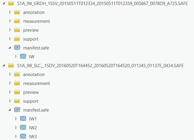
Raster product support
The raster products are in the .SAFE directory, where the manifest.safe file represents the raster product container. Expanding the manifest.safe file shows the raster products by mode. Both the raster container and the raster products can be loaded into ArcGIS Pro. The available polarizations are represented as bands in the raster product.
To learn more about Sentinel-1, visit the European Space Agency website.