
Edit TIN (3D Analyst Tools)

Summary

Loads data from one or more input features to modify the surface of an existing triangulated irregular network (TIN).
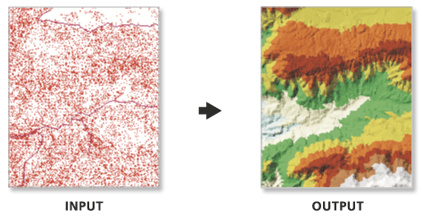
Learn more about how Edit TIN works

Illustration

Edit TIN tool illustration

Breaklines are added to the TIN.

Usage

  • This tool modifies the input TIN. Consider using the Copy TIN tool to maintain a backup if you want to retain an unmodified version of the source TIN.

  • The surface feature type defines how the input features will contribute to the definition of the triangulated surface.

    • Point features can be specified as mass points, which provide data nodes with z-values that are used in the triangulation of the surface.

    • Line features can be specified as mass points and breaklines, which represent locations along a surface with linear discontinuities in slope, such as ridge lines, shore lines, pavement edges, building footprints, and so on.

    • Polygon features can also be specified as mass points and breaklines, along with clip features that define the data area, replace features that define regions with constant z-values (for example, water bodies), and erase features that indicate interior areas where data does not exist.

  • The tool can create a TIN composed of many millions of points given enough memory. However, limiting the number of TIN nodes to less than 6 million will ensure a responsive display performance and overall usability. If a larger TIN surface is needed, consider using a terrain dataset. The terrain dataset offers a multiresolution TIN surface that can support much larger collections of source measurements.

Parameters

Label Explanation Data type

Input TIN

The TIN dataset that will be processed.

TIN Layer

Surface Feature Definition

The input features and their related properties that define how they will be added to the TIN.

Value table columns:

  • Input FeaturesThe features that will be added to the TIN.

  • Height FieldThe field from the input's attribute table that will provide the elevation for its features. The z- or m-values in the Shape field can be used along with any numeric field. Choosing the <None> option will result in the feature's elevation being interpolated from its surrounding 3D measurements.

  • Tag FieldA numeric attribute will be assigned to the TIN's data elements using values obtained from an integer field in the input feature's attribute table.

  • TypeThe input feature's role in defining the TIN surface. The available options depend on the geometry of the input features. For line- and polygon-based surface feature types, the hard and soft designations for the surface feature type impact the way the line or polygon boundary is handled when interpolating a raster surface from the TIN dataset when using natural neighbor interpolation. A hard surface feature type represents a border with a sharp discontinuity in elevation, such as the edge of a cliff, a wall, or a curb on the side of the road. A soft surface feature type represents a border where the elevation is more smoothly defined.

    • Mass PointsElevation measurements will be incorporated as TIN nodes.

    • Hard LineBreakline features will define linear discontinuities in the TIN.

    • Soft LineBreakline features will define linear discontinuities in the TIN.

    • Hard ClipPolygon features will define the data area of the TIN surface.

    • Soft ClipPolygon features will define the data area of the TIN surface.

    • Hard ErasePolygon features will define interior voids in the data.

    • Soft ErasePolygon features will define interior voids in the data.

    • Hard ReplacePolygon features will define areas of constant height.

    • Soft ReplacePolygon features will define areas of constant height.

    • Hard Value FillInteger attributes will be assigned to nodes and triangle faces.

    • Soft Value FillInteger attributes will be assigned to nodes and triangle faces.

  • Use ZSpecifies whether z- or m-values will be used when the SHAPE field is specified as the height source. Specifying True indicates that z-values will be used; specifying False indicates that m-values will be used.

Value Table

Constrained Delaunay

(Optional)

Specifies the triangulation technique that will be used along the breaklines of the TIN.

  • CheckedThe TIN will use constrained Delaunay triangulation, which will add each segment as a single edge. Delaunay triangulation rules are honored everywhere except along breaklines, which will not be densified.

  • UncheckedThe TIN will use Delaunay conforming triangulation, which may densify each segment of the breaklines to produce multiple triangle edges. This is the default.

Boolean

Derived output

Label Explanation Data type

Updated TIN

The updated TIN.

TIN Layer

Environments

Current Workspace, Extent

Licensing information

  • Basic: Requires 3D Analyst
  • Standard: Requires 3D Analyst
  • Advanced: Requires 3D Analyst