Float (3D Analyst Tools)
Summary
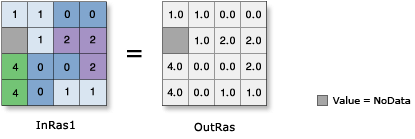
Converts each cell value of a raster into a floating-point representation.
Illustration
Usage
The input values can be positive or negative.
If you execute Float on an input that is already floating point, the output values will remain the same as the input values.
If the input is a multiband raster, the output will be a multiband raster. The tool will perform the operation on each band in the input.
If the input is multidimensional raster data, all slices from all variables will be processed. The output will be a multidimensional raster in CRF format.
Parameters
| Label | Explanation | Data type |
|---|---|---|
|
Input raster or constant value |
The input raster to be converted to floating point. To use a number as an input for this parameter, the cell size and extent must first be set in the environment. |
Raster Layer; Constant |
|
Output raster |
The output raster. The cell values are the floating-point representation of the input values. |
Raster Dataset |
Environments
Auto Commit, Cell Size, Cell Size Projection Method, Current Workspace, Extent, Geographic Transformations, Mask, Output CONFIG Keyword, Output Coordinate System, Scratch Workspace, Snap Raster, Tile Size
Licensing information
- Basic: Requires 3D Analyst or Spatial Analyst or Image Analyst
- Standard: Requires 3D Analyst or Spatial Analyst or Image Analyst
- Advanced: Requires 3D Analyst or Spatial Analyst or Image Analyst