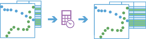
Calculate Motion Statistics (GeoAnalytics Server Tools)
Summary
Calculates motion statistics for points in a time-enabled feature class.
Legacy:
The ArcGIS GeoAnalytics Server extension is being deprecated in ArcGIS Enterprise. The final release of GeoAnalytics Server was included with ArcGIS Enterprise 11.3. This geoprocessing tool is available through ArcGIS Enterprise 11.3 and earlier versions.
Illustration
Usage
This geoprocessing tool is available with ArcGIS Enterprise 10.9 or later.
The result of Calculate Motion Statistics is a copy of the input points with a new field for each calculated statistic.
You can specify one or more fields to identify unique entities, also known as tracks. Tracks are represented by the unique combination of one or more track fields. For example, if the
flightIDandDestinationfields are used as track identifiers, theID007,Solden,ID007, andTokoyofeatures would be in two separate tracks, since they have differentDestinationfield values.By default, all supported statistics will be calculated for each input point if possible. Alternatively, you can choose one or more groups of statistics to calculate using the Motion Statistics parameter.
The following statistics fields will be calculated for the Distance group:
Distance—Distance traveled from the previous observation to the current.TotDistance—Sum of distances traveled between observations in the track history window.MinDistance—Minimum of distances traveled between observations in the track history window.MaxDistance—Maximum of distances traveled between observations in the track history window.AvgDistance—Average of distances traveled between observations in the track history window.
The following statistics fields will be calculated for the Speed group:
Speed—Speed of travel from the previous observation to the current.MinSpeed—Minimum speed between observations in the track history window.MaxSpeed—Maximum speed between observations in the track history window.AvgSpeed—Sum of distances between observations in the track history window divided by the sum of durations between observations in the track history window.
The following statistics fields will be calculated for the Acceleration group:
Acceleration—Difference between the current speed and previous speed divided by the current duration.MinAcceleration—Minimum acceleration calculated in the track history window.MaxAcceleration—Maximum acceleration calculated in the track history window.AvgAcceleration—Difference between the current and first speeds in the track history window divided by the sum of durations between observations in the track history window.
The following statistics fields will be calculated for the Duration group:
Duration—Elapsed time since the previous observation.TotDuration—Sum of durations in the track history window.MinDuration—Minimum duration in the track history window.MaxDuration—Maximum duration in the track history window.AvgDuration—Sum of durations in the track history window divided by the number of durations calculated in the track history window.
The following statistics fields will be calculated for the Elevation group:
Elevation—Current elevation of the observation.ElevChange—Difference between the current elevation and the previous elevation.TotElevChange—Sum of elevation changes between points in the track history window. This can be a negative value.MinElevation—Minimum elevation in the track history window.MaxElevation—Maximum elevation in the track history window.AvgElevation—Sum of elevations in the track history window divided by the number of observations in the track history window.
The following statistics fields will be calculated for the Slope group:
Slope—Ratio of elevation change to distance between the current and previous observations.MinSlope—Minimum slope in the track history window.MaxSlope—Maximum slope in the track history window.AvgSlope—Sum of slopes in the track history window divided by the number of slopes calculated in the track history window.
The following statistics fields will be calculated for the Idle group:
Idling—Trueif the distance between the current observation and the previous is less than the Idle Distance Tolerance parameter value, and the duration between the current observation and the previous is greater than the Idle Time Tolerance parameter value.Falseif one or both of these conditions are not met.TotIdleTime—Sum of durations in the track history window that meet idling criteria.PctIdleTime—Percentage of time for which idling was detected.
The following statistics field will be calculated for the Bearing group:
Bearing—Angle of travel from the previous observation to the current observation.
Statistics starting with Min, Max, Avg, or Tot will be calculated using the current observation and a number of previous observations defined by the Track History Window parameter. Other statistics are always calculated using only the current and previous observation and do not consider the Track History Window values. For example, if you set a Track History Window value of 5 and request the Speed statistic group, the current observation and the previous 4 observations will be used to calculate the
MinSpeed,MaxSpeed, andAvgSpeedfields at each observation, while theSpeedfield will be calculated using only the current and previous observations at each point. The Track History Window parameter value must be greater than 1. The default is 3.The diagram below shows a track with six point features. The statistics are calculated based on each feature's elevation, distance, and time.
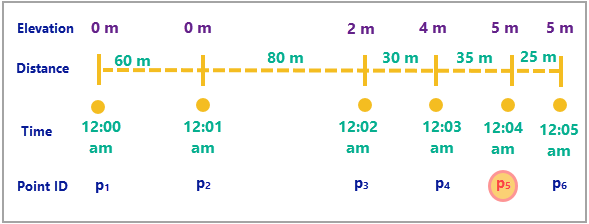
The following table summarizes the statistics calculations for the diagram above. All calculations are evaluated at point 5 and the track history window is 3. An observation is considered idling if it has moved less than 32 meters in 1 minute.
Statistic
Formula
Example
Distance
35 m
Total Distance
80 + 30 + 35 = 145 m
Speed
Distance / Duration
35 / 60 = 0.58 m/s
Average Speed
Total Distance / Total Duration
145 / 180 m/s
Acceleration
(0.58 – 0.5) / 60 = 0.001 m/s2
Average Acceleration
(Speed (last) – Speed (first)) / (Total Duration)
(0.58 – 1.33) / 60 = -0.01 m/s2
Duration
60 s
Total Duration
60 + 60 + 60 = 180 s
Elevation
5 m
Elevation Change
5 – 4 = 1 m
Total Elevation Change
5 – 0 = 5 m
Slope
Elevation Change / Distance
1 / 35
Average Slope
Total Elevation Change / Total Distance
5 / 145
Idling
False
Total Idle Time
60 s
Percentage Idle Time
1 / 3
Bearing
0
If there are fewer observations in a track's history than the Track History Window parameter value, statistics starting with Min, Max, Avg, or Tot will be calculated using all observations in the track history.
Statistics will not be calculated for the first feature in each track. Statistics in the Acceleration group will not be calculated for the first two features in each track.
The result values will be in the units specified by the Distance Unit, Duration Unit, Speed Unit, Acceleration Unit, and Elevation Unit parameters.
When calculating statistics on large tracks, you can use the Time Boundary Split parameter to split the large tracks into smaller tracks to improve performance.
This geoprocessing tool is powered by ArcGIS GeoAnalytics Server. Analysis is completed on GeoAnalytics Server, and results are stored in your content in ArcGIS Enterprise.
When running GeoAnalytics Server tools, the analysis is completed on GeoAnalytics Server. For optimal performance, make data available to GeoAnalytics Server through feature layers hosted on your ArcGIS Enterprise portal or through big data file shares. Data that is not local to GeoAnalytics Server will be moved to GeoAnalytics Server before analysis begins. This means that it will take longer to run a tool and, in some cases, moving the data from ArcGIS Pro to GeoAnalytics Server may fail. The threshold for failure depends on your network speeds, as well as the size and complexity of the data. It is recommended that you always share your data or create a big data file share.
Learn more about sharing data to your portal
Learn more about creating a big data file share through Server Manager
You can improve the performance of the Calculate Motion Statistics tool by doing any or all of the following:
Set the extent environment so you only analyze data of interest.
Decrease the Track History Window parameter value.
Use the Time Boundary Split parameter to break up large tracks at a defined time interval.
Use data that is local to where the analysis is being run.
Parameters
| Label | Explanation | Data type |
|---|---|---|
|
Input Layer |
The time-enabled point features on which motion statistics will be calculated. |
Feature Set |
|
Output Name |
The name of the result layer. |
String |
|
Track Fields |
One or more fields that will be used to identify distinct entities. |
Field |
|
Track History Window (Optional) |
The number of observations (including the current observation) that will be used for summary statistics. The default value is 3, which means that the summary statistics will be calculated at each point in a track using the current observation and the previous two observations. This parameter does not affect instantaneous statistics or idle classification. |
Long |
|
Motion Statistics (Optional) |
Specifies the group containing the statistics that will be calculated and written to the result. If no value is specified, all statistics from all groups will be calculated.
|
String |
|
Distance Method (Optional) |
Specifies the distance measurement method that will be used when calculating motion statistics.
|
String |
|
Idle Distance Tolerance (Optional) |
The maximum distance that two sequential points in a track can be apart and still be considered idle. This parameter is used with the Idle Time Tolerance parameter to determine whether an entity is idling. The Idle Distance Tolerance parameter is required if the Idle statistic group is specified for the Motion Statistics parameter or if statistics in all the groups will be calculated. |
Linear Unit |
|
Idle Time Tolerance (Optional) |
The minimum duration that two sequential points in a track must be near each other to be considered idle. This parameter is used with the Idle Distance Tolerance parameter to determine whether an entity is idling. The Idle Time Tolerance parameter is required if the Idle statistic group is specified for the Motion Statistics parameter or if statistics in all the groups will be calculated. |
Time Unit |
|
Time Boundary Split (Optional) |
A time span to split the input data into for analysis. A time boundary allows you to analyze values within a defined time span. For example, if you use a time boundary of 1 day, starting on January 1, 1980, tracks will be split at the beginning of every day. This parameter is only available with ArcGIS Enterprise 10.7 and later. |
Time Unit |
|
Time Boundary Reference (Optional) |
The reference time used to split the input data into for analysis. Time boundaries will be created for the entire span of the data, and the reference time does not need to occur at the start. If no reference time is specified, January 1, 1970, is used. This parameter is only available with ArcGIS Enterprise 10.7 and later. |
Date |
|
Distance Unit (Optional) |
Specifies the unit of measure that will be used for distance values in the output feature class.
|
String |
|
Duration Unit (Optional) |
Specifies the unit of measure that will be used for duration values in the output feature class.
|
String |
|
Speed Unit |
Specifies the unit of measure that will be used for speed values in the output feature class.
|
String |
|
Acceleration Unit (Optional) |
Specifies the unit of measure that will be used for acceleration values in the output feature class.
|
String |
|
Elevation Unit (Optional) |
Specifies the unit of measure that will be used for elevation values in the output feature class.
|
String |
|
Data Store (Optional) |
Specifies the ArcGIS Data Store where the output will be stored. All results stored in a spatiotemporal big data store will be stored in WGS84. Results stored in a relational data store will maintain their coordinate system.
|
String |
Derived output
| Label | Explanation | Data type |
|---|---|---|
|
Output Feature Layer |
The output point features with motion statistics. |
Feature Set |
Environments
Output Coordinate System, Extent, Current Workspace
Special cases
- Output Coordinate System
-
The coordinate system that will be used for analysis. Analysis will be completed in the input coordinate system unless specified by this parameter. For GeoAnalytics Tools, final results will be stored in the spatiotemporal data store in WGS84.
Licensing information
- Basic: Requires ArcGIS GeoAnalytics Server
Available with ArcGIS Enterprise 10.9 - Standard: Requires ArcGIS GeoAnalytics Server
Available with ArcGIS Enterprise 10.9 - Advanced: Requires ArcGIS GeoAnalytics Server
Available with ArcGIS Enterprise 10.9