Dissolve Boundaries (GeoAnalytics Server Tools)
Summary
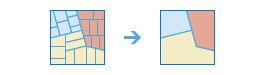
Finds polygons that intersect or have the same field values and merges them to form a single polygon.
Legacy:
The ArcGIS GeoAnalytics Server extension is being deprecated in ArcGIS Enterprise. The final release of GeoAnalytics Server was included with ArcGIS Enterprise 11.3. This geoprocessing tool is available through ArcGIS Enterprise 11.3 and earlier versions.
Which boundaries are merged can be controlled by specifying one or more fields. For example, if you have a layer of counties and each county has a State_Name field, you can dissolve boundaries using the State_Name field. Adjacent counties will be merged if they have the same value for State_Name. The result is a layer of state boundaries.
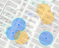
Illustration
Usage
The Input Layer features must have polygon geometry. The dissolved output features will always be polygons.
There are two types of polygons that can have their boundaries dissolved: polygons that intersect and polygons that have the same field value.
Polygon features that have intersecting boundaries will be dissolved by default. Optionally, you can use the Dissolve Field(s) parameter to dissolve intersecting polygons that have one or more of the same field values.
For example, if you have a layer of study areas with a
Soil_Typefield, you can dissolve boundaries based on the attributes of theSoil_Typefield. Study areas will be merged if they have the same value forSoil_Type. The result is a layer of study areas by soil type. If two or more fields are specified, the input features must have the same value for each for the boundary to be dissolved.The attributes of the features that become aggregated by dissolve can be summarized or described using a variety of statistics in the Summary Fields parameter. The statistic used to summarize attributes is added to the output feature class as a single field with the naming standard of statistic type + underscore + input field name. For example, if the SUM statistic is used on a field named
POP, the output will have a field namedSUM_POP.Output from the Dissolve Boundaries tool can include multipart or single part features. A multipart feature is defined as one feature that is broken up into noncontiguous parts. For example, the state of Hawaii can be considered a multipart feature because its separate geometric parts are classified as a single state. The Create multipart features parameter offers two options for creating multipart or single part output:
True (checked)—Multipart features will be created in the output if applicable.
False (unchecked)—Only single part features will be created in the output. This is the default.
The following table outlines how the Create multipart features parameter operates with the dissolve options:
Dissolve method
Multipart is false (default)
Multipart is true
Dissolve Field(s) is not specified (default).
Three features are created when all values are dissolved and multipart is false. Only overlapping features are dissolved.
One feature is created when all values are dissolved and multipart is true. When you select this option, the result will always be one feature.
Dissolve Field(s) is specified.
Four features are created when the dissolve is applied based on the field (here, the field is the color of input points). Only overlapping features with the same value of the specified fields are dissolved.
Two features are created when the dissolve is applied based on the field (here, the field is the color of input points) and multiparts are allowed. Values with the same field value will always be a single feature.
This geoprocessing tool is powered by ArcGIS GeoAnalytics Server. Analysis is completed on GeoAnalytics Server, and results are stored in your content in ArcGIS Enterprise.
When running GeoAnalytics Server tools, the analysis is completed on GeoAnalytics Server. For optimal performance, make data available to GeoAnalytics Server through feature layers hosted on your ArcGIS Enterprise portal or through big data file shares. Data that is not local to GeoAnalytics Server will be moved to GeoAnalytics Server before analysis begins. This means that it will take longer to run a tool and, in some cases, moving the data from ArcGIS Pro to GeoAnalytics Server may fail. The threshold for failure depends on your network speeds, as well as the size and complexity of the data. It is recommended that you always share your data or create a big data file share.
Parameters
| Label | Explanation | Data type |
|---|---|---|
|
Input Features |
The layer containing the polygon features that will be dissolved. |
Feature Set |
|
Output Name |
The name of the output feature service. |
String |
|
Create Multipart Features (Optional) |
Specifies whether multipart features will be created in the output feature class.
|
Boolean |
|
Dissolve by Field Value(s) (Optional) |
Specifies whether features with the same field values will be dissolved.
|
Boolean |
|
Dissolve Field(s) |
The field or fields that will be used to dissolve like features. Features with the same value for each field will be dissolved. |
Field |
|
Summary Fields |
The statistics that will be calculated on specified fields. Value table columns:
|
Value Table |
|
Data Store (Optional) |
Specifies the ArcGIS Data Store where the output will be stored. All results stored in a spatiotemporal big data store will be stored in WGS84. Results stored in a relational data store will maintain their coordinate system.
|
String |
Derived output
| Label | Explanation | Data type |
|---|---|---|
|
Output |
The dissolved output. |
Record Set |
Environments
Output Coordinate System, Extent, Current Workspace
Special cases
- Output Coordinate System
-
The coordinate system that will be used for analysis. Analysis will be completed in the input coordinate system unless specified by this parameter. For GeoAnalytics Tools, final results will be stored in the spatiotemporal data store in WGS84.
Licensing information
- Basic: Requires ArcGIS GeoAnalytics Server
Available with ArcGIS Enterprise 10.7 - Standard: Requires ArcGIS GeoAnalytics Server
Available with ArcGIS Enterprise 10.7 - Advanced: Requires ArcGIS GeoAnalytics Server
Available with ArcGIS Enterprise 10.7