Summarize Within (Standard Feature Analysis Tools)
Summary
Finds the point, line, or polygon features (or portions of features) that are within the boundaries of polygons in another layer.
The following are example scenarios for the use of this tool:
For a layer of watershed boundaries and a layer of land-use boundaries by land-use type, calculate total acreage of land-use type for each watershed.
For a layer of parcels in a county and a layer of city boundaries, summarize the average value of vacant parcels within each city boundary.
For a layer of counties and a layer of roads, summarize the total mileage of roads by road type within each county.
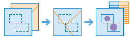
Illustration
Usage
- You can think of this tool as taking two layers and stacking them on top of each other. For example, the features in one of the layers, the input polygons layer, are all colored red. The other layer, the input summary features, can be any feature type—point, line, or polygon. After stacking these layers on top of each other, you look down through the stack and count the number of features in the input summary features layer that are within the polygons with the red boundaries (the input polygons). Not only can you count the number of features, you can calculate simple statistics about the attributes of the features in the input summary features layer, such as sum, mean, minimum, maximum, and so on.
Parameters
| Label | Explanation | Data type |
|---|---|---|
|
Input Polygons |
The features, or portions of features, from the Input Summary Features parameter value that are within the boundaries of these polygons will be summarized. |
Feature Set |
|
Input Summary Features |
The point, line, or polygon features that will be summarized for each input polygon. |
Feature Set |
|
Output Name |
The name of the output layer that will be created on your portal. |
String |
|
Add shape summary attributes (Optional) |
Specifies whether statistics will be calculated based on the shape of the Input Summary Features parameter value, such as the length of lines or areas of polygons of the input summary features within each input polygon.
|
Boolean |
|
Shape Unit (Optional) |
Specifies the units that will be used for the shape summary. When the input summary features are polygons, the valid options are acres, hectares, square meters, square kilometers, square feet, square yards, and square miles. When the input summary features are lines, the valid options are miles, feet, kilometers, meters, and yards.
|
String |
|
Summary Fields (Optional) |
A list of field names and statistical summary type that will be calculated for all points within each polygon. The count of points within each polygon is always returned. Value table columns:
|
Value Table |
|
Group By Field (Optional) |
A field from the input summary features that will be used to calculate statistics separately for each unique attribute value. For example, the Input Summary Features parameter value contain point locations of businesses that store hazardous materials, and the |
Field |
|
Add minority and majority attributes (Optional) |
Specifies whether minority and majority fields will be added to the output. This parameter only applies when using the Group By Field parameter.
|
Boolean |
|
Add group percentages (Optional) |
Specifies whether group percentage fields will be added to the output. This parameter only applies when using the Group By Field parameter.
|
Boolean |
Derived output
| Label | Explanation | Data type |
|---|---|---|
|
Output Feature Service |
The output summarized layer. |
Feature Set |
|
Output Group Table |
If a group by field was provided, the tool will output a table that contains the calculated statistics for each unique group. |
Record Set |
Environments
Licensing information
- Basic: Requires your account in ArcGIS Enterprise to have the Perform Analysis privilege
- Standard: Requires your account in ArcGIS Enterprise to have the Perform Analysis privilege
- Advanced: Requires your account in ArcGIS Enterprise to have the Perform Analysis privilege