Diff (Image Analyst Tools)
Summary
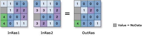
Determines which values from the first input are logically different from the values of the second input on a cell-by-cell basis.
If the values on the two inputs are different, the value on the first input is output. If the values on the two inputs are the same, the output is 0.
Illustration
Usage
Two inputs are necessary for this logical evaluation to take place.
The order of inputs is relevant for this tool.
If both inputs are integer, the output will be an integer raster; otherwise, it will be a floating-point raster.
If both inputs are single-band rasters or one of the inputs is a constant, the output will be a single-band raster.
If both inputs are multiband rasters, the tool will perform the operation on each band from one input, and the output will be a multiband raster. The number of bands in each multiband input must be the same.
If one of the inputs is a multiband raster and the other input is a constant, the tool will perform the operation using the constant value for each band in the multiband input, and the output will be a multiband raster.
If both inputs are multidimensional raster data with the same number of variables, the tool will perform the operation for all slices with the same dimension value. The output will be a multidimensional raster in CRF format. The variables in the inputs must have at least one common dimension and one common dimensional value for this tool to process; otherwise, an error will occur.
If both inputs have one variable but different names, uncheck the Match Multidimensional Variable geoprocessing environment (set
arcpy.env.matchMultidimensionalVariable = Falsein Python) before running the tool.If one of the inputs is a multidimensional raster and the other input is a constant, the tool will perform the operation for all slices for all variables using the constant value, and the output will be a multidimensional raster.
Parameters
| Label | Explanation | Data type |
|---|---|---|
|
Input raster or constant value 1 |
The input to which the second input will be compared. A number can be used as an input for this parameter, provided a raster is specified for the other parameter. To specify a number for both inputs, the cell size and extent must first be set in the environment. |
Raster Layer; Constant |
|
Input raster or constant value 2 |
The input to which the first input will be compared. A number can be used as an input for this parameter, provided a raster is specified for the other parameter. To specify a number for both inputs, the cell size and extent must first be set in the environment. |
Raster Layer; Constant |
Return value
| Label | Explanation | Data type |
|---|---|---|
|
Output raster |
The output raster. The values in the output will be either 0 if the two input values are the same, or the first input value if they are not. |
Raster |
Environments
Auto Commit, Cell Size, Cell Size Projection Method, Compression, Current Workspace, Extent, Geographic Transformations, Mask, Output CONFIG Keyword, Output Coordinate System, Scratch Workspace, Snap Raster, Tile Size
Licensing information
- Basic: Requires Image Analyst or Spatial Analyst
- Standard: Requires Image Analyst or Spatial Analyst
- Advanced: Requires Image Analyst or Spatial Analyst