InList (Image Analyst Tools)
Summary
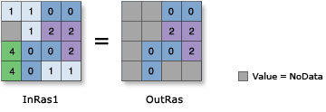
Determines which values from the first input are contained in a set of other inputs, on a cell-by-cell basis.
For each cell, if the value of the first input raster is found in any of the list of other inputs, that value will be assigned to the output raster. If it is not found, the output cell will be NoData.
Illustration
Usage
If all of the inputs are integer, the output raster will be integer. If any of the inputs are floating point, the output will be floating point.
In the list of input rasters, the order is not relevant to the outcome of this tool.
If the Process as multiband parameter is unchecked (
process_as_multibandis set toSINGLE_BANDin Python), only the first band of a multiband Input raster or constant value (input_raster_or_constantin Python) will be used. Each band from a multiband Input rasters or constant values (in_rasters_or_constantsin Python) will be processed separately as a single band raster.If the Process as multiband parameter is checked (
process_as_multibandis set toMULTI_BANDin Python), each multiband raster input will be processed as a multiband raster.The number of bands in the output depends on the Input raster or constant value parameter. If the input raster is a single band or a constant, the number of bands in the output raster will be the same as the maximum number of bands of all multiband rasters from the Input rasters or constant values. If the input raster is a multiband, the output raster will have the same number of bands as the input raster.
If any of the Input rasters or constant values is a raster with a smaller number of bands than the output raster, the missing bands will be interpreted as a band filled with NoData. If any of the entries in the input list is a constant, it will be interpreted as a multiband raster in which the cell values of all bands are the same as the constant and have the same number of bands as the output raster.
Parameters
| Label | Explanation | Data type |
|---|---|---|
|
Input raster or constant value |
The input that defines the value that will be looked for in a list of rasters on a cell-by-cell basis. A number can be used as an input for this parameter, provided a raster is specified for the other parameter. To specify a number for both inputs, the cell size and extent must first be set in the environment. |
Raster Layer; Constant |
|
Input raster or constant values |
A list of input rasters that the first input will be evaluated against. For each location, if the cell value from the first input exists in any of the other rasters, that value will be assigned to the output raster. If the value does not exist in any of the other rasters, the output value at that location will be NoData. A number can be used as an input for this parameter, provided a raster is specified for the other parameter. To specify a number for both inputs, the cell size and extent must first be set in the environment. |
Raster Layer; Constant |
|
Process as multiband (Optional) |
Specifies how the input multiband raster bands will be processed.
|
Boolean |
Return value
| Label | Explanation | Data type |
|---|---|---|
|
Output raster |
The output raster. |
Raster |
Environments
Auto Commit, Cell Size, Cell Size Projection Method, Compression, Current Workspace, Extent, Geographic Transformations, Mask, Output CONFIG Keyword, Output Coordinate System, Scratch Workspace, Snap Raster, Tile Size
Licensing information
- Basic: Requires Image Analyst or Spatial Analyst
- Standard: Requires Image Analyst or Spatial Analyst
- Advanced: Requires Image Analyst or Spatial Analyst