Round Up (Image Analyst Tools)
Summary
Returns the next higher integer value, just represented as a floating point, for each cell in a raster.
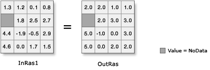
Illustration
Usage
Input values can be positive or negative.
The output raster from this tool is always floating-point type, regardless of the input value type.
If the input number has any values to the right of the decimal point, the output will be assigned the next higher integer value, but will be represented as a floating point number with no decimal portion. For example:
Input   Output
 5.3     6.0
 4.9     5.0
 3.0     3.0
 6.5     7.0
-0.2     0.0
-2.8    -2.0
If the input is a multiband raster, the output will be a multiband raster. The tool will perform the operation on each band in the input.
If the input is multidimensional raster data, all slices from all variables will be processed. The output will be a multidimensional raster in CRF format.
Parameters
| Label | Explanation | Data type |
|---|---|---|
|
Input raster or constant value |
The input values to be rounded up. To use a number as an input for this parameter, the cell size and extent must first be set in the environment. |
Raster Layer; Constant |
Return value
| Label | Explanation | Data type |
|---|---|---|
|
Output raster |
The output raster. The cell values are the result of rounding up the input values. |
Raster |
Environments
Auto Commit, Cell Size, Cell Size Projection Method, Current Workspace, Extent, Geographic Transformations, Mask, Output CONFIG Keyword, Output Coordinate System, Scratch Workspace, Snap Raster, Tile Size
Licensing information
- Basic: Requires Image Analyst or Spatial Analyst
- Standard: Requires Image Analyst or Spatial Analyst
- Advanced: Requires Image Analyst or Spatial Analyst