How Surface Area Ratio works
![]() Available with Spatial Analyst license.
Available with Spatial Analyst license.
The Surface Area Ratio tool calculates the surface area to planar area ratio for each cell on the input surface raster. As a measure of surface rugosity, the output raster of this tool is typically used in modeling surface structural complexity and wildlife habitats in the seafloor or land ecosystems.
An important parameter in the Surface Area Ratio tool is the Planar Area Type. It defines how the surface area of each cell is projected on a plane when calculating the planar area. The parameter has two available options: Horizontal and Arc-Chord.
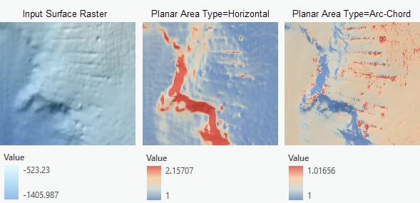
How the planar area for each cell is calculated
With the Horizontal planar area type, the planar area is the cell’s surface area projected on the horizontal plane, which equals the cell area of the input raster. The tool will output a surface area ratio raster that is dependent on local slopes. It means that, in addition to the roughness of the terrain, the local slope also contributes to the output values. An output value near 1 represents a flat area. Higher values point to areas with higher terrain roughness or steep slopes.
With the Arc-Chord planar area type, the planar area is the cell’s surface area projected on a plane of best fit in a local 3 by 3 neighborhood (Du Preez, 2015). It is calculated by dividing the cell area by the cosine of the local slope. This decouples the effect of the local slope from the output. The output in this case helps understand whether the terrain is flat, or if it has a smooth slope (with values near 1), along with its roughness (with values greater than 1).
How the 3D surface area for each cell is calculated
For each cell, the 3D surface area is determined by performing the following steps:
A TIN is created in the 3 by 3 cell neighborhood, by connecting the current cell center to the 8 neighboring cells.
The TIN is then clipped to the cell boundary. Each cell consists of 8 triangles.
For each triangle, the area is calculated using the three sides of the triangle (Jenness, 2004).
The 3D area is calculated by summing up the areas of the 8 triangles.
The result surface area ratio is calculated by dividing the 3D surface area by the planar area at each cell location.
References
Jenness, J.S. Calculating landscape surface area from digital elevation models. Wildlife Society Bulletin, 2004, 32, 829-839.
Du Preez, C. A new arc–chord ratio (ACR) rugosity index for quantifying three-dimensional landscape structural complexity. Landscape Ecology, 2015, 30, 181–192.