What is ArcGIS Reality Server
Note:
ArcGIS Reality Server is a beta feature at ArcGIS Enterprise 12.1. While in beta, this capability may not be feature complete and, as such, may have known performance or quality issues and will not be supported by Esri Technical Support.
Feedback on this feature can be provided in the ArcGIS Enterprise 12.1 Beta Features Early Adopter Community.
ArcGIS Reality Server provides distributed computing and storage systems that powers reality mapping capabilities for large collections of drones, digital aerial, and satellite images. It allows you to manage and process a large collection of overlapping images from different platforms and sensors and generate high-fidelity 2D and 3D products in a scalable and self-hosted environment. This capability can be further expanded by using cloud computing capabilities and resources. As a result, reality mapping tasks that used to take days or weeks can now be done in hours, and jobs that were too large or extensive can now be handled.
Key capabilities
ArcGIS Reality Server provides a comprehensive toolset for reality mapping workflows, including image management, adjustment, and generation of 2D and 3D products. These tools are based on the same technology in ArcGIS Pro but are optimized for enterprise scalability through distributed processing and project-based workflows.
Reality mapping workflow management
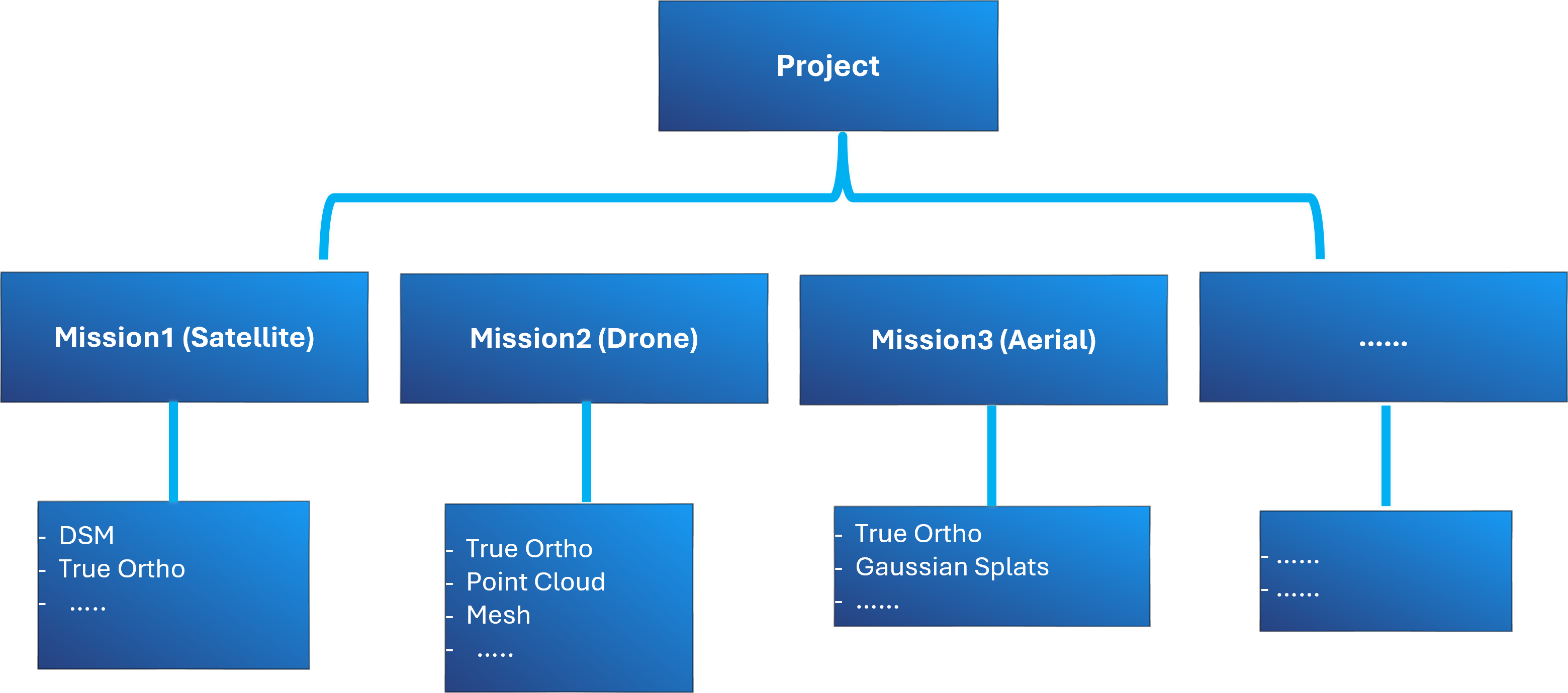
ArcGIS Reality Server uses projects and missions to manage reality mapping across one or more data capture sessions.
A project is a top-level workspace for managing reality mapping activities. It organizes all imagery acquisition, processing, and outputs associated with a specific geographic location or mapping effort across one or more missions.
A mission is a container for a single data capture session, holding all related imagery and the resulting processed data products. A project can include multiple missions from different capture sources, such as satellite, drone, or aerial. Each mission independently stores its own data products, which can include outputs such as DSM, true ortho, point cloud, mesh, and Gaussian splats, depending on the capture type and processing performed.
Block Adjustment
ArcGIS Reality Server includes the following advanced tools for image adjustment, which is essential for accurate geospatial products:
Tie Point Computation—Detect and match common points across overlapping images.
Triangulation—Calculate precise camera positions and orientations.
Orthorectification—Correct distortions caused by terrain and sensor geometry.
These tools use sensor-specific algorithms to ensure accuracy for different platforms, from UAVs to high-resolution satellites.
Generating products
ArcGIS Reality Server supports the creation of various 2D and 3D products from drone, digital aerial, and satellite images. The possible products are described below:
DSM—A digital surface model (DSM) of the earth and features above the surface. This is generated from a collection of overlapping images.
DTM—A digital terrain model (DTM) of the earth with above-ground objects such as trees, buildings, vehicles, and so on removed. A DTM is also referred to as bare earth elevation.
Orthomosaic—A composite image in which distortions caused by camera tilt, terrain, and lens distortion have been removed. This correction ensures that the scale is uniform across the image. It provides accurate locations for features on the ground, while above-ground features such as buildings and trees will appear to lean away from the camera and may not be in their correct horizontal location.
True Ortho—An orthorectified image without perspective distortion so that above-ground features do not lean and obscure other features.
DSM Mesh—A 2.5D textured model in which the adjusted images are draped on a triangulated irregular network (TIN) version of the DSM extracted from overlapping images.
Point Cloud—3D points representing the ground surface and features above the ground derived from overlapping imagery.
Mesh—A 3D textured model in which the ground and above-ground feature facades are densely and accurately reconstructed.
Distributed processing
ArcGIS Reality Server uses parallel processing across multiple machines and distributed storage to handle many large-scale reality mapping tasks. This architecture reduces processing time, allowing organizations to complete projects in hours instead of days. Check this page to learn how to manage reality server project distribution for optimal performance.
Collaboration and sharing
ArcGIS Reality Server is designed for enterprise collaboration, as follows:
Users across your organization can contribute data, share expertise, and publish results securely.
All source data and generated products are stored and shared through your ArcGIS Enterprise portal, ensuring controlled access and governance.
Deployment
ArcGIS Reality Server can be deployed as follows:
On-premises, for organizations with strict data governance requirements.
In the cloud, using Amazon Web Services or Microsoft Azure. Deployment is streamlined with ArcGIS Enterprise Cloud Builder tools, which simplify site creation and configuration.
Use the standard ArcGIS Enterprise pattern to install the following:
The Enterprise portal, hosting ArcGIS Server site, and relational ArcGIS Data Store
ArcGIS Server on additional machines and assign the Reality Server role to the site
Learn more about deployment details and system requirements
Summary
ArcGIS Reality Server transforms imagery collections into high-fidelity 2D and 3D products quickly and securely by combining the following:
Distributed processing for speed
Enterprise collaboration for efficiency
This allows organizations to scale reality mapping workflows and deliver accurate, actionable geospatial intelligence for decision-making, planning, and digital twin initiatives.