Rotate Aviation Features (Aviation Tools)
Résumé
Aligns features to a grid or to the page.
Using this tool, you can automate the rotation of point and annotation features on a chart to make them easier to read.
Utilisation
Target point layers must have a
CARTOANGLE_VALfield, which will be calculated by the tool to set the desired rotation. You can also manually edit the field to change the rotation of an aviation feature.Remarque :
To view the tool results, you must set the Symbology
 value for the target point layer.
On the Vary symbology by attribute tab
 , expand Rotation, and set Field to CartoAngle_Val, and set Rotation style to Geographic.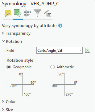
Target annotation layers will be rotated by calculating their
Anglefield (the default) or the angle information in theirElementBLOB field.The Input Map parameter value must have a projected coordinate system.
Paramètres
| Etiqueter | Explication | Type de données |
|---|---|---|
|
Input Map |
The map containing aviation features. |
Map |
|
Target Point or Annotation Layers |
The point or annotation feature layers that will be rotated. |
String |
|
Rotate Option (Facultatif) |
Specifies how the features will be rotated.
|
String |
Sortie dérivée
| Etiqueter | Explication | Type de données |
|---|---|---|
|
Updated Layers |
The feature layer with updated rotation values. |
Feature Layer |
Environnements
Cet outil n’utilise pas d’environnement de géotraitement.
Informations de licence
- Basic: No
- Standard: Requires ArcGIS Aviation Charting
- Advanced: Requires ArcGIS Aviation Charting