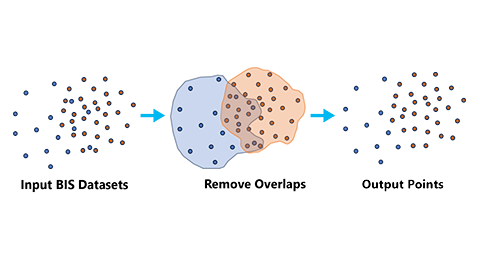
Exports a point or multipoint feature class from input points, multipoints, shapefile points, LAS, or LASD registered to a Bathymetric Information System (BIS). Exported features will comply with filters and ordering provided by an optional input query file, and dataset overlaps can be removed.
図
Overlaps in point data can be removed with the Remove overlaps parameter.
使用法
The Input BisCatalog parameter value must be a catalog dataset in a BIS workspace.
The Output Points parameter value must be a point or multipoint feature class in a file or enterprise geodatabase.
The Output Points parameter value must be a point or multipoint feature class in a non-BIS workspace.
Only point shapefiles and point feature classes will export as point feature classes. Other input data types will be ignored in a point feature class output.
If the input data includes any point cloud datasets, the output must be multipoint; otherwise, only point data will be exported and the point cloud data will be ignored.
注意:
When the Remove overlaps parameter is checked, overlaps will be assessed based on the dataset footprints. Depending on the type of footprint (envelope, convex hull, or precise) and the density of the datasets, unexpected removal may occur, particularly where overlaps encompass large areas. To prevent such removal, manually edit the footprints or use the Replace Footprints tool provided in the ArcGIS Bathymetry product data files to assign custom footprints to datasets in the BIS.
The catalog dataset in the BIS workspace that contains the point datasets that will be exported.
Feature Layer
Output Points
The output feature class that will be created. The output feature class will use the coordinate system of the BIS.
Feature Class
Data Type
(オプション)
Specifies the data type of the output.
Point—The output will be a new point feature class with the exported points. This is the default.
Multipoint—The output will be a new multipoint feature class with the exported points.
String
Query File (Filter, Rule, Model)
(オプション)
The file that will be used to determine which point datasets will be exported and the order of the output.
Filter file (*.filter)—This file filters the set of points that will be exported from the BisCatalog to the output. The output will follow the default OBJECTID ordering.
Rule file (*.rule)—This file establishes the sorting rules for the output data. All points in the BisCatalog will be exported to the output according to the defined rules.
Model file (*.model)—This file defines the specific set of point datasets to be exported from the BisCatalog to the output, along with the desired order of the output.
If no query file is provided, all points from the BisCatalog will be exported to the output using the default OBJECTID ordering.
File
Include dataset fields
(オプション)
Specifies whether the fields from the input point feature class items will be included in the output point feature class. This parameter only applies to point feature class output.
オン—All fields from the input point feature classes or shapefiles will be included in the output point feature class.
オフ—Only point geometries will be included in the output point feature class. This is the default.
Boolean
Remove overlaps
(オプション)
Specifies whether overlapping areas across the input point datasets will be exported to the output. In areas of overlap between two or more datasets, only points from the topmost dataset will be exported.
オン—Nonoverlapping point features representing the area where footprints overlapped will be exported.
オフ—Point features will be exported as-is, with all points retained in the output. This is the default.
The catalog dataset in the BIS workspace that contains the point datasets that will be exported.
Feature Layer
out_points
The output feature class that will be created. The output feature class will use the coordinate system of the BIS.
Feature Class
data_type
(オプション)
Specifies the data type of the output.
POINT—The output will be a new point feature class with the exported points. This is the default.
MULTIPOINT—The output will be a new multipoint feature class with the exported points.
String
in_query_file
(オプション)
The file that will be used to determine which point datasets will be exported and the order of the output.
Filter file (*.filter)—This file filters the set of points that will be exported from the BisCatalog to the output. The output will follow the default OBJECTID ordering.
Rule file (*.rule)—This file establishes the sorting rules for the output data. All points in the BisCatalog will be exported to the output according to the defined rules.
Model file (*.model)—This file defines the specific set of point datasets to be exported from the BisCatalog to the output, along with the desired order of the output.
If no query file is provided, all points from the BisCatalog will be exported to the output using the default OBJECTID ordering.
File
include_fields
(オプション)
Specifies whether the fields from the input point feature class items will be included in the output point feature class. This parameter only applies to point feature class output.
INCLUDE_FIELDS—All fields from the input point feature classes or shapefiles will be included in the output point feature class.
NO_INCLUDE_FIELDS—Only point geometries will be included in the output point feature class. This is the default.
Boolean
remove_overlaps
(オプション)
Specifies whether overlapping areas across the input point datasets will be exported to the output. In areas of overlap between two or more datasets, only points from the topmost dataset will be exported.
REMOVE_OVERLAPS—Nonoverlapping point features representing the area where footprints overlapped will be exported.
NO_REMOVE_OVERLAPS—Point features will be exported as-is, with all points retained in the output. This is the default.
Boolean
コードのサンプル
ExportBISPoints example (stand-alone script)
The following stand-alone script demonstrates how to use the ExportBISPoints function.