ArcGIS AllSource user interface
ArcGIS AllSource is an intelligence desktop application designed to analyze and visualize disparate data in both connected and disconnected environments. The sections below contain information to help familiarize users with the ArcGIS AllSource tabs, panes, and controls.
Sign in
The first time you use ArcGIS AllSource, you sign in with the credentials of your ArcGIS Online or ArcGIS Enterprise organization. After that, you are signed in automatically.
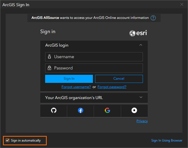
In ArcGIS AllSource, the sign-in menu is available on the start page and at the top of the application window. If you have more than one account, you can sign out of one and in to another to access content from a different portal or share items to a different portal.
Home page
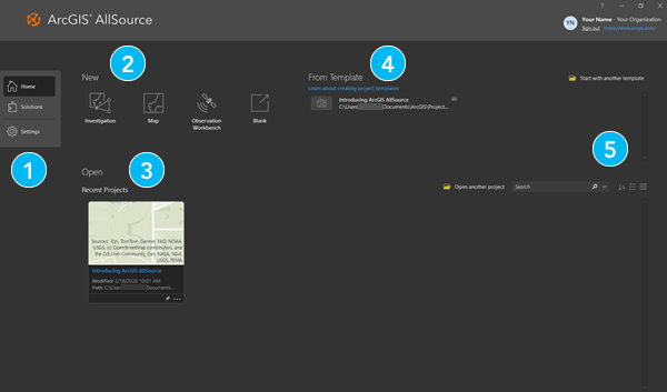
On start up, ArcGIS AllSource opens to the Home  page. The Home page is where you will create projects, open projects, and open templates.
|
Element |
Description |
|---|---|
|
|
Navigate between the Home
|
|
|
Click a default template to start a new project. |
|
|
Click a recent project to open it. To open a project that's not in the list, click Open another project
|
|
|
Click a recent template to start a new project from a custom template. To start a new project from a template that's not in the list, click Open another template |
|
|
Click List |


 .
.

 or Tiles
  to display projects according to your preference.
Solutions page
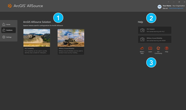
The Solutions  page holds templated projects ready to begin a new workflow. These solutions can be used in both connected and disconnected environments with help documentation and application resources to help get started.
|
Element |
Description |
|---|---|
|
|
Click a default template to start a new project. |
|
|
Click a card to open the associated help. |
|
|
Learn about ArcGIS AllSource workflows, join discussions in the Esri Community, and launch the local help system. |
Projects
In ArcGIS AllSource, a project is a body of related work that may include maps, scenes, layouts, and connections to resources such as system folders and databases. Project files have the extension .asrx. By default, a project is stored in its own folder along with an associated file geodatabase and toolbox.
Settings
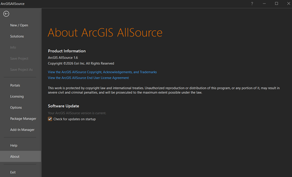
On the Settings tab  , you can configure and manage the application. In an open project, the settings can also be accessed from the Project tab on the ribbon.
|
Tab |
Description |
|---|---|
|
New |
Create a project. |
|
Open |
Open an existing project. |
|
Solutions |
Open the Solutions page. |
|
Info |
View info for the current project. |
|
Save Project |
Save the current project. |
|
Save Project As |
Save a copy of the current project file ( |
|
Portals |
Manage portal connections and set the active portal. |
|
Licensing |
View license information, authorize ArcGIS AllSource to work offline, and change the license type. |
|
Options |
Access project and application options to configure ArcGIS AllSource. |
|
Package Manager |
Manage environments and packages for Python, R, and system libraries. |
|
Add-In Manager |
Install add-ins to customize the application. |
|
Help |
Open the help system. |
|
About |
View information about your ArcGIS AllSource version. |
|
Learning Resources |
Access quick-start tutorials, tutorial series, and other learning resources. |
|
Exit |
Close the application. |
Resources
Extend your understanding and knowledge of ArcGIS AllSource with the following:
ArcGIS tutorials—Explore training and tutorials.
Esri Community—Connect to other users. Post questions, suggest ideas, and read ArcGIS Blog topics.
Help—Launch help viewer to learn more about ArcGIS AllSource.
Note:
Access to ArcGIS tutorials and Esri Community requires an internet connection.
ArcGIS AllSource user interface
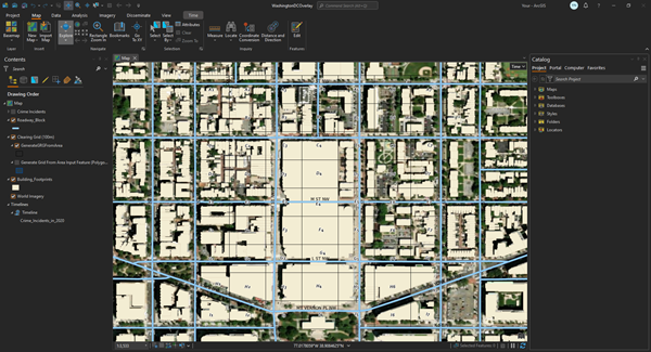
The main parts of the ArcGIS AllSource interface are the ribbon, views, and panes.
Ribbon
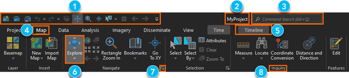
A horizontal ribbon at the top of the application window organizes functionality in a series of tabs. Some tabs (core tabs) are always present. Others (contextual tabs) appear when the application is in a particular state. For example, a Timeline contextual tab appears when a timeline is active in the application.
|
Element |
Description |
|---|---|
|
|
The Quick Access Toolbar has commonly used commands. |
|
|
The name of the project appears at the top of the application. |
|
|
Command Search helps you find and run commands. |
|
|
Core tabs, such as the Map tab, organize functionality. When a tab is selected, its associated tools and buttons appear on the ribbon. |
|
|
Contextual tabs, such as the Timeline tab, appear when the application is in a state appropriate for their use. |
|
|
Buttons and tools run commands. For example, you use the Explore tool to navigate maps and scenes and to identify map features. |
|
|
Dialog box launchers open panes or dialog boxes with more functionality. |
|
|
Groups organize related commands on a ribbon tab. |


Views
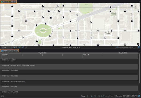
Views are windows for working with maps, scenes, timelines, layouts, tables, charts, the catalog, and other representations of your data. Several views can be open at the same time.
Panes
A pane is a window that displays the contents of a view (the Contents pane), the items in your project or active portal (the Catalog pane), or commands and settings for an area of functionality (the Symbology pane, the Geoprocessing pane, and so on).
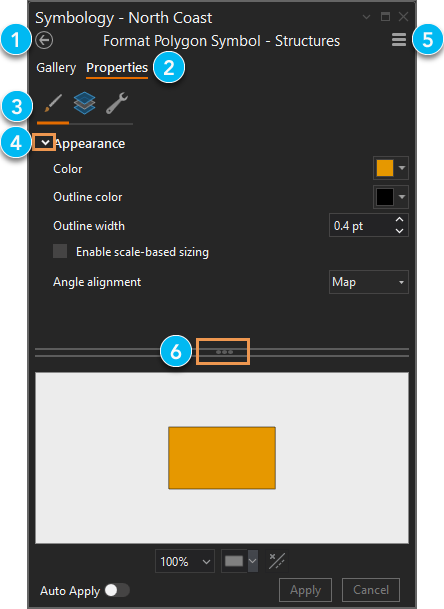
Panes provide functionality that may not be available on the ribbon. Panes may have rows of text tabs and graphical tabs to organize functionality. Some panes have multiple pages.
|
Element |
Description |
|---|---|
|
|
Some panes have multiple pages of functionality. |
|
|
Text-based primary tabs, such as Gallery and Properties, partition functionality. |
|
|
Graphical secondary tabs partition the functionality of a primary tab. |
|
|
Expanders are small arrows that you click to show or hide settings. |
|
|
The Menu button |
|
|
Handles allow you to resize areas of a pane by dragging. |
 has additional commands.
The Contents and Catalog panes are usually open in a project. Other panes appear in response to commands or actions. For example, when you click Locate  on the Map tab on the ribbon, the Locate pane appears.
You can close panes or leave them open. If a pane is open when you close ArcGIS AllSource, it will be open when you restart the application. You can manage some panes on the View tab on the ribbon. For example, you can click Reset Panes  to choose a specific pane configuration.
Arrange the user interface
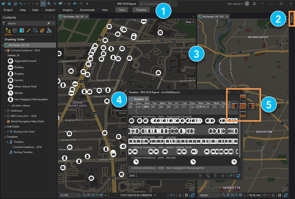
You can arrange the elements of the user interface in various ways:
Drag panes and views to docking targets.
Stack panes and views on top of one another.
Float panes and views above or away from the application window.
Divide view space into vertical or horizontal tab groups to display more views.
|
Element |
Action |
Method |
|---|---|---|
|
|
Minimize the ribbon. |
Press Ctrl+F1. |
|
|
Automatically hide a pane to minimize it when not in use. |
Click Auto-Hide |
|
|
Make a new tab group to divide view space. |
Right-click a view tab or press Alt+Hyphen for options. |
|
|
Float a view. |
Drag a view by its tab and drop it away from docking targets. Alternatively, right-click the view tab or press Alt+Hyphen for options. |
|
|
Dock a view. |
Drag a view by its tab and drop it on one of the docking targets that appear. Alternatively, right-click the view tab or press Alt+Hyphen for options. |
 in the pane's title bar. Alternatively, press Alt+Minus Sign for options.