Topographic Production Service
License:
To use this resource, an ArcGIS GIS Server Advanced license and an ArcGIS Topographic Mapping server extension license are required.
Topographic Production Service is a server object extension (SOE) to a map service. It allows you to perform topographic production capabilities on the map service, such as producing topographic maps based on industry-standard map product specifications.
Learn more about Topographic Production Service
Learn more about ArcGIS Server Services Directory
Publish the service
The Topographic Mapping extension in ArcGIS Pro allows you to publish Topographic Production Service.
Configure operations and properties
After you publish the service with the Topographic Production capability enabled, you can access the service operations and properties in the item settings in your organization or in ArcGIS Server Manager.
Access in the organization
Publishing the service creates a map image layer in your organization.
Important:
The Topographic Production operations and properties only appear for map image layers that you publish with the Topographic Production capability enabled and configured to use a dedicated instance. Map image layers that are published as shared instances do not expose these operations or properties in your organization.
Complete the following steps to access the service operations and properties in your organization:
Sign in to the organization as an administrator or as the map image layer item owner.
Open the item details page for the layer.
Click Settings.
In the Topographic production section, turn on the Configuration toggle button if necessary.
The Operations and Properties subsections appear.
Turn an operation's toggle button on to make the operation available.
Review or update the service properties:
In the Topographic production database text box, update the path to a spatial database engine (SDE) connection file.
In the Product type text box, update the types of products that are available.
In the Workflow item identifier text box, update the ID for the workflow item associated with the service.
Caution:
This is a required value if you are running topographic workflows that involve ArcGIS Workflow Manager. Workflow jobs fail to return workflow products if a value is not provided.
In the Workflow local job folder text box, update the path to the local folder where workflow jobs are stored.
Caution:
This is a required value if you are running topographic workflows that involve ArcGIS Workflow Manager. Download jobs fail if a value is not provided.
In the Extraction timeout text box, update how many seconds the data extraction can run before timing out.
The default value is 900 seconds.
Check or uncheck the Auto update products check box to specify whether the service automatically updates existing map product definitions.
Click Save.
The Save edits dialog box appears and asks whether you want to save and restart the service.
Click Save and restart to confirm or Cancel to continue making changes.
If you click Save and restart, the Save edits dialog box closes and the service restarts with your saved changes. If you click Cancel, the Save edits dialog box closes.
Access in ArcGIS Server Manager
In Server Manager, you can access the settings for a service, including its capabilities and properties, and make changes.
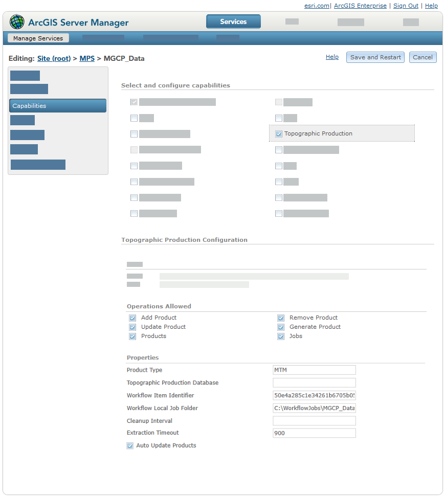
Complete the following steps in Server Manager to configure, review, or update a service's capabilities or properties:
Sign in to Server Manager.
If you don't see a list of services, click Services > Manage Services.
Click the map service that you want to enable topographic production capabilities on.
Click Capabilities.
Click Topographic Production.
The Topographic Production Configuration section appears.
Check the check boxes for the operations that you want for the service.
Review or update properties for the service.
In the Product Type text box, update the types of products that are available.
In the Topographic Production Database text box, update the path to a spatial database engine (SDE) connection file.
In the Workflow Item Identifier text box, update the ID for the workflow item associated with the service.
Caution:
This is a required value if you are running topographic workflows that involve ArcGIS Workflow Manager. Workflow jobs fail to return workflow products if a value is not provided.
In the Workflow Local Job Folder text box, update the path to the local folder where workflow jobs are stored.
Caution:
This is a required value if you are running topographic workflows that involve ArcGIS Workflow Manager. Download jobs fail if a value is not provided.
In the Extraction timeout text box, update how many seconds the data extraction can run before timing out.
The default value is 900.
Check or uncheck the Auto Update Products check box to specify whether the service automatically updates existing map product definitions.
Click Save and restart to confirm or Cancel to continue making changes.
Topographic Production Database
Topographic Production Service references a geodatabase through the tmserverDatabase property. This property is labeled Topographic Production Database in ArcGIS Server Manager.
Important:
This is a dedicated enterprise geodatabase that stores and manages operational information such as jobs, job history, products, workflow components, and other service-related data. It is not the production data geodatabase that contains the source feature data that Topographic Production Service publishes, edits, queries, and exposes through the REST API.
Provide one of the following to specify the geodatabase:
- Path to a spatial database engine (SDE) connection file—For example,
C:\Data\ConnectionFiles\<File Name>.sde
- Path to a spatial database engine (SDE) connection file—For example,
/opt/arcgis/ConnectionFiles/<File Name>.sde
Note:
In Server Manager, this path can be specified in the Topographic Production Database text box. The ArcGIS Server account must have read access to the location of the .sde connection file. The path can also be specified when Topographic Production Service is published in ArcGIS Pro using the tmserverDatabase text box.
Learn more about publishing Topographic Production Service in ArcGIS Pro
Registered database (user-managed)—Specify one of the following:
The name of the registered database
The data item path value of the registered database, for example,
/enterpriseDatabases/<registered_database_name>.Important:
The data item path is case-sensitive. To copy an exact value, sign in to the ArcGIS Server Administrator Directory and browse to data > items > enterpriseDatabases and choose the registered database. The path property in the response is the value to copy and paste. Alternatively, use the Data Item REST API endpoint.
This geodatabase contains multiple tables and includes additional database objects for task and control workflows:
TPS_WORKTASKstores work task records. Therun_contextfield stores task execution context information in JSON format.TPS_CONTROL_STATEstores key/value control state information used by distributed topographic services.TPS_WORKTASK_VIEWprovides a consolidated view of related work and task records for query workflows.
Jobs table
Key job properties are stored in TPS_JOB table dedicated fields to improve query performance and simplify integration with reporting workflows.
jobName—stores the job name.parentJobId—stores the parent job reference that is used by topographic production workflow jobs.productName—stores the job's specified map product name.productVersionstores the job's specified map product version.
Existing values are extracted from job parameters and written to these fields.
Properties table
The TPS_PROPERTY table contains the properties that are defined when the service is published from ArcGIS Pro and can be accessed from ArcGIS Server Manager after the service is published. This table also stores properties for each service that is published with the topographic production SOE enabled. It contains the following properties:
ObjectIDServiceIdentifierNameValue
Note:
The ServiceIdentifier column contains the service's unique ID. If the value of the ID is -1, the property is a global property that applies to all services.
Each row in the TPS_PROPERTY table is a property. The following table describes each property:
|
Property |
Description |
|---|---|
|
|
|
|
|
A global property that allows a group of users to cancel or delete jobs in the web apps included with the ArcGIS Topographic Mapping server extension. To provide a group with these privileges, update the In a stand-alone ArcGIS Server deployment, you can assign these privileges to a group by providing the role name value of a user with an ArcGIS Server administrator role type as the value for this property. |
|
|
The SDE authentication mode that is allowed. The following are supported: Caution:Changing the mode by updating this value poses a security risk. Changing this setting is not recommended.
|
|
|
A list of services that are outside of the federated environment that an organization has deemed safe. This list should only contain public services and can be comma-separated values. The service URL structure impacts which services are allowed. For example:
|
|
|
Specifies whether the service uses public or private urls.
|
|
|
Specifies whether updates to the map product definitions—made in the
|
|
|
The number of hours before temporary data used to produce a map product and the output map products are deleted from the server. The default is |
|
|
Note:This property applies to Linux only. If the product files are not located at the default installation location, provide the path to their location. |
|
|
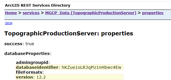
The unique database ID. This is stored internally and cannot be modified throughout the lifespan of the geodatabase. The TopographicProductionServer properties REST resource also exposes the database identifier and version values:
|
|
|
The date and time format when a token involving date or time is used in a job output file name. |
|
|
The size, in kilobytes, of each chunk used when job output is downloaded from the server. |
|
|
Specifies whether a job's progress is updated while data is extracted for the job. The default is Tip:When working with high-volume deployments, a value of |
|
|
The amount of time in seconds that the data extraction can run before timing out. |
|
|
Note:This is a global property, set the The following are supported file types:
The following tokens can be used to define a job output file name:
If the format is missing the file type extension, it is automatically appended. Caution:Include the [JobId] token, [JobStartDate] token, or both to help avoid file name conflicts. |
|
|
The maximum number of jobs that a single user can download. |
|
|
The number of days that data related to map production jobs is stored in the database. The default is |
|
|
Note:This property applies to Linux only. The path to the local directory where temporary job data is stored. |
|
|
The date and time that the temporary data for a job was last deleted from the server. |
|
|
Note:This property applies to Linux only. If the product files are not directly installed on the machine, provide the path to them or the data store ID. |
|
|
The map product types supported by the service. Multiple values must be separated by a comma, for example: TM, JOG. Map product definitions have a |
|
|
A global property that specifies whether the default output folder for a job is named based on the job ID. The default is If the value is set to |
|
|
The version of the topographic server geodatabase. This value matches the current version of ArcGIS Enterprise. The TopographicProductionServer properties REST resource also exposes the database identifier and minor version values:
|
|
|
The ID string associated with a topographic production workflow item. |
|
|
The path to the location of a folder that contains the data for local jobs. |
Product output
Completed jobs return an output URL.
The output URL contains the following values:
An ID based on your organization
The deployment's service ID
The job ID
The job ID is the job's globally unique identifier (GUID) with the hyphens removed, preceded by a letter that identifies the job type:
M—Jobs submitted from the Map Production System (MPS) appW—Jobs submitted through topographic production workflowsI—Short-running internal jobs
Note:
The UseJobIdFolder property determines whether job IDs appear in the output URL. If the property is set to False, the jobStatus response does not contain job IDs.
Open the output URL to review the generated product. Review each product before you distribute it to confirm that it generated completely.