Storing referent and offset information for event location
 Available with the Linear Referencing license.
ArcGIS Linear Referencing can persist referent locations and measures with events, in addition to the route ID and measures. This is particularly useful for capturing the original location method for an event and for using the referent offset, instead of the route and measure, to locate events impacted by a cartographic realignment.
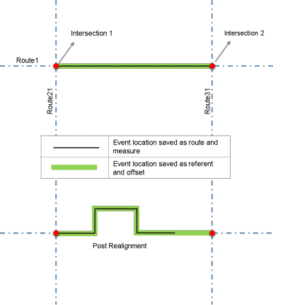
The following scenario applies a cartographic realignment to a segment of Route 1 between Intersection 1 and Intersection 2.
The route edit impacts two events differently according to the following event location methods used to store their measures:
Event location saved as route and measure—Measures remain intact after the edit although the measure length of the route increases and the resulting event does not touch Intersection 2. The event location changes relative to Intersection 2.
Event location saved as referent and offset—Measures change after the edit according to their relation to stored referent and offset values. The location of the intersections remains intact and the resulting event is still located between Intersection 1 and Intersection 2.
The following image shows how a realignment impacts an event located using route and measure (black line) differently than an event located using referent and offset (green line):
You can store referent locations using the following techniques:
Offset distance from any point feature in the geodatabase
Offset distance from an intersection point feature
Offset distance from a point event feature
Offset distance from an x,y coordinate
Offset distance from a station
To use referent and offset information, add fields to the event layer for the referent method, referent location, and referent offset. For line events, there are two sets of these fields: one for the start measure and one for the end measure. For point events, only one set of these fields is required.
Learn more about event referent fields in the linear referencing system (LRS) events data model
After you add these columns, you can enable them in the event using the Enable Referent Fields tool.
After you configure and enable referents for an LRS event, you can configure the Honor Referent Location event behavior for cartographic realignment using the Modify Event Behavior Rules tool.
The following table shows an example event layer attribute table that stores referent offset values:
| From Measure | FromRefMethod | FromRefLocation | FromRefOffset | To Measure | ToRefMethod | ToRefLocation | ToRefOffset |
|---|---|---|---|---|---|---|---|
| 0.26 | Intersections | {-6E5F} | 10 | 0.43 | Intersections | {-6E5F} | -26.2 |
| 0 | Intersections | {-6928} | 0 | 2.359 | X/Y | 468465.683, 361690.902 | 100 |
| 0.41 | Stations | 5 | -134.682 | 0.68 | Stations | 5 | 1+38.998 |
| 0 | Posts | 11 | -20 | 1 | Length | 6336 |
Event referent fields
The properties of the manually added referent and offset fields in an event layer are described in the following sections.
Referent method
The referent method field stores the methodology provided for referencing the event location. In addition, events in the same layer can have different referent methods. For example, one event in the layer can use an x,y coordinate offset while another event in the same layer can use an intersection and offset.
The referent method information is stored in a coded value domain named dReferentMethod in the geodatabase. This domain is created automatically when the LRS is created and has the following default values:
Code 0 for x,y location offset
Code 1 for length distance from a point location
Code 2 for stationing offset

The rest of the coded values are added automatically when you add a network, register a line or point event, create an LRS intersection feature class, or add a stationing event.
Note:
If you want to offset an event from a point feature class that is not part of the LRS (but present in the geodatabase), you need to manually add that feature class's code and description (name) into the
dReferentMethoddomain.You can edit the
dReferentMethoddomain in the Domains view.The domain stores the referent method as a coded value instead of the name of the feature class used for the referent feature. This means that if you rename the feature class, you don't need to update the event data.
Referent location
The referent location field stores the referent location information for locating the feature. The following table describes the type of information stored in this field:
| If the referent method is | The referent location field stores |
|---|---|
| Route ID and Measure | Measure |
| Intersection and Offset | Intersection ID. The intersection ID used as a referent location must be on the same route that the event is on. |
| Event ID and Offset | Event ID |
| Feature Class and Offset | Object ID. The object ID field must be set as the display field for the feature class in the feature service. |
| X,Y Coordinates | Comma-separated coordinates |
| A station measure (relative to a Station Event layer) | Referent station Event ID |
| Starting Station and Offset | Referent station Event ID |
Referent offset
The referent offset field stores the offset measure from the referent location. The following table describes the type of information stored in this field:
| If the referent method is | The referent offset field stores |
|---|---|
| Route ID and Measure | Measure |
| Intersection and Offset; Event and Offset; X,Y Coordinates; or Feature Class and Offset | Offset as a negative or positive value (compass directions provided by the user are translated to + or - offsets at storage) |
| A station measure (relative to a Station Event layer) or Starting Station and Offset | User-supplied station measure in the station format (for example, 100+22.65) |
You configure the units of measure for storage when you register the event layer.