Create Thiessen Polygons (Analysis Tools)
Summary
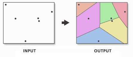
Creates Thiessen polygons from point features.
Each Thiessen polygon contains only a single point input feature. Any location within a Thiessen polygon is closer to its associated point than to any other point input feature.
Illustration
Usage
This tool is used to divide the area covered by the input point features into Thiessen or proximal zones. These zones represent full areas where any location within the zone is closer to its associated input point than to any other input point.
Dive in:
The theoretical background for creating Thiessen polygons is as follows:
Where S is a set of points in coordinate or Euclidean space (x,y), for any point p in that space, there is one point of S closest to p, except where point p is equidistant to two or more points of S.
A single proximal polygon (Voronoi cell) is defined by all points p closest to a single point in S, that is, the total area in which all points p are closer to a given point in S than to any other point in S.
Thiessen proximal polygons are constructed as follows:
All points are triangulated into a triangulated irregular network (TIN) that meets the Delaunay criterion.
The perpendicular bisectors for each triangle edge are generated, forming the edges of the Thiessen polygons. The location at which the bisectors intersect determine the locations of the Thiessen polygon vertices.
The outside boundary of the output Thiessen polygon feature class is the extent of the point input features plus an additional 10%. If the Extent environment is set to a specific extent window, this tool tool will use the environment setting to set its outside boundary.
Caution:
This tool may produce unexpected results with data in a geographic coordinate system since the Delaunay triangulation method used by the tool works best with data in a projected coordinate system.
Parameters
| Label | Explanation | Data type |
|---|---|---|
|
Input Features |
The point input features from which Thiessen polygons will be generated. |
Feature Layer |
|
Output Feature Class |
The output feature class containing the Thiessen polygons that are generated from the point input features. |
Feature Class |
|
Output Fields (Optional) |
Specifies which fields from the input features will be transferred to the output feature class.
|
String |
Environments
Default Output Z Value, M Resolution, M Tolerance, Output M Domain, Output XY Domain, Output Z Domain, Output Coordinate System, Extent, Current Workspace, Geographic Transformations, Scratch Workspace, Output has M values, Output has Z values, Z Resolution, Z Tolerance, XY Tolerance, XY Resolution
Licensing information
- Basic: No
- Standard: No
- Advanced: Yes