Clip Layer (GeoAnalytics Server Tools)
Summary
Extracts input features from within specified polygons.
Legacy:
The ArcGIS GeoAnalytics Server extension is being deprecated in ArcGIS Enterprise. The final release of GeoAnalytics Server was included with ArcGIS Enterprise 11.3. This geoprocessing tool is available through ArcGIS Enterprise 11.3 and earlier versions.
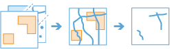
Illustration
Usage
Use Clip Layer to clip point, line, or polygon features.
Use this tool to cut out a piece of a feature class using one or more of the features from another feature class as a cookie cutter. This is particularly useful for creating a feature class—also referred to as a study area or an area of interest (AOI)—that contains a geographic subset of the features from another, larger feature class.
The analysis will clip features or portions of features that overlay the areas of interest.
The output result will contain input layer features that overlay clip layer polygons.
The output geometry type will be the same as the input features being clipped. For example, if you clip line features within a polygon, the output result will be lines.
All fields from the Input Layer parameter will be included in the output result. Fields from the Clip Layer parameter will not be included in the output.
You can improve performance of the Clip Layer tool by doing one or both of the following:
Set the extent environment so that you only analyze data of interest.
Use data that is local to where the analysis is being run.
This geoprocessing tool is powered by ArcGIS GeoAnalytics Server. Analysis is completed on GeoAnalytics Server, and results are stored in your content in ArcGIS Enterprise.
When running GeoAnalytics Server tools, the analysis is completed on GeoAnalytics Server. For optimal performance, make data available to GeoAnalytics Server through feature layers hosted on your ArcGIS Enterprise portal or through big data file shares. Data that is not local to GeoAnalytics Server will be moved to GeoAnalytics Server before analysis begins. This means that it will take longer to run a tool and, in some cases, moving the data from ArcGIS Pro to GeoAnalytics Server may fail. The threshold for failure depends on your network speeds, as well as the size and complexity of the data. It is recommended that you always share your data or create a big data file share.
Learn more about sharing data to your portal
Learn more about creating a big data file share through Server Manager
Parameters
| Label | Explanation | Data type |
|---|---|---|
|
Input Layer |
The dataset containing the point, line, or polygon features to be clipped. |
Feature Set |
|
Clip Layer |
The dataset containing the polygon features used to clip the input features. |
Feature Set |
|
Output Name (Optional) |
The name of the output feature service. |
String |
|
Data Store (Optional) |
Specifies the ArcGIS Data Store where the output will be stored. All results stored in a spatiotemporal big data store will be stored in WGS84. Results stored in a relational data store will maintain their coordinate system.
|
String |
Derived output
| Label | Explanation | Data type |
|---|---|---|
|
Output Feature Class |
The clipped output. |
Feature Set |
Environments
Output Coordinate System, Extent, Current Workspace
Special cases
- Output Coordinate System
-
The coordinate system that will be used for analysis. Analysis will be completed in the input coordinate system unless specified by this parameter. For GeoAnalytics Tools, final results will be stored in the spatiotemporal data store in WGS84.
Licensing information
- Basic: Requires ArcGIS GeoAnalytics Server
Available with ArcGIS Enterprise 10.7 - Standard: Requires ArcGIS GeoAnalytics Server
Available with ArcGIS Enterprise 10.7 - Advanced: Requires ArcGIS GeoAnalytics Server
Available with ArcGIS Enterprise 10.7