Add XY Coordinates (Data Management Tools)
Summary
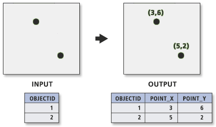
Adds the fields POINT_X and POINT_Y to the point input features and calculates their values. The tool also appends the POINT_Z and POINT_M fields if the input features are z- and m-enabled.
Illustration
Usage
Caution:
This tool modifies the input data. See Tools that modify or update the input data for more information and strategies to avoid undesired data changes.
If the
POINT_X,POINT_Y,POINT_Z, andPOINT_Mfields exist, their values are recalculated.The output
POINT_XandPOINT_Yfield values are based on the coordinate system of the dataset, not the coordinate system of the map display. To force thePOINT_XandPOINT_Yvalues to be in a coordinate system different than the input dataset, set the Output Coordinate System environment.If points are moved after using Add XY Coordinates, their
POINT_XandPOINT_Yvalues, andPOINT_ZandPOINT_Mvalues—if present—must be recomputed by running Add XY Coordinates again.The Project tool does not modify the values of
POINT_X,POINT_Y,POINT_Z, orPOINT_Mfields.If the input features are in a geographic coordinate system,
POINT_XandPOINT_Yrepresent the longitude and latitude, respectively.
Parameters
| Label | Explanation | Data type |
|---|---|---|
|
Input Features |
The point features whose x,y coordinates will be appended as |
Feature Layer |
Derived output
| Label | Explanation | Data type |
|---|---|---|
|
Updated Input Features |
The updated input features. |
Feature Layer |
Environments
Current Workspace, Extent, Output Coordinate System, Geographic Transformations
Licensing information
- Basic: Yes
- Standard: Yes
- Advanced: Yes