ACosH (Spatial Analyst Tools)
Summary
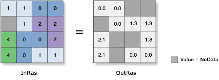
Calculates the inverse hyperbolic cosine of cells in a raster.
Illustration
Usage
In mathematics, all trigonometric functions have a defined range of valid input values called the domain. The output values from each function also have a defined range. For this tool, the following are true:
The Domain is: 1 ≤ [in_value] < ∞
Note that any input value that is outside this domain will receive NoData on the output raster.
The Range is: -∞ < [out_value] < ∞
Note that -∞ and ∞ represent the smallest negative and largest positive values supported by the particular raster format, respectively.
The input and output values for this tool are interpreted as unitless.
Output values are always floating point, regardless of the input data type.
If the input is a multiband raster, the output will be a multiband raster. The tool will perform the operation on each band in the input.
If the input is multidimensional raster data, all slices from all variables will be processed. The output will be a multidimensional raster in CRF format.
See Analysis environments and Spatial Analyst for additional details on the geoprocessing environments that apply to this tool.
Parameters
| Label | Explanation | Data type |
|---|---|---|
|
Input raster or constant value |
The input for which to calculate the inverse hyperbolic cosine values. To use a number as an input for this parameter, the cell size and extent must first be set in the environment. |
Raster Layer; Constant |
Return value
| Label | Explanation | Data type |
|---|---|---|
|
Output raster |
The output raster. The values are the inverse hyperbolic cosine of the input values. |
Raster |
Environments
Auto Commit, Cell Size, Cell Size Projection Method, Current Workspace, Extent, Geographic Transformations, Mask, Output CONFIG Keyword, Output Coordinate System, Scratch Workspace, Snap Raster, Tile Size
Licensing information
- Basic: Requires Spatial Analyst or Image Analyst
- Standard: Requires Spatial Analyst or Image Analyst
- Advanced: Requires Spatial Analyst or Image Analyst