Combinatorial And (Spatial Analyst Tools)
Summary
Performs a Combinatorial And operation on the cell values of two input rasters.
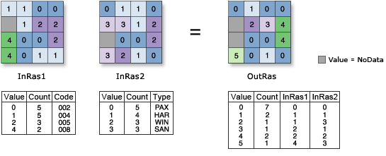
If both input values are true (non-zero), the output is a different value for each unique combination of input values. If one or both inputs are false (zero), the output value is 0.
Illustration
Usage
The Combinatorial math tools interpret the inputs as Boolean values in which nonzero values are considered true and zero is considered false.
Two inputs are necessary for this combinatorial evaluation to take place.
The order of inputs for this tool is only relevant for the output attribute table.
See Analysis environments and Spatial Analyst for additional details on the geoprocessing environments that apply to this tool.
Parameters
| Label | Explanation | Data type |
|---|---|---|
|
Input raster or constant value 1 |
The first input to use in this combinatorial operation. It must be of integer type. A number can be used as an input for this parameter, provided a raster is specified for the other parameter. To specify a number for both inputs, the cell size and extent must first be set in the environment. |
Raster Layer; Constant |
|
Input raster or constant value 2 |
The second input to use in this combinatorial operation. It must be of integer type. A number can be used as an input for this parameter, provided a raster is specified for the other parameter. To specify a number for both inputs, the cell size and extent must first be set in the environment. |
Raster Layer; Constant |
Return value
| Label | Explanation | Data type |
|---|---|---|
|
Output raster |
The output raster. The output is always of integer type. |
Raster |
Environments
Auto Commit, Cell Size, Cell Size Projection Method, Compression, Current Workspace, Extent, Geographic Transformations, Mask, Output CONFIG Keyword, Output Coordinate System, Scratch Workspace, Snap Raster, Tile Size
Licensing information
- Basic: Requires Spatial Analyst or Image Analyst
- Standard: Requires Spatial Analyst or Image Analyst
- Advanced: Requires Spatial Analyst or Image Analyst