Lowest Position (Spatial Analyst Tools)
Summary
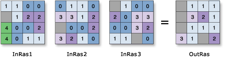
Determines on a cell-by-cell basis the position of the raster with the minimum value in a set of rasters.
Illustration
Usage
An arbitrary number of rasters can be specified in the input rasters list.
The order of the input rasters is relevant for this tool.
When a multiband raster is specified as one of the Input rasters or constant values parameter values (
in_rasters_or_constantsin Python), all the bands will be used.To process a selection of bands from a multiband raster, first create a raster dataset composed of those particular bands using the Composite Bands tool; then use the result in the list in the Input rasters or constant values parameter (
in_rasters_or_constantsin Python).If a cell location contains NoData on any of the input rasters, that location will be assigned NoData on the output.
The output raster is always of integer type.
If two or more input rasters contain the minimum value for a particular cell location, the position of the first one encountered is returned on the output raster.
If all inputs are multidimensional raster data with the same number of variables, the tool will perform the operation for all slices with the same dimension value. The output will be a multidimensional raster in CRF format. The variables in the inputs must have at least one common dimension and one common dimensional value for this tool to process, otherwise an error will occur.
If all of the inputs have one variable but different names, uncheck the Match Multidimensional Variable geoprocessing environment (set
arcpy.env.matchMultidimensionalVariable = Falsein Python) before performing the operation.If one or more of the inputs are multidimensional rasters and the other inputs are constant, the tool will perform the operation for all slices for all variables using the constant value, and the output will be a multidimensional raster.
See Analysis environments and Spatial Analyst for additional details on the geoprocessing environments that apply to this tool.
Parameters
| Label | Explanation | Data type |
|---|---|---|
|
Input rasters or constant values |
The list of input rasters for which the position of the input with the lowest value will be determined. A number can be used as an input; however, the cell size and extent must first be set in the environment. |
Raster Layer; Constant |
Return value
| Label | Explanation | Data type |
|---|---|---|
|
Output raster |
The output raster. For each cell in the output raster, the value represents the position of the raster with the lowest value. |
Raster |
Environments
Auto Commit, Cell Size, Cell Size Projection Method, Compression, Current Workspace, Extent, Geographic Transformations, Mask, Output CONFIG Keyword, Output Coordinate System, Scratch Workspace, Snap Raster, Tile Size
Licensing information
- Basic: Requires Spatial Analyst
- Standard: Requires Spatial Analyst
- Advanced: Requires Spatial Analyst