3D ポリゴンは、フィーチャの輪郭に沿った標高値のみを含みます。ポリゴンの内部には頂点が存在しません。 3D を塗りつぶしで描画する場合、境界の頂点はレンダリング用の三角形に任意で接続されます。 ポリゴンが平面 (傾斜または水平) でない場合、内側サーフェスの塗りつぶしは正しく描画されないことがほとんどです。 このため、非平面 3D ポリゴンは塗りつぶしシンボルを使用せずに描画することを推奨します。
'''*********************************************************************
Name: RasterDomain Example
Description: This script demonstrates how to use the
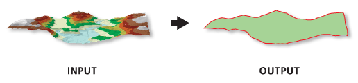
             Raster Domain tool to generate polygon footprints for all
             *.img rasters in a given workspace.
**********************************************************************'''

# Import system modules
import arcpy

# Set environment settings
arcpy.env.workspace = "C:/data"

# Create the list of IMG rasters
rasterList = arcpy.ListRasters("*", "IMG")
# Verify there are rasters in the list
if rasterList:
    # Loop the process for each raster
    for raster in rasterList:
        # Set Local Variables
        outGeom = "POLYGON" # output geometry type
        # The [:-4] strips the .img from the raster name
        outPoly = "domain_" + raster[:-4] + ".shp"
        print("Creating footprint polygon for " + raster + ".")
        # Run RasterDomain
        arcpy.ddd.RasterDomain(raster, outPoly, outGeom)
    print("Finished.")
else:
    print("There are no IMG files in the " + env.workspace + " directory.")