道路距離/時間商圏の生成 (Business Analyst ツール)
サマリー
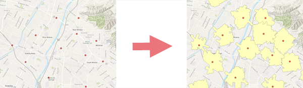
ポイント フィーチャの周囲に、移動時間および距離に基づいて商圏のフィーチャクラスを作成します。
図
使用法
このツールを使用するには、ローカルに保存されたデータセット、または ArcGIS Online などのポータル接続が必要です。
さまざまな移動モードを使用して、重複していない到達圏を作成することができます。
オーバーラップの削除 パラメーターを使用する場合は、フィーチャを 200 ~ 300 ポイント程度に制限してください。 大規模なサイト セットの場合は、まず重なり合うエリアを作成し、オーバーラップの除去 (複数) ツールを使用すると成功する可能性があります。
時刻 パラメーターを使用して、指定した日時の履歴交通量データに基づいて、出力ポリゴンをモデル化します。
ID フィールド パラメーターを使用して、各ポリゴンおよび各入力ポイントを一意に識別する出力内の属性を作成します。
パラメーター
| ラベル | 説明 | データ タイプ |
|---|---|---|
|
入力フィーチャ |
入力ポイント フィーチャ レイヤー。 |
Feature Layer |
|
出力フィーチャクラス |
到達圏ポリゴンが格納される出力フィーチャクラス。 |
Feature Class |
|
距離タイプ |
到達圏の計算に使用される移動方法。 |
String |
|
距離 |
到達圏の計算に使用される距離。 |
Double |
|
距離単位 (オプション) |
距離の値に使用される単位。 デフォルト値はマイルです。 |
String |
|
ID フィールド (オプション) |
既存施設の一意の ID フィールド。 |
Field |
|
ディゾルブ オプション (オプション) |
複数の距離を指定した場合に、1 つの位置で重複する到達圏を使用するのか、それとも重複しない到達圏を使用するのかを指定します。
|
String |
|
オーバーラップの削除 (オプション) |
重複する同心リングを作成するのか、それとも互いに重複する部分を複数の位置から削除するのかを指定します。
|
Boolean |
|
移動方向 (オプション) |
移動方向として、店舗に向かう方向、離れる方向を指定します。
|
String |
|
時刻 (オプション) |
距離を計算するときに使用される日時。 |
Date |
|
タイム ゾーン (オプション) |
時刻 パラメーターに使用されるタイム ゾーンを指定します。
|
String |
|
検索許容値 (オプション) |
入力ポイントが存在する可能性があるネットワークからの最大距離。 検索許容値を超える位置にあるポイントは、処理から除外されます。 このパラメーターは、許容値の距離値および単位を必要とします。 デフォルト値は 5000 メートルです。 |
Linear Unit |
|
ポリゴンの詳細 (オプション) |
出力到達圏ポリゴンに使用される詳細レベルを指定します。
|
String |
|
入力方法 (オプション) |
各到達圏に使用される値のタイプを指定します。
|
String |
|
距離の式 (オプション) |
到達圏の計算に使用するフィールドベースの式 |
SQL Expression |
環境
現在のワークスペース, データ ソース, ネットワーク ソース, 地理座標系変換
ライセンス情報
- Basic: Business Analyst と Network Analyst が必要
- Standard: Business Analyst と Network Analyst が必要
- Advanced: Business Analyst と Network Analyst が必要