擦除点 (编辑工具)
汇总
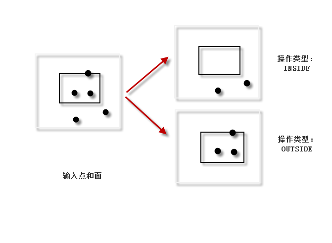
从输入中删除移除要素之内或之外的点,具体取决于操作类型。
插图
用法
参数
|
标注
|
说明
|
数据类型
|
|
输入要素
|
输入点要素。
|
Feature Layer
|
|
移除要素
|
将用于确定要从输入要素值中删除的要素的面要素。
|
Feature Layer
|
|
操作类型
(可选)
|
指定将删除移除要素内部还是外部的点。
|
String
|
派生输出
|
标注
|
说明
|
数据类型
|
|
更新的输入要素
|
更新后的输入要素。
|
Feature Class
|
arcpy.edit.ErasePoint(in_features, remove_features, {operation_type})
|
名称
|
说明
|
数据类型
|
|
in_features
|
输入点要素。
|
Feature Layer
|
|
remove_features
|
将用于确定要从 in_features 值中删除的要素的面要素。
|
Feature Layer
|
|
operation_type
(可选)
|
指定将删除移除要素内部还是外部的点。
|
String
|
派生输出
|
名称
|
说明
|
数据类型
|
|
out_feature_class
|
更新后的输入要素。
|
Feature Class
|
代码示例
ErasePoint 示例 1(Python 窗口)
以下 Python 窗口脚本演示了如何在即时模式下使用 ErasePoint 函数。
import arcpy
arcpy.env.workspace = "C:/data"
arcpy.edit.ErasePoint("trees.shp", "park_boundaries", "INSIDE")
以下独立脚本演示了如何使用 ErasePoint 函数。
# Name: ErasePoint_Example2.py
# Description: Replacing low resolution elevation points inside
# lake areas by high resolution lidar points.

# Import system modules
import arcpy

# Set environment settings
arcpy.env.workspace = "C:/data/Portland.gdb/relief"

# Set local variables
inElevationFeatures = "elevation_points"
inLidarFeatures = "lidar_points"
inLakeFeatures = "lakes"

# Erase elevation points inside lakes
arcpy.edit.ErasePoint(inElevationFeatures, inLakeFeatures, "INSIDE")

# Clip lidar points inside lakes
arcpy.edit.ErasePoint(inLidarFeatures, inLakeFeatures, "OUTSIDE")

# Append the clipped lidar points to the remaining elevation points
arcpy.management.Append(inElevationFeatures, inLidarFeatures, "NO_TEST")
环境
当前工作空间
许可信息