Set Maritime Chart Service properties
 Available with Advanced license.
Available with ArcGIS Maritime license.
The sections below describe how to configure the map service to run Maritime Chart Service.
Note:
Enable Maritime Chart Service before completing the following steps.
Add the Maritime Chart Service capability to a map service
To add the Maritime Chart Service capability to the map service, complete the steps below. Repeat these steps for each map service you plan to use with Maritime Chart Service.
Sign in to ArcGIS Server Manager.
Click Services > Manage Services.
Click the map service to which you want to add Maritime Chart Service.
Maritime Chart Service works with any existing map service.
Click Capabilities and check the Maritime Chart Service check box.
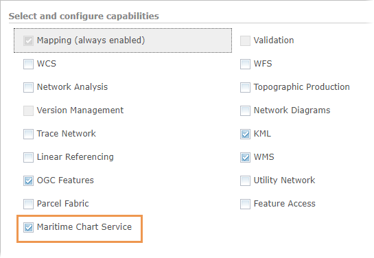
-
Under Properties, provide the
controlFilesDirectory,datasetsDirectory, andworkingDirectoryproperty paths.The default location for these folders is
C:\arcgisserver\directories\maritimeserver\maritimechartservice.Under Properties, provide the
controlFilesDirectory,datasetsDirectory, andworkingDirectoryproperty paths.The default location for these folders is
<ArcGIS Server installation directory>/usr/directories/maritimeserver/maritimechartservice. Click Save and Restart to restart the map service.
Maritime Chart Service capabilities are enabled.
The Maritime Chart Service configuration is complete and you can load S-57 datasets into the service. You can also configure the sample viewer. Download sample Experience Builder widgets for examples of how to use the Maritime Chart Service capability. Once Maritime Chart Service is enabled and configured, you can do the following:
Modify additional service properties.
Manage data for unencrypted S-57 datasets.
Manage data for S-63 encrypted datasets.
Run Maritime Chart Service on multiple map services.
Modify the Maritime Chart Service capabilities properties
There are three directory paths that allow various configurations of Maritime Chart Service: datasetsDirectory, controlFilesDirectory, and workingDirectory. These directory paths and the steps to modify them are explained in the following sections.
datasetsDirectory property
The datasetsDirectory property specifies the location of the datasets folder. The datasets folder is where you can store S-57 datasets—this can include exchange sets or individual .000 files, associated update files (.001, .002, and so on), and external (.txt and .tiff) files.
This location can be local to the map service or shared across a network path. The default location of the datasets folder is C:\arcgisserver\directories\maritimeserver\maritimechartservice.
This location can be local to the map service or shared across a network path. The default location of the datasets folder is <ArcGIS Server installation directory>/usr/directories/maritimeserver/maritimechartservice.
The datasets folder location can also be shared by more than one map service running Maritime Chart Service. Using a shared datasetsDirectory location allows you to set up multiple map services with only one set of data. By doing so, you can perform maintenance while providing multiple types of services. For example, a single set of S-57 datasets can be used to publish a full coverage ENC service and a navigational aids-only map service. There is no limit to the number of map services you can share S-57 datasets with.
controlFilesDirectory property
The controlFilesDirectory property specifies the location of the controlfiles folder. The controlfiles folder contains the S-57 data dictionary information and the S-52 presentation library. When the service starts and creates the .senc files, it references these control files.
This location can be local to the map service or shared across a network path. The default location of the controlfiles folder is C:\arcgisserver\directories\maritimeserver\maritimechartservice.
This location can be local to the map service or shared across a network path. The default location of the controlfiles folder is <ArcGIS Server installation directory>/usr/directories/maritimeserver/maritimechartservice.
You can keep the control files local to a map service while pointing to a single set of S-57 datasets. This allows you to configure multiple services with different default configuration settings. For example, you can use a single set of S-57 datasets to publish five different map services. Each service can have a separate default color scheme or list of exposed layers. Map service control files can be set to only show one layer, such as navigational aids, while another map service provides full ENC coverage.
workingDirectory property
The workingDirectory property specifies the location of two folders that the service accesses when it is started: the logs folder and the sencs folder. The logs folder contains time-stamped log files that are created when the map service is started or when AutoCellUpdate is used. The sencs folder contains the .senc files created by the service and the find.dat file.
Note:
Mapped network drives are not recommended for the working directory due to potential performance issues. Store the .senc files on the physical server.
The default location where the logs and sencs folders are stored is C:\arcgisserver\directories\maritimeserver\maritimechartservice.
The default location where the logs and sencs folders are stored is <ArcGIS Server installation directory>/usr/directories/maritimeserver/maritimechartservice.
Modify the directories
To modify the directories, complete the following steps:
Sign in to Server Manager if necessary.
Click Services > Manage Services.
Click the name of the map service with Maritime Chart Service capabilities enabled.
Click Capabilities.
In the Select and configure capabilities section, click Maritime Chart Service.
The Maritime Chart Service Configuration section appears.
In the Properties section, provide the
controlFilesDirectory,datasetsDirectory, andworkingDirectorypaths.Click Save and Restart.
The Maritime Chart Service properties are updated and applied to the map service.