Find Hot Spots (GeoAnalytics Server Tools)
Summary
Given a set of features, identifies statistically significant hot spots and cold spots using the Getis-Ord Gi* statistic.
Legacy:
The ArcGIS GeoAnalytics Server extension is being deprecated in ArcGIS Enterprise. The final release of GeoAnalytics Server was included with ArcGIS Enterprise 11.3. This geoprocessing tool is available through ArcGIS Enterprise 11.3 and earlier versions.
Learn more about how Hot Spot Analysis (Getis-Ord Gi*) works
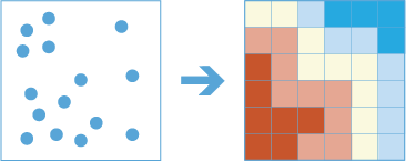
Illustration
Usage
This tool identifies statistically significant spatial clusters of many features (hot spots) and few features (cold spots). It creates an output feature class with a z-score, p-value, and confidence level bin (
Gi_Bin) for each feature in the input..During analysis, the input points (incidents) are aggregated into bins of a specified size, and they are then analyzed to determine hot spots. The aggregated bins must contain a variety of values (counts of points in a bin should be highly variable).
The z-scores and p-values are measures of statistical significance that tell you whether to reject the null hypothesis using aggregated bins. That is, they indicate whether the observed spatial clustering of high or low values is more pronounced than one would expect in a random distribution of those values. The z-score and p-value fields do not reflect any kind of False Discovery Rate (FDR) correction.
A high z-score and small p-value for a feature indicates an intense presence of point incidents. A low negative z-score and small p-value indicates an absence of point incidents. The higher (or lower) the z-score, the more intense the clustering. A z-score near zero indicates no apparent spatial clustering.
The z-score is based on the randomization null hypothesis computation. For more information on z-scores, see What is a z-score? What is a p-value?
This tool requires that the input layer is projected or that the output coordinate system is a projected coordinate system.
When input features are analyzed using time steps, each time step is analyzed independent of features outside the time step.
The Time Step Reference parameter can be a date and time value or solely a date value; it cannot be solely a time value.
This geoprocessing tool is powered by ArcGIS GeoAnalytics Server. Analysis is completed on GeoAnalytics Server, and results are stored in your content in ArcGIS Enterprise.
When running GeoAnalytics Server tools, the analysis is completed on GeoAnalytics Server. For optimal performance, make data available to GeoAnalytics Server through feature layers hosted on your ArcGIS Enterprise portal or through big data file shares. Data that is not local to GeoAnalytics Server will be moved to GeoAnalytics Server before analysis begins. This means that it will take longer to run a tool and, in some cases, moving the data from ArcGIS Pro to GeoAnalytics Server may fail. The threshold for failure depends on your network speeds, as well as the size and complexity of the data. It is recommended that you always share your data or create a big data file share.
Learn more about sharing data to your portal
Learn more about creating a big data file share through Server Manager
Similar analysis can also be completed using the following:
The ArcGIS Pro Optimized Hot Spot Analysis geoprocessing tool in the Spatial Statistics toolbox.
The ArcGIS Pro Find Hot Spots geoprocessing tool in the Standard Feature Analysis toolbox.
Parameters
| Label | Explanation | Data type |
|---|---|---|
|
Point Layer |
The point feature class for which hot spot analysis will be performed. |
Feature Set |
|
Output Name |
The name of the output layer with the z-score and p-value results. |
String |
|
Bin Size |
The distance interval that represents the bin size and units into which the Point Layer parameter value will be aggregated. The distance interval must be a linear unit. |
Linear Unit |
|
Neighborhood Size |
The spatial extent of the analysis neighborhood. This value determines which features are analyzed together to assess local clustering. |
Linear Unit |
|
Time Step Interval (Optional) |
The interval that will be used for the time step. This parameter is only used if time is enabled for the Point Layer parameter value. |
Time Unit |
|
Time Step Alignment (Optional) |
Specifies how time steps will be aligned. This parameter is only available if the input points are time enabled and represent an instant in time.
|
String |
|
Time Step Reference (Optional) |
The time that will be used to align the time steps and time intervals. This parameter is only used if time is enabled for the Point Layer parameter value |
Date |
|
Data Store (Optional) |
Specifies the ArcGIS Data Store where the output will be stored. All results stored in a spatiotemporal big data store will be stored in WGS84. Results stored in a relational data store will maintain their coordinate system.
|
String |
Derived output
| Label | Explanation | Data type |
|---|---|---|
|
Output Feature Class |
The statistically significant hot spots. |
Feature Set |
Environments
Output Coordinate System, Extent, Current Workspace
Special cases
- Output Coordinate System
-
The coordinate system that will be used for analysis. Analysis will be completed in the input coordinate system unless specified by this parameter. For GeoAnalytics Tools, final results will be stored in the spatiotemporal data store in WGS84.
Licensing information
- Basic: Requires ArcGIS GeoAnalytics Server
- Standard: Requires ArcGIS GeoAnalytics Server
- Advanced: Requires ArcGIS GeoAnalytics Server