Computes various synthetic aperture radar (SAR) indices for SAR data, such as Radar Vegetation Index (RVI), Radar Forest Degradation Index (RFDI), and Canopy Structure Index (CSI).
The formulas used for these indices depend on the polarizations available in the input radar dataset.
Usage
The input radar data must be in linear units. If the data is in decibels (dB), use the Convert SAR Units tool to convert the radar data to linear units.
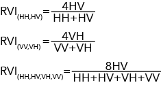
For input SAR data that is quad-polarized, the tool will provide the three possible formula options for the RVI index. RVI requires HH, HV; VV, VH; or HH, HV, VH, VV polarizations.
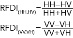
The tool will provide two possible options for the RFDI index. RFDI requires HH, HV or VV, VH polarizations.
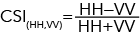
The tool will provide one option for the CSI index. CSI requires HH, VV polarizations.
For RFDI and RVI, cities, deserts, and water bodies can have values corresponding to barren, degraded, and deforested landscapes, since little or no vegetation is inherent to those regions. Although most values will fall within the 0 to 1 range, there may be outliers resulting from double bounce or volume scattering.
Radar Vegetation Index (RVI)—The Radar Vegetation Index will be used. RVI is the ratio of cross-polarized backscatter to the total backscatter from all polarizations. The values range between 0 and 1. RVI values near 0 indicate barren landscapes, while larger values indicate vegetated landscapes. This is the default.
Radar Forest Degradation Index (RFDI)—The Radar Forest Degradation Index will be used. RFDI is the normalized difference between co- and cross-polarized backscatter. Lower RFDI values (less than 0.3) indicate a denser forest. Moderate RFDI values (between 0.4 and 0.6) correspond to degraded forests. Higher RFDI values (greater than 0.6) indicate deforested landscapes.
Canopy Structure Index (CSI)—The Canopy Structure Index will be used. CSI is the normalized difference of co-polarized backscatter (HH, VV). The values range between -1 and +1 in which canopies dominated with vertical structures will have CSI values near -1, while those dominated with horizontal structures will have CSI values near 1. This option is only supported when the input radar data contains HH and VV bands.
String
Polarization Bands
(Optional)
Specifies the polarization bands that will be used in the index computation.
This parameter is only supported when the Input Radar Data parameter value is a quad-polarized SAR dataset and the Index parameter value is Radar Vegetation Index (RVI) or Radar Forest Degradation Index (RFDI).
HH, HV—The horizontal-horizontal and horizontal-vertical bands will be used in the index computation (dual-polarization). This is the default.
VV, VH—The vertical-vertical and vertical-horizontal bands will be used in the index computation (dual-polarization).
HH, HV, VH, VV—The horizontal-horizontal, horizontal-vertical, vertical-horizontal, and vertical-vertical bands will be used in the index computation (quad-polarization).
RVI—The Radar Vegetation Index will be used. RVI is the ratio of cross-polarized backscatter to the total backscatter from all polarizations. The values range between 0 and 1. RVI values near 0 indicate barren landscapes, while larger values indicate vegetated landscapes. This is the default.
RFDI—The Radar Forest Degradation Index will be used. RFDI is the normalized difference between co- and cross-polarized backscatter. Lower RFDI values (less than 0.3) indicate a denser forest. Moderate RFDI values (between 0.4 and 0.6) correspond to degraded forests. Higher RFDI values (greater than 0.6) indicate deforested landscapes.
CSI—The Canopy Structure Index will be used. CSI is the normalized difference of co-polarized backscatter (HH, VV). The values range between -1 and +1 in which canopies dominated with vertical structures will have CSI values near -1, while those dominated with horizontal structures will have CSI values near 1. This option is only supported when the input radar data contains HH and VV bands.
String
polarization_bands
(Optional)
Specifies the polarization bands that will be used in the index computation.
This parameter is only supported when the in_radar_data parameter value is a quad-polarized SAR dataset and the index parameter value is RVI or RFDI.
HH_HV—The horizontal-horizontal and horizontal-vertical bands will be used in the index computation (dual-polarization). This is the default.
VV_VH—The vertical-vertical and vertical-horizontal bands will be used in the index computation (dual-polarization).
HH_HV_VH_VV—The horizontal-horizontal, horizontal-vertical, vertical-horizontal, and vertical-vertical bands will be used in the index computation (quad-polarization).
String
Code sample
ComputeSARIndices example 1 (Python window)
This example computes RVI from a quad-polarized SAR dataset.