Watershed As Polygon (Spatial Analyst Tools)
Summary
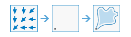
Determines the contributing polygons for a specific set of outlet locations.
Illustration
Usage
The value of each watershed will be taken from the value of the source in the Input Raster or Feature Pour Points (
in_pour_pointsin Python) parameter value. When the input pour point data is a raster, the cell values will be used.When the input pour point data is a point dataset, their values will come from a specified field. By default, the first available valid field will be used. If no valid field exists, the ObjectID field (for example,
OIDorFID) will be the default.Optionally, use the Pour Point Field (
pour_point_fieldin Python) parameter value to specify a numeric field.For the Input Flow Direction Raster (
in_flow_direction_rasterin Python) parameter value, this tool only supports the D8-type. This can be created using the Geodesic Flow Direction, Flow Direction, or Derive Continuous Flow tools, as long as they are run with the D8 flow direction type selected.Better results will be obtained if the Snap Pour Point tool is used first to help locate the pour points to cells of high accumulated flow.
The output feature class supports big integer OIDs (64-bit integer), provided that the specified output table format supports it. If the output format does not support the big integer field data type, the output frequency value will be returned as -9999. The big integer field data type is supported in file geodatabase and enterprise geodatabase tables.
This tool supports parallel processing. If your computer has multiple processors or processors with multiple cores, better performance may be achieved, particularly on larger datasets. See the Parallel processing with Spatial Analyst help topic for details on this capability and how to configure it.
When using parallel processing, temporary data will be written to manage the data chunks being processed. The default temp folder location will be on your local C drive. You can control the location of this folder by setting up a system environment variable named
TempFoldersand specifying the path to a folder to use (for example,E:\RasterCache). If you have admin privileges on your machine, you can also use a registry key (for example, [HKEY_CURRENT_USER\SOFTWARE\ESRI\ArcGISPro\Raster]).By default, this tool will use 50 percent of the available cores. If the input data is smaller than 5,000 by 5,000 cells in size, fewer cores may be used. You can control the number of cores the tool uses with the Parallel Processing Factor environment.
See Analysis environments and Spatial Analyst for additional details about the geoprocessing environments that apply to this tool.
Parameters
| Label | Explanation | Data type |
|---|---|---|
|
Input Flow Direction Raster |
The input integer raster that shows the direction of flow out of each cell. The flow direction raster can be created using the Flow Direction or the Geodesic Flow Direction tool, run using the default flow direction type D8. |
Raster Layer |
|
Input Raster or Feature Pour Points |
The input pour point locations. For a raster, this represents cells above which the contributing area, or catchment, will be determined. All cells that are not NoData will be used as source cells. For a point feature dataset, this represents locations above which the contributing area, or catchment, will be determined. |
Raster Layer; Feature Layer |
|
Output Watershed Polygons |
The output polygon feature class that delineates the contributing area. |
Feature Class |
|
Pour Point Field (Optional) |
The field that will be used to assign values to the pour point locations. If the pour point dataset is a raster, the If the pour point dataset is a feature, the first numeric field will be used. If the field contains floating-point values, they will be truncated into integers. |
Field |
|
Simplify (Optional) |
Specifies whether watershed polygon boundaries will be simplified using a topology-preserving generalization method.
|
Boolean |
|
Nest watersheds (Optional) |
Specifies whether nested polygons will be computed. Nested polygons may overlap to represent the full upstream catchment for each outlet.
|
Boolean |
Environments
Current Workspace, Extent, Geographic Transformations, Mask, Output Coordinate System, Parallel Processing Factor, Scratch Workspace, Snap Raster
Licensing information
- Basic: Requires Spatial Analyst
- Standard: Requires Spatial Analyst
- Advanced: Requires Spatial Analyst