closeViews
汇总
ArcGISProject 对象用于访问 ArcGIS Pro 工程方法和属性。 大多数地图自动化工作流都需要引用此对象。
讨论
ArcGISProject 对象通常是最先引用的对象之一(这些引用是在地图自动化脚本中创建的),因为它是用于访问 ArcGIS Pro 中大多数其他对象的主要入口点。 可使用 ArcGISProject 函数引用工程。 其属性可用于获取或设置以下工程设置: defaultGeodatabase 、 defaultToolbox 、 documentVersion 、 filePath 和其他。 其方法(例如 updateFolderConnections 、 updateDatabases 、 createMap 和 createLayout )可用于管理工程项目,用户也可以使用 copyItem 或 deleteItem 方法相应地复制或删除某些工程项目。
updateConnectionProperties 方法可用于替换工程中的数据源。 可以在 ArcGISProject 、 Map 、 Layer 或 Table 对象上替换数据源。 有关更多详细信息和代码示例,请参阅 更新和修复数据源 。
importDocument 方法允许您将地图文档 (.mxd)、globe 文档 (.3dd) 和 scene 文档 (.sxd) 导入到工程中。 此操作提供了用于将这些文档类型自动转换为 ArcGIS Pro 工程的机制。 importDocument 方法还允许您将地图文件 (.mapx)、布局文件 (.pagx) 和报表文件 (.rptx) 导入到现有工程中。
具有对 ArcGISProject 对象的引用后,您可以使用多个列表函数访问其他对象。 例如,您可以使用 listMaps 方法访问 Map 对象,或分别使用 listLayouts 和 listReports 方法访问 Layout 和 Report 对象。
下图沿左侧演示了使用列表函数导航和引用工程中对象的方法。 该图仅为示例,不显示完整对象集合和列表方法。
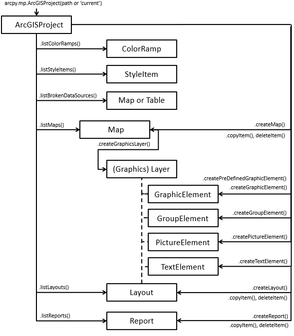
上方右侧示意图还演示了许多创建函数。 例如,您可以使用 createMap 创建 Map 对象、使用 createLayout 创建 Layout 对象或使用 createReport 创建 Report 对象。
注:
createGraphicElement 、 createGroupElement 、 createPictureElement 和 createTextElement 方法也可用于 ArcGISProject 对象,因为通过这些方法可以在 Layout 对象中创建元素,或在 Map 对象中创建图形图层。
提示:
在地图中的图形图层中创建元素时,图形图层的要素数量和整体大小均受到限制。 有关详细信息,请参阅 使用图形图层 。
有几个方法和属性仅适用于在应用程序内部运行的脚本,例如在 Python 窗口或笔记本中运行的脚本或与脚本工具关联的脚本。 它们是 activeMap 和 activeView 属性以及 closeViews() 方法。 activeMap 属性将返回与活动布局视图上的活动地图视图或活动地图框关联的 Map 对象。 如果不满足上述条件,则将返回 NoneType 。 如果地图视图为活动状态, activeView 属性将返回 MapView 对象,如果布局视图处于活动状态,则会返回 Layout 对象。 如果没有活动视图,则两种属性都将返回 None 。 当脚本在应用程序外部运行时,这些属性将始终返回 None ,因为视图仅在应用程序打开时才会相关。 从 activeView 属性返回的 MapView 对象是更改与地图视图相关联的范围的唯一方法。 MapView 类提供多个可用于更改范围的函数,例如 camera 、 panToExtent 、 ZoomToAllLayers 和 ZoomToBookmarks 。 closeViews 函数可用于关闭应用程序内的特定视图类型。 要关注特定视图,请关闭所有视图并在 Layout 、 Map 或 Report 类上使用 openView 方法。
注:
工程可以被多次引用,但是仅第一次引用可以直接保存,因为其他引用将以只读模式打开。 ArcGISProject 对象具有一个 isReadOnly 属性,该属性可用于在调用方法(例如 saveACopy 方法,而非 save )之前确定工程的读取状态。
语法
closeViews()
属性
| 名称 | 说明 | 数据类型 |
|---|---|---|
|
activeMap (只读) |
返回与应用程序内部焦点视图相关联的 注:该属性设计为在应用程序内通过脚本工具、Python 窗口或笔记本运行。 如果脚本在应用程序外部运行,则将返回 |
Map |
|
activeView (只读) |
将返回 注:该属性设计为在应用程序内通过脚本工具、Python 窗口或笔记本运行。 如果脚本在应用程序外部运行,则将返回 |
Object |
|
databases (只读) |
返回 Python 字典列表,每个字典表示工程中各个数据库的属性。 要修改数据库,请参阅 |
List |
|
dateSaved (只读) |
返回报告上次工程保存日期的 Python |
DateTime |
|
defaultGeodatabase (读取和写入) |
工程的默认地理数据库位置。 字符串必须包含地理数据库的完整路径和文件名。 注:此属性可由系统管理员通过 应用程序设置 进行锁定。 |
String |
|
defaultToolbox (读取和写入) |
工程的默认工具箱位置。 字符串必须包含工具箱的完整路径和文件名。 注:此属性可由系统管理员通过 应用程序设置 进行锁定。 |
String |
|
documentVersion (只读) |
根据上次保存文档的时间返回工程文档版本。 运行 |
String |
|
filePath (只读) |
返回报告完全限定的工程路径和文件名的字符串值。 |
String |
|
folderConnections (只读) |
返回 Python 字典列表,每个字典表示工程中各个文件夹连接的属性。 要修改文件夹连接,请参阅 |
List |
|
homeFolder (读取和写入) |
工程的主目录文件夹位置。 字符串必须包含所需位置的完整路径。 注:此属性可由系统管理员通过 应用程序设置 进行锁定。 |
String |
|
isReadOnly (只读) |
如果工程已在应用程序的另一个实例中打开或由另一个脚本参考,返回 True 。 已知当前状态可确定您是否可以 |
Boolean |
|
metadata (读取和写入) |
获取或设置工程的 |
Metadata |
|
styles (只读) |
返回工程中存在的样式列表。 列表中的值表示字符串,这些字符串可以是系统样式关键字(例如 注:收藏夹样式不会从 |
List |
|
toolboxes (只读) |
返回 Python 字典列表,每个字典表示工程中各个工具箱的属性。 要修改工具箱,请参阅 |
List |
方法
closeViews({view_type})
用于关闭当前在 ArcGIS Pro 中打开的视图窗格。
| 名称 | 说明 | 数据类型 |
|---|---|---|
|
view_type (可选) |
A constant that determines the type of views to be closed in the application.
(默认值为 MAPS_AND_LAYOUTS) |
String |
copyItem(project_item, {new_name})
创建现有 layout 、 map 或 report 工程项目的副本。
| 名称 | 说明 | 数据类型 |
|---|---|---|
|
project_item |
An object reference that represents a supported project item to be copied. |
Object |
|
new_name (可选) |
An optional string that represents the name of the new project item. If a name is not provided, the default |
String |
返回值
| 数据类型 | 说明 |
|---|---|
|
Object |
createGraphicElement(container, geometry, {style_item}, {name}, {lock_aspect_ratio})
createGraphicElement 方法用于在指定 container 中创建 GraphicElement 。
| 名称 | 说明 | 数据类型 |
|---|---|---|
|
container |
A reference to a |
Object |
|
geometry |
The appropriate |
Object |
|
style_item (可选) |
An optional reference to a |
String |
|
name (可选) |
An optional string that represents the name of the new |
String |
|
lock_aspect_ratio (可选) |
An optional (默认值为 True) |
Boolean |
返回值
| 数据类型 | 说明 |
|---|---|
|
GraphicElement |
如果提供了变量,则其将引用新返回的 |
createGroupElement(container, element_list[element_list,...], {name})
createGroupElement 方法用于在指定 container 中创建 GroupElement 。
| 名称 | 说明 | 数据类型 |
|---|---|---|
|
container |
A reference to a |
Object |
|
element_list[element_list,...] |
A list of elements that will be placed in the newly created group. 注:You can not create an empty group element, there must be existing elements to place in the group. |
List |
|
name (可选) |
An optional string that represents the name of the new |
String |
返回值
| 数据类型 | 说明 |
|---|---|
|
GroupElement |
如果提供了变量,则其将引用新返回的 |
createLayout(page_width, page_height, page_units, {name})
createLayout 方法将创建 Layout ,其将自动添加至 目录 窗格。
| 名称 | 说明 | 数据类型 |
|---|---|---|
|
page_width |
A double that specifies the width of a layout and is based on the |
Double |
|
page_height |
A double that specifies the height of a layout and is based on the |
Double |
|
page_units |
One of the following page units must be provided to describe the
|
String |
|
name (可选) |
A string that represents the name of the new layout. If a name is not provided, the default |
String |
返回值
| 数据类型 | 说明 |
|---|---|
|
Layout |
如果选择提供了变量引用,则其将表示对新 |
createMap({name}, {map_type})
此方法会创建一个地图,以自动添加至 目录 窗格。
| 名称 | 说明 | 数据类型 |
|---|---|---|
|
name (可选) |
A string that represents the name of the new map. If a name is not provided, the default |
String |
|
map_type (可选) |
The type of map to be created and are defined by the keywords below.
(默认值为 Map) |
String |
返回值
| 数据类型 | 说明 |
|---|---|
|
Map |
如果指定了变量参考,将表示受支持的 |
createPictureElement(container, geometry, path, {name}, {lock_aspect_ratio})
createPictureElement 方法用于在指定 container 中创建 PictureElement 。
| 名称 | 说明 | 数据类型 |
|---|---|---|
|
container |
A reference to a |
Object |
|
geometry |
The appropriate |
Object |
|
path |
A string that represents the full path and file name of the location of the picture. |
String |
|
name (可选) |
An optional string that represents the name of the new |
String |
|
lock_aspect_ratio (可选) |
A Boolean that controls how the picture is inserted into the envelope. If set to False, the image will be stretched to fill the entire area of the envelope. (默认值为 True) |
Boolean |
返回值
| 数据类型 | 说明 |
|---|---|
|
PictureElement |
如果提供了变量,则其将引用新返回的 |
createPredefinedGraphicElement(container, geometry, shape_type, {style_item}, {name}, {lock_aspect_ratio})
createPredefinedGraphicElement 方法用于在指定 container 中创建 GraphicElement 。
| 名称 | 说明 | 数据类型 |
|---|---|---|
|
container |
A reference to a |
Object |
|
geometry |
The appropriate |
Object |
|
shape_type |
A string constant that represents the predefined shape that will be created. The following is a list of valid values:
|
String |
|
style_item (可选) |
An optional reference to a |
String |
|
name (可选) |
An optional string that represents the name of the new |
String |
|
lock_aspect_ratio (可选) |
An optional (默认值为 True) |
Boolean |
返回值
| 数据类型 | 说明 |
|---|---|
|
GraphicElement |
如果提供了变量,则其将引用新返回的 |
createReport(page_info, data_source, {fields[fields,...]}, {statistics[statistics,...]}, {name}, {template}, {styling})
createReport 方法生成的报表会自动添加到 目录 窗格中。
| 名称 | 说明 | 数据类型 |
|---|---|---|
|
page_info |
A dictionary that specifies the page width, height, units, and margins for the new report. The page width and height are based on the
The page margins restrict editable space for the report. An 8.5 inch by 11 inch report, for example, with The margin key values are defined as follows:
|
Dictionary |
|
data_source |
A |
Object |
|
fields[fields,...] (可选) |
A list of field dictionaries that include the following keys:
The
|
Dictionary |
|
statistics[statistics,...] (可选) |
A list of statistic dictionaries that include field name and statistic type. If a value is specified, the
The acceptable
|
Dictionary |
|
name (可选) |
A string that represents the name of the new report. If no name is provided, the default |
String |
|
template (可选) |
A string that represents a default template for the new report. The acceptable values are defined as follows:
(默认值为 ATTR_LIST) |
String |
|
styling (可选) |
A string that represents a default styling for the new report. The acceptable values are defined as follows:
(默认值为 BLACK_AND_WHITE) |
String |
返回值
| 数据类型 | 说明 |
|---|---|
|
Report |
如果提供了变量引用,则其将表示对新 |
createTextElement(container, geometry, text_type, text, {text_size}, {font_family_name}, {font_style_name}, {style_item}, {name}, {lock_aspect_ratio})
createTextElement 方法用于在指定 container 中创建 TextElement 对象。
| 名称 | 说明 | 数据类型 |
|---|---|---|
|
container |
A |
Object |
|
geometry |
The appropriate |
Object |
|
text_type |
Specifies the type of text that will be created. The following is a list of valid values:
|
String |
|
text |
The text string associated with the element. |
String |
|
text_size (可选) |
The size of the text in points. |
Double |
|
font_family_name (可选) |
The text symbol font associated with the element. 注:The value that appears in the Font name drop-down list on the ribbon does not always match the |
String |
|
font_style_name (可选) |
The font style name. Depending on the font, the style may include regular, bold, italic, any combination of these, or an extended list. 注:The value that appears in the Font style drop-down list on the ribbon does not always match the |
String |
|
style_item (可选) |
A |
String |
|
name (可选) |
The new |
String |
|
lock_aspect_ratio (可选) |
Specifies whether the element can be resized. For example, if the value is (默认值为 False) |
Boolean |
返回值
| 数据类型 | 说明 |
|---|---|
|
TextElement |
如果提供了变量,则其将引用新返回的 |
deleteItem(project_item)
| 名称 | 说明 | 数据类型 |
|---|---|---|
|
project_item |
An object that represents a supported project item to be deleted. |
Object |
importDocument(document_path, {include_layout}, {reuse_existing_maps}, {log_files})
将地图文档 (.mxd)、globe 文档 (.3dd) 和场景文档 (.sxd) 导入到 ArcGIS Pro 工程中。 还可以用于导入地图文件 (.mapx)、布局文件 (.pagx) 和报表文件 (.rptx) 的内容。
| 名称 | 说明 | 数据类型 |
|---|---|---|
|
document_path |
A string that includes the system path and name of a document ( |
String |
|
include_layout (可选) |
A Boolean parameter indicating whether the layout from a map document ( (默认值为 True) |
Boolean |
|
reuse_existing_maps (可选) |
A Boolean parameter to prevent the creation of duplicate maps in the project. If (默认值为 False) |
Boolean |
|
log_files (可选) |
A Boolean parameter that controls if log files are written to the (默认值为 True) |
Boolean |
返回值
| 数据类型 | 说明 |
|---|---|
|
Object |
返回的对象类型基于正在导入的文件。 导入地图文档 ( |
listBasemaps({wildcard})
listBasemaps 方法将引用工程中的可用底图。
| 名称 | 说明 | 数据类型 |
|---|---|---|
|
wildcard (可选) |
A wildcard is based on the label as it appears in the basemap gallery in the application and is not case sensitive. A combination of asterisks (*) and characters can be used to help limit the resulting list. (默认值为 None) |
String |
返回值
| 数据类型 | 说明 |
|---|---|
|
List |
返回 String 对象的 Python 列表。 |
以下脚本用于向地图添加底图。
p = arcpy.mp.ArcGISProject('current')
bm = p.listBasemaps('National Geographic*')[0]
m = p.listMaps('Yosemite National Park')[0]
m.addBasemap(bm)
listBrokenDataSources()
返回项目中到所有地图原始源数据的连接存在断开情况的 Layer 和/或 Table 对象的 Python 列表。
返回值
| 数据类型 | 说明 |
|---|---|
|
List |
listColorRamps({wildcard})
listColorRamps 方法将引用工程中的可用色带。
| 名称 | 说明 | 数据类型 |
|---|---|---|
|
wildcard (可选) |
通配符将基于色带名称显示在应用程序中。星号 (*) 和字符的组合可用于帮助限制生成的列表。 (默认值为 None) |
String |
返回值
| 数据类型 | 说明 |
|---|---|
|
List |
将返回 ColorRamp 对象列表。 |
listLayouts({wildcard})
返回 ArcGIS 工程 (.aprx) 中的 Layout 对象的 Python 列表。
| 名称 | 说明 | 数据类型 |
|---|---|---|
|
wildcard (可选) |
通配符基于布局名称且不区分大小写。星号 (*) 和字符的组合可用于帮助限制生成的列表。 (默认值为 None) |
String |
返回值
| 数据类型 | 说明 |
|---|---|
|
List |
ArcGIS 工程中的 Layout 对象的 Python 列表。 |
listMaps({wildcard})
返回 ArcGIS 工程 (.aprx) 中的 Map 对象的 Python 列表。
| 名称 | 说明 | 数据类型 |
|---|---|---|
|
wildcard (可选) |
通配符基于地图名称且不区分大小写。星号 (*) 和字符的组合可用于帮助限制生成的列表。 (默认值为 None) |
String |
返回值
| 数据类型 | 说明 |
|---|---|
|
List |
ArcGIS 工程中的 Map 对象的 Python 列表。 |
listReports({wildcard})
返回 ArcGIS 工程 (.aprx) 中的 报表 对象的 Python 列表。
| 名称 | 说明 | 数据类型 |
|---|---|---|
|
wildcard (可选) |
通配符基于报表名称且不区分大小写。星号 (*) 和字符的组合可用于帮助限制生成的列表。 (默认值为 None) |
String |
返回值
| 数据类型 | 说明 |
|---|---|
|
List |
ArcGIS 工程中的 报表 对象的 Python 列表。 |
listStyleItems(style, {style_class}, {wildcard})
listStyleItems 方法引用工程中可用的系统、个人和自定义样式。
| 名称 | 说明 | 数据类型 |
|---|---|---|
|
style |
A string that represents either a system style name such as ArcGIS 2D, a personal style such as Favorites, or a custom 注:Styles must exist in the project before they can be referenced using (默认值为 None) |
String |
|
style_class (可选) |
A string that represents the class of the style items as they appear in the Catalog View window.
(默认值为 None) |
String |
|
wildcard (可选) |
A wildcard based on the style item name as it appears in the application. A combination of asterisks (*) and characters can be used to limit the length of the resulting list. (默认值为 None) |
String |
返回值
| 数据类型 | 说明 |
|---|---|
|
List |
返回 |
save()
将更改保存到 ArcGISProject (.aprx)。
saveACopy(file_name)
将 ArcGISProject (.aprx) 保存到新文件路径或另存为新文件名。
| 名称 | 说明 | 数据类型 |
|---|---|---|
|
file_name |
用来将 |
String |
updateConnectionProperties(current_connection_info, new_connection_info, {auto_update_joins_and_relates}, {validate}, {ignore_case})
updateConnectionProperties 方法使用工作空间字典或路径替换连接属性。
| 名称 | 说明 | 数据类型 |
|---|---|---|
|
current_connection_info |
A string that represents the workspace path or a Python dictionary that contains connection properties to the source you want to update. If an empty string or |
String |
|
new_connection_info |
A string that represents the workspace path or a Python dictionary that contains connection properties with the new source information. |
String |
|
auto_update_joins_and_relates (可选) |
If set to (默认值为 True) |
Boolean |
|
validate (可选) |
If set to (默认值为 True) |
Boolean |
|
ignore_case (可选) |
Determines whether searches will be case sensitive. By default, queries are case sensitive. To perform queries that are not case sensitive, set (默认值为 False) |
Boolean |
updateDatabases(databases[databases,...], {validate})
updateDatabases 方法将使用描述每个数据库的字典列表替换工程数据库。
| 名称 | 说明 | 数据类型 |
|---|---|---|
|
databases[databases,...] |
A list of Python dictionaries that each contain properties to an individual database. The dictionary keys are defined below.
|
List |
|
validate (可选) |
If set to (默认值为 True) |
Boolean |
返回值
| 数据类型 | 说明 |
|---|---|
|
List |
无效数据库的列表。 |
updateFolderConnections(folder_connections[folder_connections,...], {validate})
updateFolderConnections 方法将使用描述每个连接的字典列表替换工程文件夹连接。
| 名称 | 说明 | 数据类型 |
|---|---|---|
|
folder_connections[folder_connections,...] |
A list of Python dictionaries that each contain connection properties to an individual folder. The dictionary keys are defined below.
|
List |
|
validate (可选) |
If set to (默认值为 True) |
Boolean |
返回值
| 数据类型 | 说明 |
|---|---|
|
List |
没有有效连接的文件夹列表。 |
updateStyles(styles[styles,...])
updateStyles 方法使用字符串列表更新工程样式。
| 名称 | 说明 | 数据类型 |
|---|---|---|
|
styles[styles,...] |
A list of strings that are either a system style keyword such as |
List |
返回值
| 数据类型 | 说明 |
|---|---|
|
List |
无法添加的样式列表。 检查拼写或文件路径错误。 |
以下脚本用于将一个系统样式和一个自定义样式追加到“目录”窗格中当前显示的样式列表中。
p = arcpy.mp.ArcGISProject('current')
s = p.styles
s.append('Pushpins')
s.append(r'C:\Projects\YosemiteNP\Yosemite.stylx')
p.updateStyles(s)
updateToolboxes(toolboxes[toolboxes,...], {validate})
updateToolboxes 方法将使用字典列表替换工程工具箱。
| 名称 | 说明 | 数据类型 |
|---|---|---|
|
toolboxes[toolboxes,...] |
A list of Python dictionaries that each contain toolbox information. The dictionary keys are defined below.
|
List |
|
validate (可选) |
Specifies whether all toolboxes will be added to the project. If set to (默认值为 True) |
Boolean |
返回值
| 数据类型 | 说明 |
|---|---|
|
List |
没有有效连接的工具箱列表。 |
代码示例
下面的脚本演示了如何将文档导入到现有 ArcGIS Pro 模板工程。 同时还设置了一些默认工程设置并将结果保存到新工程文件。
import arcpy
#Reference a blank, template project on disk
p = arcpy.mp.ArcGISProject(r"C:\Projects\blank.aprx")

#Import documents set up default GDB and toolbox
p.importDocument(r"C:\Projects\YosemiteNP\Documents\Yosemite.mxd")
p.importDocument(r"C:\Projects\YosemiteNP\Documents\Yosemite_3DViews.3dd")

#Set up default GDB and toolbox
p.defaultGeodatabase = r"C:\Projects\YosemiteNP\Data_Vector\YosemiteData.gdb"
p.defaultToolbox = r"C:\Projects\YosemiteNP\Analysis\AnalysisTools.tbx"

#Save out to a new, different project
p.saveACopy(r"C:\Projects\YosemiteNP\Yosemite.aprx")
以下脚本用于打印工程中对象的名称。 脚本使用关键字 CURRENT ,因此应从 Python 窗口中运行。 脚本将打印每个地图的名称,后跟其图层列表。 然后,将打印各个布局的名称以及页面大小信息。
p = arcpy.mp.ArcGISProject('CURRENT')

#Project information
print(f'Project: {p.filePath}')
print(f' Version: {p.documentVersion}')
print(f' Last saved: {p.dateSaved}')

#Loop through each map
print('Maps and Layers:')
for m in p.listMaps():
    print(' Map: ' + m.name)
    for lyr in m.listLayers():
        print('  Layer: ' + lyr.name)

#Loop through each layout
print('Layouts:')
for lyt in p.listLayouts():
    print(f' Name: {lyt.name}')
    print(f'  W/H: {lyt.pageWidth} x {lyt.pageHeight}')
    print(f'  Units: {lyt.pageUnits}')
下面的脚本使用了关键字 CURRENT ,因此应从 Python 窗口运行此脚本。 该脚本将复制现有地图、向其添加新图层、设置控制新打开的视图范围的地图默认相机属性、将地图视图导出为 PDF 并从工程中移除新创建的地图。
p = arcpy.mp.ArcGISProject('CURRENT')

#Create a copy of an existing map
existingMap = p.listMaps('Yosemite National Park')[0]
rangerMap = p.copyItem(existingMap, new_name='Ranger Stations')

#Add ranger stations layer file
lyrx = arcpy.mp.LayerFile(r'C:\Projects\YosemiteNP\LayerFiles\Ranger Stations.lyrx')
rangerMap.addLayer(lyrx)

#Close any current layout or map views
p.closeViews('MAPS_AND_LAYOUTS')

#Set the default map camera to the extent of the park boundary before opening the new view
#default camera only affects newly opened views
lyr = rangerMap.listLayers('*Park Boundary')[1]
rangerMap.defaultCamera.setExtent(arcpy.Describe(lyr).extent)
rangerMap.openView()

#export the newly opened active view to PDF, then delete the new map
mv = p.activeView
mv.exportToPDF(r'C:\Temp\RangerStations.pdf', width=700, height=500, resolution=96)

#Optionally delete the temporary map when the export is complete
p.deleteItem(rangerMap)
以下脚本可遍历工程中的所有文件地理数据库图层,并将各个唯一的工作空间路径添加到 文件夹 工程项目文件夹。
import arcpy, os
p = arcpy.mp.ArcGISProject(r'C:\Projects\YosemiteNP\Yosemite.aprx')

#Check project read-state before continuing
if p.isReadOnly:
  print('WARNING: project is already opened. Exiting.')
  exit

folderList = [p.homeFolder]
for m in p.listMaps():
  for l in m.listLayers():
    if not l.isWebLayer:
      if not l.isBasemapLayer:
        if l.supports('DATASOURCE'):
          dirPath = os.path.dirname(l.dataSource)
          #Parce out GDB folders
          pathParts = dirPath.split(os.sep)
          for part in pathParts:
            if part.endswith(".gdb"):
              gdbName = part
              dirPath = dirPath.split("\\"+gdbName, 1)[0]
          #Add unique path to list
          if dirPath not in folderList:
            folderList.append(dirPath)
folderList.sort()
for f in folderList:
    print(f)
print(f'Total Unique Folders: {len(folderList)}')

#Add each folder connection from FolderList, there MUST be one default folder.

fcList = []
for folder in folderList:
  if folder == r'C:\Projects\YosemiteNP':
    defName2 = r'Default Folder'
    fcDict = {'connectionString':folder, 'alias':defName2, 'isHomeFolder':True}

  else:
    fcDict = {'connectionString':folder, 'alias':'', 'isHomeFolder':False}

  fcList.append(fcDict)

bfc = p.updateFolderConnections(fcList, validate=False)
print(f'Broken folder connections: {len(bfc)}')

p.saveACopy(r'C:\Projects\YosemiteNP\Yosemite_Output.aprx')
以下脚本可将新的文件地理数据库添加到 数据库 工程项目文件夹,提供工程中数据的快速访问方式。
import arcpy, os
path = r'C:\Projects\YosemiteNP'

p = arcpy.mp.ArcGISProject(os.path.join(path, 'Yosemite.aprx'))
#Check project read-state before continuing
if p.isReadOnly:
  print('WARNING: project is already opened. Exiting.')
  exit

db = p.databases

#Append new fGDBs in addition to the already existing default database
db.append({'databasePath' : os.path.join(path, r'Data_Geology\Geology.gdb'),
           'isDefaultDatabase': False})
db.append({'databasePath' : os.path.join(path, r'Data_Elev\Elevation.gdb'),
           'isDefaultDatabase': False})
db.append({'databasePath': os.path.join(path, r'\Data_LandCover\LandCover.gdb'),
           'isDefaultDatabase': False})

p.updateDatabases(db, True)
p.saveACopy(os.path.join(path, 'Yosemite_newGDBs.aprx'))
以下脚本可在工程中创建一个布局,并使用引用的系统样式创建预定义的图形元素。 将使用一个函数为添加到布局的每个矩形图形创建包络矩形。
def MakeRec_LL(llx, lly, w, h):
    xyRecList = [[llx, lly], [llx, lly+h], [llx+w,lly+h], [llx+w,lly], [llx,lly]]
    xyRecList = [[1,1],[1, 2], [2.75, 2], [2.75, 1], [1, 1]]
    array = arcpy.Array([arcpy.Point(*coords) for coords in xyRecList])
    rec = arcpy.Polygon(array)
    return rec

p = arcpy.mp.ArcGISProject('CURRENT')
lyt = p.createLayout(6, 3, 'INCH', 'New Layout with Rectangles')

#Construct a pre-defined rectangle graphic element using a system style item
# and a rectangle function that takes x/y min/max and a width/height
# using the lower left corner as a start location

polyStyle = p.listStyleItems('ArcGIS 2D', 'Polygon', 'Orchard')[0]

p.createPredefinedGraphicElement(lyt, MakeRec_LL(1, 1, 1.75, 1), 'RECTANGLE',
                                 polyStyle, 'ArcPy_Rectangle_Env',
                                 lock_aspect_ratio=False)

#Construct the same element above using a point location
rec = p.createPredefinedGraphicElement(lyt, arcpy.Point(3, 1), 'RECTANGLE',
                                       polyStyle, 'ArcPy_Rectangle_Pt',
                                       lock_aspect_ratio=False)
rec.elementWidth = 1.75
rec.elementHeight = 1

lyt.openView()
以下脚本可创建包含图形图层的地图。 接下来,可将两个图片添加到图形图层中的新图层组中。 将使用一个函数为每个图片创建包络矩形,并且它们将偏移 3000000 个地图单位。
def MakeRec_UL(ulx, uly, w, h):
    xyRecList = [[ulx, uly], [ulx+w, uly], [ulx+w,uly-h], [ulx,uly-h], [ulx,uly]]
    array = arcpy.Array([arcpy.Point(*coords) for coords in xyRecList])
    rec = arcpy.Polygon(array)
    return rec

p = arcpy.mp.ArcGISProject('current')
m = p.createMap('New Map', 'Map') #WGS 1984 Web Mercator (auxiliary sphere)
gl = m.createGraphicsLayer('New Graphics Layer')

###Replace with pictures of YOUR favorite pets!
picPath1 = r'C:\Projects\Fenway.jpg'
picPath2 = r'C:\Projects\Chowdah.png'

x = -13000000; y = 5000000; w = 1000000; h = 1500000

pic1 = p.createPictureElement(gl, MakeRec_UL(x, y, w, h), picPath1, 'Fenway')
pic2 = p.createPictureElement(gl, MakeRec_UL(x+3000000, y, w, h), picPath2, 'Chowdah')
m.openView()

newGroup = p.createGroupElement(gl, [pic1, pic2], 'Favorite Pets')
以下脚本创建一个包含地图图层分组的报表。
p = arcpy.mp.ArcGISProject('current')

#Find the report data source
m = p.listMaps('New York')[0]
ds = m.listLayers('Bus Stops')[0]

#Set page info
pi = {'width': 8.5, 'height': 11, 'units': 'INCH', 'margins': 'NORMAL'}

#Define the fields
f = [{'fieldName' : 'Borough', 'sortOrder' : 'ASC', 'groupField' : True},
        {'fieldName' : 'StopID', 'sortOrder' :  'ASC', 'groupField' : False},
        {'fieldName' : 'NumofLines', 'sortOder' : 'None', 'groupField' : False},
        {'fieldName' : 'Capacity', 'sortOrder' : 'None', 'groupField' : False}]

#Define the statistics
s = [{'fieldName' : 'NumofLines', 'statistic' : 'MEAN'},
        {'fieldName' : 'Capacity', 'statistic' : 'MAX'}]

#Create report
r = p.createReport(
    page_info = pi,
    data_source = ds,
    fields = f,
    statistics = s,
    name = 'createReport Example')

#Open new report view
r.openView()