Create routes
 Available with the Linear Referencing license.
Use the Create Route tool to create a route in an LRS Network using centerline features that define the location and geometry of a route.
You can digitize centerline features from aerial photography or basemaps, copy them from other feature classes, or import them from CAD files or other ArcGIS-supported data sources.
Before using this tool to edit a feature service, you must share branch versioned LRS data as a web layer. If the feature service is not yet published, see Share as web layers. If you are using a file geodatabase LRS dataset, this tool provides limited functionality.
If you have a line network, a line is created with the new route.
Route creation follows gap calibration rules.
Beta:
You can use the ArcGIS Pro Assistant (Beta) to perform route creation and to guide you through the workflow.
Create a route
To create a route, complete the following steps:
Start ArcGIS Pro and add the centerline and LRS Network feature classes to a map.
You can also open a map in which the centerline and LRS Network layers are present.
Note:
In the LRS data model, only one centerline feature is expected at any given location. Ensure that the centerlines used for your edit do not overlap other centerlines in the LRS.
Branch versioned LRS Networks, including any network configured with a user-generated route ID, must be edited through a feature service.
Zoom to the location where you want to create a route.
The centerline features for the route must exist before creating the route.
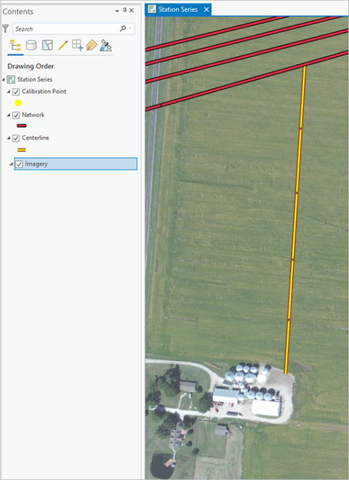
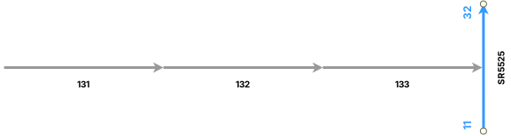
On the Linear Referencing tab, in the Route Editing group, click Create
 .
The Create Route pane appears with the Select By Rectangle tool
 as the default.
Select one or more centerlines at the location of the new route.
Tip:
You can also click the Select one or more centerlines drop-down arrow and choose a different selection tool, or use the interactive selection tools on the Map tab.
You can keep the centerlines selected after creating the route by checking the Keep centerlines chosen and selected box in the Linear Referencing options.
The Keep centerlines chosen and selected option in the Linear Referencing options is useful if you are creating a route in the engineering network and want to create another one for the continuous network using the same centerlines, or vice versa.
The selected centerlines are highlighted on the map, and the Allow choosing of one or more centerlines button
 appears in the Create Route pane.
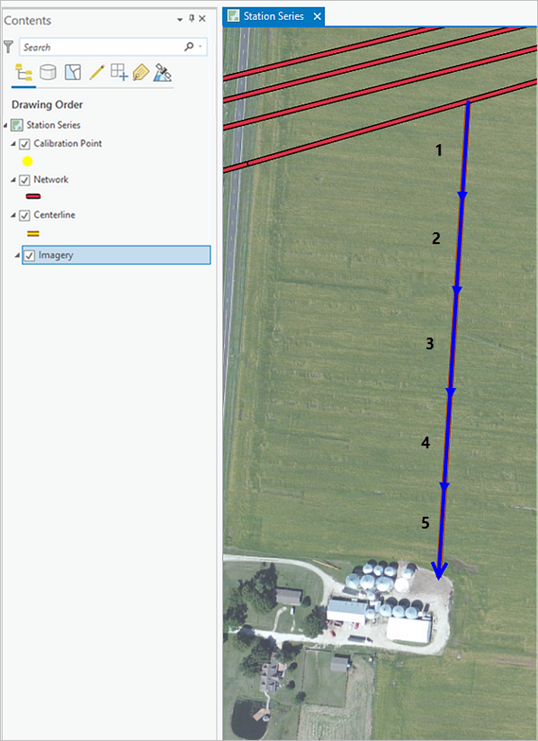
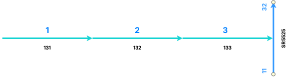
In the Create Route pane, click Allow choosing of one or more centerlines
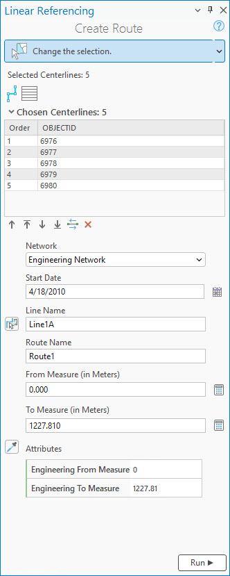
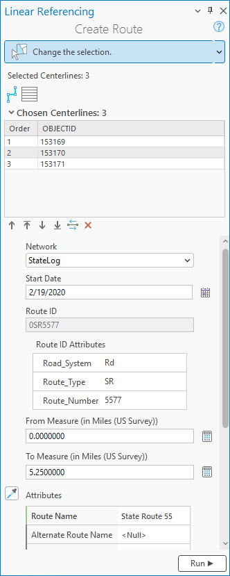
.The Chosen Centerlines section appears in the pane with the centerlines listed in order of selection. On the map, the selected centerlines are numbered and highlighted.
Note:
The direction of digitization determines the direction of calibration, increasing in the direction of digitization. You can reverse direction for the selected centerlines using the Flip the direction of the centerlines button
 . The flip occurs in memory only and is not permanent.
If the centerline contains curves, they are converted into a densified polyline feature.
Optionally, select one or more rows from the Order column and use the tools below the table to change the centerline selection order.
Tip:
You can also drag a row to change the order.
To change the display field in the Chosen Centerlines section, right-click the centerline feature class in the Contents pane, and choose Properties from the context menu. On the Layer Properties dialog box, click the Display tab, and click the Display field drop-down arrow to change its value. In the example above, the display field is
OBJECTID.
The following table describes the tools available in the Chosen Centerlines section:
Tool Tool name Tool description Allow choosing of one or more centerlines Allows you to choose the centerlines on the map and displays them in a table by order of selection. Use the move buttons below the table or drag rows to reorder the chosen centerlines. 
Clear the currently chosen centerlines Clears the chosen centerlines and keeps the selected centerlines. You can reselect after clicking this button or click the Allow choosing of one or more centerlines button a second time.
Move chosen centerlines up Moves one or more selected centerlines up a row in the table order. 
Move chosen centerlines to the top Moves one or more centerlines to the top of the table order. 
Move chosen centerlines down Moves one or more centerlines down a row in the table order. 
Move chosen centerlines to the bottom Moves one or more centerlines to the bottom of the table order. Flip the direction of the centerlines Reverses the direction of the chosen centerlines. The flip occurs in memory only and is not permanent. 
Remove the chosen centerlines Removes the chosen centerline from the table order but leaves it selected. The map reflects changes in the centerline selection order.
Click the Network drop-down arrow and choose the LRS Network to which you want to add a route.
Click the Calendar
 next to the Start Date text box and choose a start date for the route.
You can also double-click the Start Date text box to insert the current date or enter a date in the box.
To create a route on a line network, do one of the following:
To create the route on a new line, provide a line name in the Line Name text box. The line name must be unique within the selected network.
To create the route on an existing line, provide an existing line name or use the Choose line from map button
 to select an existing line from the map.
Provide a route name in the Route Name text box.
For each time slice, the route name must be unique within the selected network.
Provide a route ID in the Route ID text box.
For each time slice, the route ID must be unique within the selected network.
If your LRS Network is configured with a multifield route ID, use the Route ID Attributes section to configure the route ID. The image in step 5 shows an example of the Route ID Attributes section.
Provide a start measure in the From Measure text box.
The default start measure is 0.000.
Note:
For an engineering (line) network, you can provide measures as station values in the 00+00.00 or 00+00.000 format.
Optionally, recalculate the start measure by doing the following:
Provide a value in the To Measure text box.
Click Recalculate From Measure
 next to the From Measure text box.
Optionally, update the end measure in the To Measure text box.
The default end measure is calculated using the geometric length of the selected centerline.
Note:
Z-values are considered when calculating the geometric length of the centerlines.
Optionally, recalculate the end measure by doing the following:
Update the From Measure value if necessary.
Click Recalculate To Measure
next to the To Measure text box.
Provide values for the additional fields in the Attributes section as necessary.
The fields in the Attributes section support coded value and range domains.
Tip:
To copy attributes from an existing route, click Copy attribute values by choosing route from map
 and choose an existing route.
Click Run.
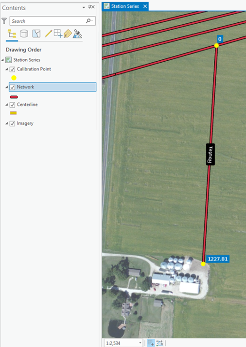
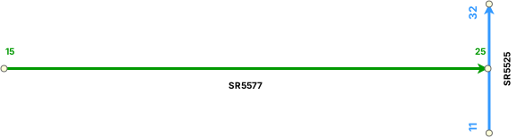
The route is created.
Note:
If the route edit introduces one or more physical gaps on the route, a prompt appears before the tool runs. If you don't plan to create a gapped route, click No.
If the route already has one or more physical gaps and the edit does not introduce more, no prompt appears.
You can disable this warning by unchecking the Warn before allowing route edits that can create physical gaps check box in the Linear Referencing options.
After creating a route, you can use the Identify Routes  tool on the Linear Referencing tab to click a route and view its information. You can also hover over a route to display route and measure information on the map. You can set map scale options for the display of route and measure information in the Linear Referencing options. When hovering near a feature, you can turn snapping on to improve the accuracy of the pointer.
Complex route creation scenarios
The following sections describe examples of complex route creation, including loop, lollipop, branch, alpha, barbell, and infinity routes.
Loop route
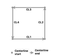
In the following example, four centerlines (CL1, CL2, CL3, and CL4) are used to create a loop route:
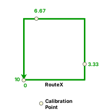
Calibration points are added at the start of the loop (0), end of the loop (10), and at a third (3.33) and two-thirds of the loop (6.67).
Lollipop route
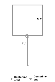
In the following example, two centerlines (CL1, CL2) are used to create a lollipop route:
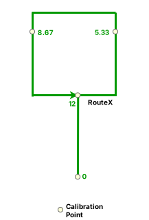
RouteX is created with calibration points at the start of the stick portion (0), the end of the loop portion (12), and at a third (5.33) and two-thirds of the loop portion (8.67).
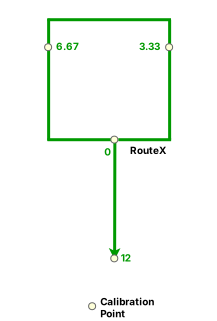
In the second example, two centerlines (CL1, CL2) with different directions compared to the example above are used to create a lollipop route.
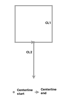
RouteX is created with calibration points at the start of the loop portion (0), at a third (3.33) and two-thirds of the loop portion (6.67), and in the stick portion (12) at the end of the lollipop.
Branch route
In the following example, two centerlines (CL1, CL2) are used to create a branch route:
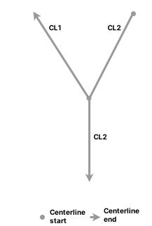
RouteX is created with calibration points at the start of the branch, the end of the branch, and at the start and end of an imaginary branch edge.
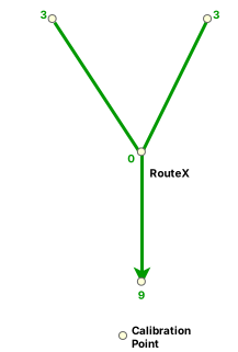
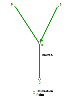
In the second example, two centerlines (CL1, CL2) are used to create a branch route.
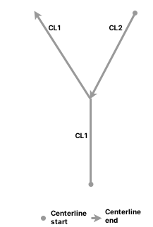
RouteX is created with calibration points at the start of the branch, the end of the branch, and at the start and end of an imaginary branch edge.
Alpha route
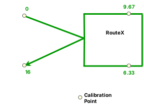
In the following example, three centerlines (CL1, CL2, CL3) are used to create an alpha route:
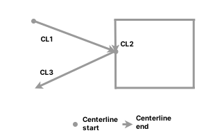
RouteX is created with calibration points at the start (0) and end (16) of the alpha portion, and at a third (6.33) and two-thirds (9.67) of the loop portion.
Barbell route
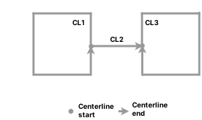
In the following example, three centerlines (CL1, CL2, CL3) are used to create a barbell route:
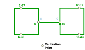
RouteX is created with calibration points at the start (0) and end (18) of the barbell, and at a third (2.67 and 12.67) and two-thirds (5.33 and 15.33) of each loop portion.
Infinity route that starts and ends at an intersection
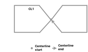
In the following example, one centerline (CL1) is used to create an infinity loop route that starts and ends at an intersection:
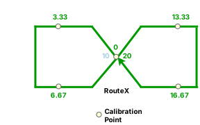
RouteX is created with calibration points at the start (0) and end (20) of the infinity route, and at a third (3.33 and 13.33) and two-thirds (6.67 and 16.67) of each loop portion.
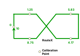
In the following example, one centerline (CL1) is used to create an infinity loop that starts and ends on a loop:
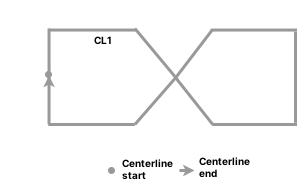
RouteX is created with calibration points at the start (0) and end (10) of the infinity route, and at the middle (1.25 and 8.75) of every path in the primary loop, and at a third (4.17) and two-thirds (5.83) of the secondary loop.
Route creation in a utility network dataset
In a combined LRS and utility network dataset, the centerline features in the centerline (Pipeline Line) feature class involved in route creation can have prepopulated start and end measures.
Note:
If the measures are not provided using the centerline feature class, the LRS route editing tools provide start and end measures on the route.
When you use multiple centerlines, the coincident points of the centerline features must have the same measures. The tool populates the start and end measures of the route using these measure values.
Coincident points of the centerlines match
In the following example, the end measure of CL1 (14) matches the start measure of CL2 (14):

In this case, you can create a route because the coincident points of the centerlines match. The following diagram shows Route X created from CL1 and CL2, with calibration points at the ends of each centerline:

Coincident points of the centerlines do not match
In the following example, the end measure of CL1 (16) does not match the start measure of CL2 (14):

In this case, you cannot create a route because the coincident points of the centerlines do not match.
Coincident points match with identical start and end measures
In the following example, the coincident points of the centerlines match, but the start measure and end measure of CL2 are the same (19):

In this case, you cannot create a route because it would be nonmonotonic.
Route creation in a line network
The following examples show route creation in a line network.
New route at the beginning of a line
In this example, there are two existing routes on a line: R1 and R2. A new route, R3, is created by selecting CL1 at the beginning of the existing routes on the line. Consequently, the line order is updated for the existing downstream routes R1 and R2.
The following table and diagram show the centerline and route before route creation:
| Route ID | From Measure | To Measure | Line Order |
|---|---|---|---|
| R1 | 14 | 20 | 100 |
| R2 | 24 | 30 | 200 |

The following table and diagram show the centerline and route after route creation:
| Route ID | From Measure | To Measure | Line Order |
|---|---|---|---|
| R3 | 1 | 10 | 100 |
| R1 | 14 | 20 | 200 |
| R2 | 24 | 30 | 300 |

New route in the middle of a line
In this example, there are two existing routes on a line: R1 and R2. A new route, R3, is created by selecting CL2 in the middle of the existing routes on the line. Consequently, the line order of the existing downstream route, R2, is updated, while the line order of the upstream route, R1, remains the same.
The following table and diagram show the centerline and route before route creation:
| Route ID | From Measure | To Measure | Line Order |
|---|---|---|---|
| R1 | 1 | 10 | 100 |
| R2 | 24 | 30 | 200 |

The following table and diagram show the centerline and route after route creation:
| Route ID | From Measure | To Measure | Line Order |
|---|---|---|---|
| R1 | 1 | 10 | 100 |
| R3 | 14 | 20 | 200 |
| R2 | 24 | 30 | 300 |

New route in a route gap
In this example, there are two existing routes on a line: R2, and a gapped route, R1. CL2 is located inside the R1 gap. A new route, R3, is created by selecting CL2 in the middle of the existing routes on the line. Consequently, the line order of the existing downstream route R2 is updated to 300. The line order of the upstream route, R1, remains the same.
The following table and diagram show the centerline and route before route creation:
| Route ID | From Measure | To Measure | Line Order |
|---|---|---|---|
| R1 | 1 | 15 | 100 |
| R2 | 17 | 20 | 200 |

The following table and diagram show the centerline and route after route creation:
| Route ID | From Measure | To Measure | Line Order |
|---|---|---|---|
| R1 | 1 | 15 | 100 |
| R3 | 14 | 20 | 200 |
| R2 | 17 | 20 | 300 |
