Extract Water (Image Analyst Tools)
Summary
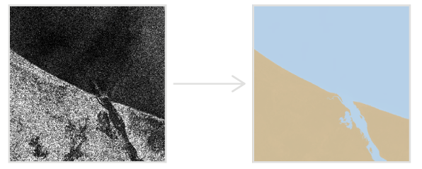
Finds water bodies using input synthetic aperture radar (SAR) data and a digital elevation model (DEM).
The tool uses the input radar backscatter to determine whether pixels should be classified as water; then creates polygons for water areas. The tool will also create polygons for areas that are not water, which will be considered land areas.
Illustration
Usage
Calibrate the input radar data to gamma nought using the Apply Radiometric Calibration tool. This optimizes delineation and classification, especially in large radar scenes.
The input radar data may not align with the output feature class. If the input radar data is not orthorectified, the tool transforms the Output Feature Class parameter value using the DEM Raster parameter. When no DEM is provided, the tool performs a transformation using an ellipsoidal surface. For optimal transformation of the Output Feature Class parameter value, provide an input DEM for the DEM Raster parameter. The input DEM must be in the WGS84 (EPSG:4326) geographic coordinate system.
This tool can also be used to create water polygons or land polygons for input into other SAR tools, such as Detect Bright Ocean Objects and Detect Dark Ocean Areas.
Parameters
| Label | Explanation | Data type |
|---|---|---|
|
Input Radar Data |
The input radar data. |
Raster Dataset; Raster Layer |
|
Output Feature Class |
The output polygon feature class that depicts water and land polygons. |
Feature Class |
|
Minimum Area (Optional) |
The minimum area to extract as a water body. The default value is 50,000 square meters. |
Areal Unit |
|
DEM Raster (Optional) |
The input DEM. If the input radar data is not orthorectified, this DEM will be used to orthorectify the output result. This DEM will also be used to optimize the polygon construction. |
Mosaic Layer; Raster Layer |
|
Apply geoid correction (Optional) |
Specifies whether the vertical reference system of the input DEM will be transformed to ellipsoidal height. Most elevation datasets are referenced to sea level orthometric height, so a correction is required in these cases to convert to ellipsoidal height.
|
Boolean |
Environments
Compression, Current Workspace, NoData, Output CONFIG Keyword, Parallel Processing Factor, Pyramid, Raster Statistics, Resampling Method, Scratch Workspace, Snap Raster, Tile Size
Licensing information
- Basic: Requires Image Analyst
- Standard: Requires Image Analyst
- Advanced: Requires Image Analyst