LAS の建物分類 (3D Analyst ツール)
サマリー
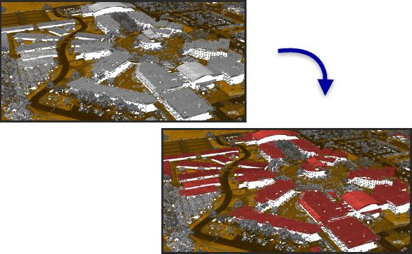
LAS 形式の点群データ内にある建物を分類します。
図
使用法
クラス コード値が 0、1 と 6 のポイントは、建物の屋上の特性と適合しているかどうかを判定するために評価されます。 既存の建物に分類されたポイントは、検出条件を満たしていない場合、既存の建物に分類されたポイントを再利用するオプションが指定されていない限り、クラス コード値 1 に再割り当てされます。
This tool was designed with an emphasis on aerial lidar, which usually captures building rooftops. Points representing walls, vertical facades, and small rooftop features—屋根窓や煙突などは、建物の分類に含まれない場合があります。 そのようなポイントが必要な場合は、屋根の上下にあるポイントを分類するオプションを含むツールの実行を検討してください。
このツールを実行する前に地表ポイントを分類します。 地表ポイントが分類されていない場合は、LAS の地表分類 ツールを使用します。 地表ポイントが分類されたがそれらのクラス コード値が 2 以外の場合は、LAS クラス コードの変更 ツールを使用してクラス コード値を適切に再割り当てします。
方法 パラメーターは、写真測量データ パラメーターがオンの場合は使用されません。
保留またはオーバーラップのフラグが設定されたポイントは無視されます。 保留ポイントは、元々分類に使用しないよう定義されています。 オーバーラップ ポイントを含めると、点密度が大きく変動することがあり、飛行経路間でノイズ関連のキャリブレーションの問題が発生する可能性があるため、これらのポイントは無視されます。
パラメーター
| ラベル | 説明 | データ タイプ |
|---|---|---|
|
入力 LAS データセット |
分類される LAS データセット。 |
LAS Dataset Layer |
|
屋上の高さの最小値 (オプション) |
屋上ポイントに識別される最低ポイントを定義する、地表からの高さ。 |
Linear Unit |
|
最小面積 |
建物の屋上の最小エリア。 |
Areal Unit |
|
統計の計算 (オプション) |
LAS データセットで参照されている
|
Boolean |
|
処理範囲 (オプション) |
評価されるデータの範囲。
座標を手動で入力する場合、アクティブなマップの座標系の座標を数値で指定する必要があります。 マップで、入力した座標と異なる表示単位が使用されることがあります。 南と西の座標にはマイナス値の記号を使用します。 |
Extent |
|
処理境界 |
処理対象のエリアを定義するポリゴン フィーチャ (複数可)。 |
Feature Layer |
|
範囲と重なる LAS ファイル全体を処理 (オプション) |
処理範囲の適用方法を指定します。
|
Boolean |
|
平均ポイント間隔 |
LAS ポイントの平均間隔。 このパラメーターは使用されなくなりました。 |
Linear Unit |
|
既存の建物に分類されたポイントの再利用 (オプション) |
既存の建物に分類されたポイントを再利用するか再評価するかを指定します。
|
Boolean |
|
写真測量データ (オプション) |
|
Boolean |
|
分類方法 (オプション) |
使用される分類方法を指定します。
|
String |
|
屋上より上のポイントの分類 (オプション) |
検出した屋上の平面より上のポイントを分類するかどうかを指定します。
|
Boolean |
|
屋上より上の最大高度 (オプション) |
建物の屋上より上にあるポイントの最大高度。屋上より上のクラス コード パラメーター値を使用して分類されます。 |
Linear Unit |
|
屋上より上のクラス コード (オプション) |
屋上より上にあるポイントに割り当てられるクラス コード。 |
Long |
|
屋上より下のポイントの分類 (オプション) |
屋上と地表の間にあるポイントを分類するかどうかを指定します。
|
Boolean |
|
屋上より下のクラス コード (オプション) |
屋上と地表の間にあるポイントに割り当てられるクラス コード。 |
Long |
|
ピラミッドの更新 (オプション) |
クラス コードが変更された後、LAS データセットのピラミッドを更新するかどうかを指定します。
|
Boolean |
 - 範囲は、アクティブなマップまたはシーンに基づきます。
 - 範囲は、マップまたはシーンに描画された四角形に基づきます。
 - 範囲は、アクティブなマップ レイヤーに基づきます。 使用可能なレイヤーを選択するか、[すべてのレイヤーのデータの範囲] オプションを使用します。 各マップ レイヤーには、次のオプションがあります。
 - レイヤーのすべてのフィーチャの範囲。
 - 選択したフィーチャの範囲を使用します。
 - レイヤーの表示フィーチャの範囲。
 - 範囲は、既存のデータセットに基づきます。
 - 範囲は、すべての入力データの共通範囲になります。
 - 範囲は、すべての入力データの結合された範囲になります。
 - 範囲をクリップボードにコピーしたり、クリップボードから貼り付けたりできます。
 - 範囲の座標と座標系をクリップボードにコピーします。
 - 範囲はデフォルト値にリセットされます。
派生した出力
| ラベル | 説明 | データ タイプ |
|---|---|---|
|
派生 LAS データセット |
建物の屋上に分類される LAS データセット。 |
LAS Dataset Layer |
環境
ライセンス情報
- Basic: 3D Analyst が必要
- Standard: 3D Analyst が必要
- Advanced: 3D Analyst が必要