closeViews
Краткая информация
Объект ArcGISProject обеспечивает доступ к методам и свойствам проекта ArcGIS Pro. Ссылка на этот объект существенна для большинства автоматизированных рабочих процессов для карты.
Обсуждение
Объект ArcGISProject обычно является одним из первых объектов, на которые дается ссылка в скрипте автоматизации карты, потому что он является основной точкой входа для доступа к большинству других объектов в ArcGIS Pro. Ссылки на проект даются с помощью функции ArcGISProject. Ее свойства позволяют получать или задавать параметры проекта, такие как defaultGeodatabase, defaultToolbox, documentVersion, filePath и др. Ее методы позволяют управлять такими элементами проекта, как updateFolderConnections, updateDatabases, createMap и createLayout, а также копировать или удалять некоторые элементы проекта, используя методы copyItem или deleteItem, соответственно.
Метод updateConnectionProperties удобен для замены источников данных в проекте. Источники данных могут быть заменены в объектах ArcGISProject, Map, Layer или Table. Более подробную информацию и примеры кода см. в разделе справки Обновление и исправление источников данных.
Метод importDocument позволяет вам импортировать документы карты (.mxd), глобуса (.3dd) и сцены (.sxd) в проект. Это обеспечивает механизм для автоматизации преобразования этих типов документов в проект ArcGIS Pro. Метод importDocument также позволяет импортировать файлы карт (.mapx), файлы компоновок (.pagx) и файлы отчетов (.rptx) в имеющийся проект.
Получив ссылку на объект ArcGISProject, вы можете перейти к другим объектам, используя различные функции списка. Например, вы можете получить доступ к объекту Map с помощью метода listMaps или к объекту Layout и к объекту Report с помощью методов listLayouts и listReports, соответственно.
На следующей диаграмме, в левой части, показано использование функций списков для навигации и ссылок на объекты в проекте. Диаграмма является лишь примером и не отображает полный набор объектов и методов списков.
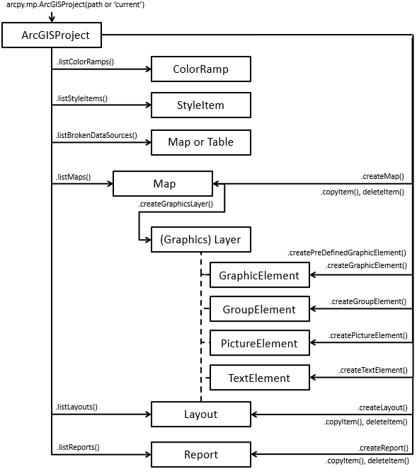
На диаграмме выше, в правой части, показано использование многих функций создания объектов. Например, вы можете использовать createMap для создания объекта Map, createLayout для создания Layout или createReport для создания объекта Report.
Примечание:
Методы createGraphicElement, createGroupElement, createPictureElement и createTextElement также доступны в объекте ArcGISProject, поскольку они позволяют создавать элементы либо в объекте Layout, либо графический слой в объекте Map.
Подсказка:
При создании элементов в графическом слое на карте, графические слои ограничены заданным количеством объектов и общим размером. Дополнительные сведения см. в разделе Работа с графическими слоями.
Есть несколько методов и свойств, работающих только со скриптами, которые запускаются внутри приложения, например со скриптами, выполняемыми в окне Python, в блокноте или со скриптами, связанными с инструментами-скриптами. Это и свойства activeMap и activeView, и сам метод closeViews(). Свойство activeMap возвращает объект Map, связанный либо с активным видом карты или с активным фреймом карты в активном виде компоновки. Если эти условия не соблюдаются, будет возвращен NoneType. Свойство activeView возвращает объект MapView, если активен вид карты, или объект Layout, если активен вид компоновки. Если не активен ни один из видов, оба свойства вернут значение None. Эти свойства всегда возвращают None, если скрипт запущен за пределами приложения, так как виды релевантны только в случае, когда приложение открыто. Объект MapView, возвращаемый свойством activeView, является единственным методом изменения экстента, связанного с видом карты. В классе MapView доступно множество функций, позволяющих вам изменить экстент, такие как camera, panToExtent, ZoomToAllLayers и ZoomToBookmarks. Функция closeViews полезна для закрытия определенных типов видов в приложении. Чтобы сосредоточить внимание на определенном виде, закройте все виды и используйте метод openView в классе Layout, Map или Report.
Примечание:
На проекты можно ссылаться несколько раз, но только первая ссылка может быть сохранена напрямую, поскольку остальные ссылки будут открыты только для чтения. У объекта ArcGISProject есть свойство isReadOnly, которое можно использовать для определения состояния чтения проекта перед вызовом метода, такого как saveACopy вместо save.
Синтаксис
closeViews()
Свойства
| Имя | Объяснение | Тип данных |
|---|---|---|
|
activeMap (Только для чтения) |
Возвращает объект Примечание:Это свойство предназначено для выполнения из приложения с помощью инструмента-скрипта, окна Python или блокнота. Если скрипт выполняется вне приложения, будет возвращено значение |
Map |
|
activeView (Только для чтения) |
Возвращает Примечание:Это свойство предназначено для выполнения из приложения с помощью инструмента-скрипта, окна Python или блокнота. Если скрипт выполняется вне приложения, будет возвращено значение |
Object |
|
databases (Только для чтения) |
Возвращает список словарей Python, каждый из которых представляет свойства для отдельных баз данных в проекте. Для изменения баз данных изучите метод |
List |
|
dateSaved (Только для чтения) |
Возвращает объект Python |
DateTime |
|
defaultGeodatabase (Чтение / Запись) |
Местоположение базы геоданных проекта по умолчанию. Строка должна включать полный путь и имя файла базы геоданных. Примечание:Это свойство может быть заблокировано системными администраторами через Настройки приложения. |
String |
|
defaultToolbox (Чтение / Запись) |
Местоположение набора инструментов проекта по умолчанию. Строка должна включать полный путь и имя файла набора инструментов. Примечание:Это свойство может быть заблокировано системными администраторами через Настройки приложения. |
String |
|
documentVersion (Только для чтения) |
Возвращает версию документа проекта на основе времени последнего сохранения. Выполнение |
String |
|
filePath (Только для чтения) |
Возвращает строковое значение, содержащее полное имя и путь к проекту. |
String |
|
folderConnections (Только для чтения) |
Возвращает список словарей Python, каждый из которых представляет свойства для отдельных подключений к папкам в проекте. Чтобы изменить подключения к папкам, изучите метод |
List |
|
homeFolder (Чтение / Запись) |
Местоположение домашней папки проекта. Строка должна включать полный путь к требуемому местоположению. Примечание:Это свойство может быть заблокировано системными администраторами через Настройки приложения. |
String |
|
isReadOnly (Только для чтения) |
Возвращает True, если проект уже был открыт в другом экземпляре приложения или на него ссылался другой скрипт. Знание текущего состояния позволяет вам определить, можете ли вы |
Boolean |
|
metadata (Чтение / Запись) |
Получение или установка класса информации |
Metadata |
|
styles (Только для чтения) |
Возвращает список стилей, присутствующих в проекте. Значения в списке представляют собой строки, которые являются либо ключевым словом системного стиля, таким как Примечание:Стиль Избранное не возвращается из свойства |
List |
|
toolboxes (Только для чтения) |
Возвращает список словарей Python, каждый из которых представляет свойства для отдельных наборов инструментов в проекте. Для изменения наборов инструментов см. метод |
List |
Методы
closeViews({view_type})
Закройте панели видов, открытых в данный момент в ArcGIS Pro.
| Имя | Объяснение | Тип данных |
|---|---|---|
|
view_type (Дополнительный) |
A constant that determines the type of views to be closed in the application.
(Значение по умолчанию — MAPS_AND_LAYOUTS) |
String |
copyItem(project_item, {new_name})
Создает копию существующего элемента проекта layout, map или report.
| Имя | Объяснение | Тип данных |
|---|---|---|
|
project_item |
An object reference that represents a supported project item to be copied. |
Object |
|
new_name (Дополнительный) |
An optional string that represents the name of the new project item. If a name is not provided, the default |
String |
Возвращаемое значение
| Тип данных | Объяснение |
|---|---|
|
Object |
Если указана ссылка на переменную, возвращаемый объект будет содержать элемент проекта layout, map или report. |
createGraphicElement(container, geometry, {style_item}, {name}, {lock_aspect_ratio})
Метод createGraphicElement, который создает GraphicElement в определенном container.
| Имя | Объяснение | Тип данных |
|---|---|---|
|
container |
A reference to a |
Object |
|
geometry |
The appropriate |
Object |
|
style_item (Дополнительный) |
An optional reference to a |
String |
|
name (Дополнительный) |
An optional string that represents the name of the new |
String |
|
lock_aspect_ratio (Дополнительный) |
An optional (Значение по умолчанию — True) |
Boolean |
Возвращаемое значение
| Тип данных | Объяснение |
|---|---|
|
GraphicElement |
Если указана переменная, она будет ссылаться на вновь возращенный объект |
createGroupElement(container, element_list[element_list,...], {name})
Метод createGroupElement создает GroupElement в указанном container.
| Имя | Объяснение | Тип данных |
|---|---|---|
|
container |
A reference to a |
Object |
|
element_list[element_list,...] |
A list of elements that will be placed in the newly created group. Примечание:You can not create an empty group element, there must be existing elements to place in the group. |
List |
|
name (Дополнительный) |
An optional string that represents the name of the new |
String |
Возвращаемое значение
| Тип данных | Объяснение |
|---|---|
|
GroupElement |
Если указана переменная, она будет ссылаться на вновь возращенный объект |
createLayout(page_width, page_height, page_units, {name})
Метод createLayout создает Layout, которая автоматически добавляется на панель Каталог.
| Имя | Объяснение | Тип данных |
|---|---|---|
|
page_width |
A double that specifies the width of a layout and is based on the |
Double |
|
page_height |
A double that specifies the height of a layout and is based on the |
Double |
|
page_units |
One of the following page units must be provided to describe the
|
String |
|
name (Дополнительный) |
A string that represents the name of the new layout. If a name is not provided, the default |
String |
Возвращаемое значение
| Тип данных | Объяснение |
|---|---|
|
Layout |
Если дополнительно указана ссылка на переменную, она будет представлять собой ссылку на новый объект |
createMap({name}, {map_type})
Этот метод создает карту, которая автоматически добавляется на панель Каталог.
| Имя | Объяснение | Тип данных |
|---|---|---|
|
name (Дополнительный) |
A string that represents the name of the new map. If a name is not provided, the default |
String |
|
map_type (Дополнительный) |
The type of map to be created and are defined by the keywords below.
(Значение по умолчанию — Map) |
String |
Возвращаемое значение
| Тип данных | Объяснение |
|---|---|
|
Map |
Если указана ссылка на переменную, она будет представлять один из поддерживаемых объектов |
createPictureElement(container, geometry, path, {name}, {lock_aspect_ratio})
Метод createPictureElement, который создает PictureElement в определенном container.
| Имя | Объяснение | Тип данных |
|---|---|---|
|
container |
A reference to a |
Object |
|
geometry |
The appropriate |
Object |
|
path |
A string that represents the full path and file name of the location of the picture. |
String |
|
name (Дополнительный) |
An optional string that represents the name of the new |
String |
|
lock_aspect_ratio (Дополнительный) |
A Boolean that controls how the picture is inserted into the envelope. If set to False, the image will be stretched to fill the entire area of the envelope. (Значение по умолчанию — True) |
Boolean |
Возвращаемое значение
| Тип данных | Объяснение |
|---|---|
|
PictureElement |
Если указана переменная, она будет ссылаться на вновь возращенный объект |
createPredefinedGraphicElement(container, geometry, shape_type, {style_item}, {name}, {lock_aspect_ratio})
Метод createPredefinedGraphicElement, который создает GraphicElement в определенном container.
| Имя | Объяснение | Тип данных |
|---|---|---|
|
container |
A reference to a |
Object |
|
geometry |
The appropriate |
Object |
|
shape_type |
A string constant that represents the predefined shape that will be created. The following is a list of valid values:
|
String |
|
style_item (Дополнительный) |
An optional reference to a |
String |
|
name (Дополнительный) |
An optional string that represents the name of the new |
String |
|
lock_aspect_ratio (Дополнительный) |
An optional (Значение по умолчанию — True) |
Boolean |
Возвращаемое значение
| Тип данных | Объяснение |
|---|---|
|
GraphicElement |
Если указана переменная, она будет ссылаться на вновь возращенный объект |
createReport(page_info, data_source, {fields[fields,...]}, {statistics[statistics,...]}, {name}, {template}, {styling})
Метод createReport создает отчет, который автоматически добавляется на панель Каталог.
| Имя | Объяснение | Тип данных |
|---|---|---|
|
page_info |
A dictionary that specifies the page width, height, units, and margins for the new report. The page width and height are based on the
The page margins restrict editable space for the report. An 8.5 inch by 11 inch report, for example, with The margin key values are defined as follows:
|
Dictionary |
|
data_source |
A |
Object |
|
fields[fields,...] (Дополнительный) |
A list of field dictionaries that include the following keys:
The
|
Dictionary |
|
statistics[statistics,...] (Дополнительный) |
A list of statistic dictionaries that include field name and statistic type. If a value is specified, the
The acceptable
|
Dictionary |
|
name (Дополнительный) |
A string that represents the name of the new report. If no name is provided, the default |
String |
|
template (Дополнительный) |
A string that represents a default template for the new report. The acceptable values are defined as follows:
(Значение по умолчанию — ATTR_LIST) |
String |
|
styling (Дополнительный) |
A string that represents a default styling for the new report. The acceptable values are defined as follows:
(Значение по умолчанию — BLACK_AND_WHITE) |
String |
Возвращаемое значение
| Тип данных | Объяснение |
|---|---|
|
Report |
Если указана ссылка на переменную, она будет представлять собой ссылку на новый объект |
createTextElement(container, geometry, text_type, text, {text_size}, {font_family_name}, {font_style_name}, {style_item}, {name}, {lock_aspect_ratio})
Метод createTextElement, который создает объект TextElement в определенном container.
| Имя | Объяснение | Тип данных |
|---|---|---|
|
container |
A |
Object |
|
geometry |
The appropriate |
Object |
|
text_type |
Specifies the type of text that will be created. The following is a list of valid values:
|
String |
|
text |
The text string associated with the element. |
String |
|
text_size (Дополнительный) |
The size of the text in points. |
Double |
|
font_family_name (Дополнительный) |
The text symbol font associated with the element. Примечание:The value that appears in the Font name drop-down list on the ribbon does not always match the |
String |
|
font_style_name (Дополнительный) |
The font style name. Depending on the font, the style may include regular, bold, italic, any combination of these, or an extended list. Примечание:The value that appears in the Font style drop-down list on the ribbon does not always match the |
String |
|
style_item (Дополнительный) |
A |
String |
|
name (Дополнительный) |
The new |
String |
|
lock_aspect_ratio (Дополнительный) |
Specifies whether the element can be resized. For example, if the value is (Значение по умолчанию — False) |
Boolean |
Возвращаемое значение
| Тип данных | Объяснение |
|---|---|
|
TextElement |
Если указана переменная, она будет ссылаться на вновь возращенный объект |
deleteItem(project_item)
Удаляет элементы проекта: компоновка, карта или отчет.
| Имя | Объяснение | Тип данных |
|---|---|---|
|
project_item |
An object that represents a supported project item to be deleted. |
Object |
importDocument(document_path, {include_layout}, {reuse_existing_maps}, {log_files})
Импортирует документы карты (.mxd), глобуса (.3dd) и сцены (.sxd) в проект ArcGIS Pro. Также может импортировать содержание файлов карт (.mapx), файлов компоновки (.pagx) и файлов отчетов (.rptx).
| Имя | Объяснение | Тип данных |
|---|---|---|
|
document_path |
A string that includes the system path and name of a document ( |
String |
|
include_layout (Дополнительный) |
A Boolean parameter indicating whether the layout from a map document ( (Значение по умолчанию — True) |
Boolean |
|
reuse_existing_maps (Дополнительный) |
A Boolean parameter to prevent the creation of duplicate maps in the project. If (Значение по умолчанию — False) |
Boolean |
|
log_files (Дополнительный) |
A Boolean parameter that controls if log files are written to the (Значение по умолчанию — True) |
Boolean |
Возвращаемое значение
| Тип данных | Объяснение |
|---|---|
|
Object |
Тип возвращаемого объекта зависит от импортируемого файла. При импорте документа карты ( |
listBasemaps({wildcard})
Метод listBasemaps ссылается на базовые карты, доступные в проекте.
| Имя | Объяснение | Тип данных |
|---|---|---|
|
wildcard (Дополнительный) |
A wildcard is based on the label as it appears in the basemap gallery in the application and is not case sensitive. A combination of asterisks (*) and characters can be used to help limit the resulting list. (Значение по умолчанию — None) |
String |
Возвращаемое значение
| Тип данных | Объяснение |
|---|---|
|
List |
Возвращает список Python объектов String. |
Следующий скрипт добавляет на карту базовую карту.
p = arcpy.mp.ArcGISProject('current')
bm = p.listBasemaps('National Geographic*')[0]
m = p.listMaps('Yosemite National Park')[0]
m.addBasemap(bm)
listBrokenDataSources()
Возвращает список объектов Python Слой (Layer) и/или Таблица (Table), которые имеют поврежденные подключения к оригинальным исходным данным для всех карт проекта.
Возвращаемое значение
| Тип данных | Объяснение |
|---|---|
|
List |
Список объектов Python Слой (Layer) и/или Таблица (Table). |
listColorRamps({wildcard})
Метод listColorRamps ссылается на цветовые схемы, доступные в проекте.
| Имя | Объяснение | Тип данных |
|---|---|---|
|
wildcard (Дополнительный) |
Подстановочный символ основан на имени цветовой схемы, как оно выглядит в приложении. Для наложения ограничений на результирующий список можно использовать сочетание звездочек (*) и символов. (Значение по умолчанию — None) |
String |
Возвращаемое значение
| Тип данных | Объяснение |
|---|---|
|
List |
Возвращает список объектов ColorRamp. |
listLayouts({wildcard})
Возвращает список Python объектов Layout (Компоновка) в проекте ArcGIS (.aprx).
| Имя | Объяснение | Тип данных |
|---|---|---|
|
wildcard (Дополнительный) |
Групповой символ базируется на имени компоновки и не является чувствительным к регистру. Для наложения ограничений на результирующий список можно использовать сочетание звездочек (*) и символов. (Значение по умолчанию — None) |
String |
Возвращаемое значение
| Тип данных | Объяснение |
|---|---|
|
List |
Список Python объектов Layout (Компоновка) в проекте ArcGIS. |
listMaps({wildcard})
Возвращает список Python объектов Map (Карта) в проекте ArcGIS (.aprx).
| Имя | Объяснение | Тип данных |
|---|---|---|
|
wildcard (Дополнительный) |
Групповой символ базируется на имени карты и не является чувствительным к регистру. Для наложения ограничений на результирующий список можно использовать сочетание звездочек (*) и символов. (Значение по умолчанию — None) |
String |
Возвращаемое значение
| Тип данных | Объяснение |
|---|---|
|
List |
Список Python объектов Map (Карта) в проекте ArcGIS. |
listReports({wildcard})
Возвращает список Python объектов Отчет в проекте ArcGIS (.aprx).
| Имя | Объяснение | Тип данных |
|---|---|---|
|
wildcard (Дополнительный) |
Групповой символ базируется на имени отчета и не является чувствительным к регистру. Для наложения ограничений на результирующий список можно использовать сочетание звездочек (*) и символов. (Значение по умолчанию — None) |
String |
Возвращаемое значение
| Тип данных | Объяснение |
|---|---|
|
List |
Список Python объектов Отчет в проекте ArcGIS. |
listStyleItems(style, {style_class}, {wildcard})
Метод listStyleItems ссылается на системные, персональные и пользовательские стили, доступные в проекте.
| Имя | Объяснение | Тип данных |
|---|---|---|
|
style |
A string that represents either a system style name such as ArcGIS 2D, a personal style such as Favorites, or a custom Примечание:Styles must exist in the project before they can be referenced using (Значение по умолчанию — None) |
String |
|
style_class (Дополнительный) |
A string that represents the class of the style items as they appear in the Catalog View window.
(Значение по умолчанию — None) |
String |
|
wildcard (Дополнительный) |
A wildcard based on the style item name as it appears in the application. A combination of asterisks (*) and characters can be used to limit the length of the resulting list. (Значение по умолчанию — None) |
String |
Возвращаемое значение
| Тип данных | Объяснение |
|---|---|
|
List |
Возвращает список объектов |
save()
Сохраняет изменения в ArcGISProject (.aprx).
saveACopy(file_name)
Сохраняет ArcGISProject (.aprx) в новом месте или с другим именем.
| Имя | Объяснение | Тип данных |
|---|---|---|
|
file_name |
Строка используется для сохранения |
String |
updateConnectionProperties(current_connection_info, new_connection_info, {auto_update_joins_and_relates}, {validate}, {ignore_case})
Метод updateConnectionProperties заменяет свойства подключения, используя словарь либо путь к рабочей области.
| Имя | Объяснение | Тип данных |
|---|---|---|
|
current_connection_info |
A string that represents the workspace path or a Python dictionary that contains connection properties to the source you want to update. If an empty string or |
String |
|
new_connection_info |
A string that represents the workspace path or a Python dictionary that contains connection properties with the new source information. |
String |
|
auto_update_joins_and_relates (Дополнительный) |
If set to (Значение по умолчанию — True) |
Boolean |
|
validate (Дополнительный) |
If set to (Значение по умолчанию — True) |
Boolean |
|
ignore_case (Дополнительный) |
Determines whether searches will be case sensitive. By default, queries are case sensitive. To perform queries that are not case sensitive, set (Значение по умолчанию — False) |
Boolean |
updateDatabases(databases[databases,...], {validate})
Метод updateDatabases заменяет базы данных проекта, используя список словарей, описывающих каждую базу данных.
| Имя | Объяснение | Тип данных |
|---|---|---|
|
databases[databases,...] |
A list of Python dictionaries that each contain properties to an individual database. The dictionary keys are defined below.
|
List |
|
validate (Дополнительный) |
If set to (Значение по умолчанию — True) |
Boolean |
Возвращаемое значение
| Тип данных | Объяснение |
|---|---|
|
List |
Список некорректных баз. |
updateFolderConnections(folder_connections[folder_connections,...], {validate})
Метод updateFolderConnections заменяет подключения к папкам проекта, используя список словарей, описывающих каждое подключение.
| Имя | Объяснение | Тип данных |
|---|---|---|
|
folder_connections[folder_connections,...] |
A list of Python dictionaries that each contain connection properties to an individual folder. The dictionary keys are defined below.
|
List |
|
validate (Дополнительный) |
If set to (Значение по умолчанию — True) |
Boolean |
Возвращаемое значение
| Тип данных | Объяснение |
|---|---|
|
List |
Список папок, которые не имеют допустимых подключений. |
updateStyles(styles[styles,...])
Метод updateStyles обновляет стили проектов, используя список строк.
| Имя | Объяснение | Тип данных |
|---|---|---|
|
styles[styles,...] |
A list of strings that are either a system style keyword such as |
List |
Возвращаемое значение
| Тип данных | Объяснение |
|---|---|
|
List |
Список стилей, которые не удалось добавить. Проверьте, нет ли орфографических ошибок или ошибок в пути к файлам. |
Следующий скрипт добавляет системный и пользовательский стили к текущему списку стилей, который отображается на панели Каталога.
p = arcpy.mp.ArcGISProject('current')
s = p.styles
s.append('Pushpins')
s.append(r'C:\Projects\YosemiteNP\Yosemite.stylx')
p.updateStyles(s)
updateToolboxes(toolboxes[toolboxes,...], {validate})
Метод updateToolboxes заменяет наборы инструментов проекта, используя список словарей.
| Имя | Объяснение | Тип данных |
|---|---|---|
|
toolboxes[toolboxes,...] |
A list of Python dictionaries that each contain toolbox information. The dictionary keys are defined below.
|
List |
|
validate (Дополнительный) |
Specifies whether all toolboxes will be added to the project. If set to (Значение по умолчанию — True) |
Boolean |
Возвращаемое значение
| Тип данных | Объяснение |
|---|---|
|
List |
Список наборов инструментов, у которых нет допустимых подключений. |
Пример кода
В следующем скрипте показано, как импортировать документы в существующий проект шаблона ArcGIS Pro. Он также задает некоторые параметры проекта по умолчанию и сохраняет результат в новый файл проекта.
import arcpy
#Reference a blank, template project on disk
p = arcpy.mp.ArcGISProject(r"C:\Projects\blank.aprx")

#Import documents set up default GDB and toolbox
p.importDocument(r"C:\Projects\YosemiteNP\Documents\Yosemite.mxd")
p.importDocument(r"C:\Projects\YosemiteNP\Documents\Yosemite_3DViews.3dd")

#Set up default GDB and toolbox
p.defaultGeodatabase = r"C:\Projects\YosemiteNP\Data_Vector\YosemiteData.gdb"
p.defaultToolbox = r"C:\Projects\YosemiteNP\Analysis\AnalysisTools.tbx"

#Save out to a new, different project
p.saveACopy(r"C:\Projects\YosemiteNP\Yosemite.aprx")
Следующий скрипт печатает имя объектов в проекте. Он использует ключевое слово CURRENT, поэтому он должен быть запущен из окна Python. Скрипт печатает имя каждой карты со списком ее слоев. Затем он печатает название каждой компоновки вместе с информацией о размере страницы.
p = arcpy.mp.ArcGISProject('CURRENT')

#Project information
print(f'Project: {p.filePath}')
print(f' Version: {p.documentVersion}')
print(f' Last saved: {p.dateSaved}')

#Loop through each map
print('Maps and Layers:')
for m in p.listMaps():
    print(' Map: ' + m.name)
    for lyr in m.listLayers():
        print('  Layer: ' + lyr.name)

#Loop through each layout
print('Layouts:')
for lyt in p.listLayouts():
    print(f' Name: {lyt.name}')
    print(f'  W/H: {lyt.pageWidth} x {lyt.pageHeight}')
    print(f'  Units: {lyt.pageUnits}')
Следующий скрипт использует ключевое слово CURRENT, поэтому он должен быть запущен из окна Python. Скрипт копирует существующую карту, добавляет к ней новый слой, задает свойство камеры карты по умолчанию, которое управляет экстентом вновь открываемых видов, экспортирует вид карты в PDF и удаляет вновь созданную карту из проекта.
p = arcpy.mp.ArcGISProject('CURRENT')

#Create a copy of an existing map
existingMap = p.listMaps('Yosemite National Park')[0]
rangerMap = p.copyItem(existingMap, new_name='Ranger Stations')

#Add ranger stations layer file
lyrx = arcpy.mp.LayerFile(r'C:\Projects\YosemiteNP\LayerFiles\Ranger Stations.lyrx')
rangerMap.addLayer(lyrx)

#Close any current layout or map views
p.closeViews('MAPS_AND_LAYOUTS')

#Set the default map camera to the extent of the park boundary before opening the new view
#default camera only affects newly opened views
lyr = rangerMap.listLayers('*Park Boundary')[1]
rangerMap.defaultCamera.setExtent(arcpy.Describe(lyr).extent)
rangerMap.openView()

#export the newly opened active view to PDF, then delete the new map
mv = p.activeView
mv.exportToPDF(r'C:\Temp\RangerStations.pdf', width=700, height=500, resolution=96)

#Optionally delete the temporary map when the export is complete
p.deleteItem(rangerMap)
Следующий скрипт выполняет итерацию по всем слоям файловой базы геоданных в проекте и добавляет каждый уникальный путь к рабочей области в папку Folders с элементами проекта.
import arcpy, os
p = arcpy.mp.ArcGISProject(r'C:\Projects\YosemiteNP\Yosemite.aprx')

#Check project read-state before continuing
if p.isReadOnly:
  print('WARNING: project is already opened. Exiting.')
  exit

folderList = [p.homeFolder]
for m in p.listMaps():
  for l in m.listLayers():
    if not l.isWebLayer:
      if not l.isBasemapLayer:
        if l.supports('DATASOURCE'):
          dirPath = os.path.dirname(l.dataSource)
          #Parce out GDB folders
          pathParts = dirPath.split(os.sep)
          for part in pathParts:
            if part.endswith(".gdb"):
              gdbName = part
              dirPath = dirPath.split("\\"+gdbName, 1)[0]
          #Add unique path to list
          if dirPath not in folderList:
            folderList.append(dirPath)
folderList.sort()
for f in folderList:
    print(f)
print(f'Total Unique Folders: {len(folderList)}')

#Add each folder connection from FolderList, there MUST be one default folder.

fcList = []
for folder in folderList:
  if folder == r'C:\Projects\YosemiteNP':
    defName2 = r'Default Folder'
    fcDict = {'connectionString':folder, 'alias':defName2, 'isHomeFolder':True}

  else:
    fcDict = {'connectionString':folder, 'alias':'', 'isHomeFolder':False}

  fcList.append(fcDict)

bfc = p.updateFolderConnections(fcList, validate=False)
print(f'Broken folder connections: {len(bfc)}')

p.saveACopy(r'C:\Projects\YosemiteNP\Yosemite_Output.aprx')
Следующий скрипт добавляет новые файловые базы геоданных в папку элементов проекта Databases, обеспечивая быстрый доступ к данным из проекта.
import arcpy, os
path = r'C:\Projects\YosemiteNP'

p = arcpy.mp.ArcGISProject(os.path.join(path, 'Yosemite.aprx'))
#Check project read-state before continuing
if p.isReadOnly:
  print('WARNING: project is already opened. Exiting.')
  exit

db = p.databases

#Append new fGDBs in addition to the already existing default database
db.append({'databasePath' : os.path.join(path, r'Data_Geology\Geology.gdb'),
           'isDefaultDatabase': False})
db.append({'databasePath' : os.path.join(path, r'Data_Elev\Elevation.gdb'),
           'isDefaultDatabase': False})
db.append({'databasePath': os.path.join(path, r'\Data_LandCover\LandCover.gdb'),
           'isDefaultDatabase': False})

p.updateDatabases(db, True)
p.saveACopy(os.path.join(path, 'Yosemite_newGDBs.aprx'))
Следующий скрипт создает компоновку в проекте и предопределенные графические элементы, используя базовый системный стиль. Функция используется для создания конверта для каждого графического прямоугольника, добавляемого в компоновку.
def MakeRec_LL(llx, lly, w, h):
    xyRecList = [[llx, lly], [llx, lly+h], [llx+w,lly+h], [llx+w,lly], [llx,lly]]
    xyRecList = [[1,1],[1, 2], [2.75, 2], [2.75, 1], [1, 1]]
    array = arcpy.Array([arcpy.Point(*coords) for coords in xyRecList])
    rec = arcpy.Polygon(array)
    return rec

p = arcpy.mp.ArcGISProject('CURRENT')
lyt = p.createLayout(6, 3, 'INCH', 'New Layout with Rectangles')

#Construct a pre-defined rectangle graphic element using a system style item
# and a rectangle function that takes x/y min/max and a width/height
# using the lower left corner as a start location

polyStyle = p.listStyleItems('ArcGIS 2D', 'Polygon', 'Orchard')[0]

p.createPredefinedGraphicElement(lyt, MakeRec_LL(1, 1, 1.75, 1), 'RECTANGLE',
                                 polyStyle, 'ArcPy_Rectangle_Env',
                                 lock_aspect_ratio=False)

#Construct the same element above using a point location
rec = p.createPredefinedGraphicElement(lyt, arcpy.Point(3, 1), 'RECTANGLE',
                                       polyStyle, 'ArcPy_Rectangle_Pt',
                                       lock_aspect_ratio=False)
rec.elementWidth = 1.75
rec.elementHeight = 1

lyt.openView()
Следующий скрипт создает карту с графическим слоем. Затем он добавляет два изображения к новому составному слою внутри графического слоя. Функция используется для создания конверта для каждого изображения, они смещаются на 3000000 единиц карты.
def MakeRec_UL(ulx, uly, w, h):
    xyRecList = [[ulx, uly], [ulx+w, uly], [ulx+w,uly-h], [ulx,uly-h], [ulx,uly]]
    array = arcpy.Array([arcpy.Point(*coords) for coords in xyRecList])
    rec = arcpy.Polygon(array)
    return rec

p = arcpy.mp.ArcGISProject('current')
m = p.createMap('New Map', 'Map') #WGS 1984 Web Mercator (auxiliary sphere)
gl = m.createGraphicsLayer('New Graphics Layer')

###Replace with pictures of YOUR favorite pets!
picPath1 = r'C:\Projects\Fenway.jpg'
picPath2 = r'C:\Projects\Chowdah.png'

x = -13000000; y = 5000000; w = 1000000; h = 1500000

pic1 = p.createPictureElement(gl, MakeRec_UL(x, y, w, h), picPath1, 'Fenway')
pic2 = p.createPictureElement(gl, MakeRec_UL(x+3000000, y, w, h), picPath2, 'Chowdah')
m.openView()

newGroup = p.createGroupElement(gl, [pic1, pic2], 'Favorite Pets')
Следующий скрипт создает отчет с группировкой из слоя карты.
p = arcpy.mp.ArcGISProject('current')

#Find the report data source
m = p.listMaps('New York')[0]
ds = m.listLayers('Bus Stops')[0]

#Set page info
pi = {'width': 8.5, 'height': 11, 'units': 'INCH', 'margins': 'NORMAL'}

#Define the fields
f = [{'fieldName' : 'Borough', 'sortOrder' : 'ASC', 'groupField' : True},
        {'fieldName' : 'StopID', 'sortOrder' :  'ASC', 'groupField' : False},
        {'fieldName' : 'NumofLines', 'sortOder' : 'None', 'groupField' : False},
        {'fieldName' : 'Capacity', 'sortOrder' : 'None', 'groupField' : False}]

#Define the statistics
s = [{'fieldName' : 'NumofLines', 'statistic' : 'MEAN'},
        {'fieldName' : 'Capacity', 'statistic' : 'MAX'}]

#Create report
r = p.createReport(
    page_info = pi,
    data_source = ds,
    fields = f,
    statistics = s,
    name = 'createReport Example')

#Open new report view
r.openView()