View the LRS hierarchy
 Available with the Linear Referencing license.
A linear referencing system (LRS) dataset is a controller dataset in a feature dataset that includes all feature classes that participate in the LRS.
You can review the hierarchy in an LRS dataset to decide which types of networks exist in the LRS and the events registered with each network.
Review the LRS hierarchy from the Contents pane
To review the LRS hierarchy from the Contents pane, complete the following steps:
Start ArcGIS Pro and open a project with LRS data in the map.
In the Contents pane, click a feature layer that participate in the LRS, such as calibration points, centerlines, events, intersections, networks, or redlines.
On the Linear Referencing tab, in the Tools group, click LRS Hierarchy
 .
Tip:
If LRS Hierarchy
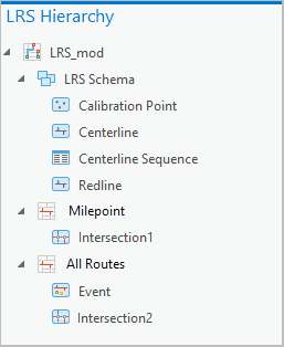
is not active, the selected feature layer is not a member of the LRS dataset. Choose a valid feature layer in the Contents pane to activate it.The LRS Hierarchy pane appears. The LRS dataset (LRS_mod in this example) is the root of the hierarchy.
The LRS Schema node
 contains the minimum schema feature classes and the centerline sequence table. The network nodes show the network, event, and intersection feature classes.
In a combined LRS and Address Data Management dataset, the Address Schema node contains the address range and site address point feature classes.

Optionally, right-click an entity in the LRS hierarchy to review its properties or add it to a new or current map.
You can access properties for the calibration point, centerline, event, intersection, network, or redline feature classes, as well as properties for the centerline sequence table.
In a combined LRS and utility network dataset, you can also access properties for the utility network feature classes.
In a combined LRS and Address Data Management dataset, you can also access properties for the site address point feature class.
Review the LRS hierarchy from the Catalog pane
The LRS dataset is included in a feature dataset in the geodatabase. When you expand the feature dataset, all members of the LRS dataset appear.
To review the LRS hierarchy from the Catalog pane, complete the following steps:
In an ArcGIS Pro project, open the Catalog pane.
In the Catalog pane, expand the geodatabase node, and expand the feature dataset.
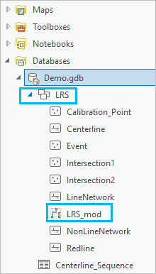
Right-click the LRS dataset, and choose LRS Hierarchy.
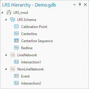
The LRS Hierarchy pane appears with the LRS dataset name (LRS_mod in this example) as the root.
Tip:
If an LRS dataset is not present in the feature dataset, the LRS hierarchy does not appear. Run the Modify LRS tool to update the LRS.
The LRS Schema node contains the minimum schema feature classes and the centerline sequence table. The network nodes show the network, event, and intersection feature classes.
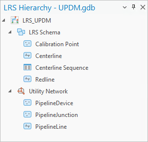
In a combined LRS and utility network dataset, the Utility Network node is available.
In a combined LRS and Address Data Management dataset, the Address Schema node contains the address range and site address point feature classes.
Optionally, right-click an entity in the LRS hierarchy to review its properties or add it to a new or current map.
You can access properties for the calibration point, centerline, event, intersection, network, or redline feature classes, as well as properties for the centerline sequence table.
In a combined LRS and utility network dataset, you can access properties for the utility network feature classes.
In a combined LRS and Address Data Management dataset, you can access properties for the site address point feature class.