Lines
 Available with the Linear Referencing license.
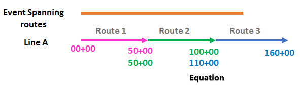
In ArcGIS Linear Referencing, a logical grouping of more than one nonbranching route is called a line. The concept of a line can be used for a continuous section of the pipeline such as a mainline pipe, lateral or discharge section, or a piggable segment such as launcher to receiver.
In ArcGIS Linear Referencing, a logical grouping of more than one nonbranching route is called a line.
While routes are a continuing, uninterrupted range of measure, a line can handle discontinuities in measure, which are known as equations.
Line information in the LRS data model
The LRS data model does not have a separate line feature class. Line information is stored with the LRS Network feature class that uses it. Lines are supported only for line networks.
Learn more about using multiple linear referencing methods
Support for lines can be configured during LRS Network creation using either the Create LRS Network or Create LRS Network From Existing geoprocessing tools.
Learn more about creating and modifying an LRS Network
The line ID is a system-generated global unique identifier (GUID) used to associate multiple routes to a single logical group called a line.
The line name is a unique user-defined name given to a line during route creation.
Each route on a line network has a line order that indicates the end-to-end sequence of routes in the line.
As route editing activities are performed, ArcGIS Linear Referencing tools regenerate the line order as needed.
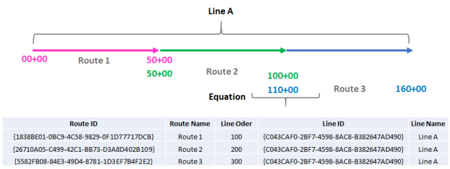
The following table provides an example of routes and their attributes on Line A in a line network:
| Route ID | Route Name | Line Order | Line ID | Line Name |
|---|---|---|---|---|
| {-7DCB) | Route1 | 100 | {-D490} | Line A |
| {-B109) | Route2 | 200 | {-D490} | Line A |
| {-F2E2) | Route3 | 300 | {-D490} | Line A |
Each route on Line A shares a line ID and line name.
Line network configuration
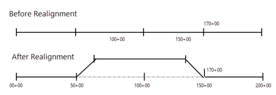
Line networks are optional. If you need to handle discontinuities in measure (equations), a line network supports this workflow. For example, when you realign (reroute) a pipeline or road, you introduce discontinuities in measure. Use these discontinuities to correlate measures between different timelines (before and after realignment). This also allows you to restrict change in measures that are downstream of the affected area.
Configuring a line network allows you to model events that span routes. Using the principle of a line network, you can track, locate, and manage the events that occur on the pipeline by their measure (engineering stations), even if the measures span routes on a line. Examples of events that span routes are DOT Class and operating pressure.
Configuring a line network allows you to model events that span routes. Using the principle of a line network, you can track, locate, and manage the events that occur on the roadway by their measure, even if the measures span routes on a line.