Use ArcGIS Pro with Microsoft OneDrive and Microsoft SharePoint
ArcGIS Pro allows you to work with projects and data that are stored on Microsoft OneDrive or Microsoft SharePoint sites. When your organization administrator has enabled protected access and you connect to Microsoft OneDrive, you participate in an environment in which access to OneDrive items by multiple users is managed to ensure data integrity.
Protected file types
The following file types are protected:
Project files (
.aprx).File geodatabases (
.gdb)Mobile geodatabases (
.geodatabase)Toolboxes (
.atbxand.tbx)Shapefiles (
.shp)Raster datasets—all supported types except cloud raster format (
.crf)Style files (
.stylx)
When protected access is enabled for each computer on which projects and data stored on OneDrive are used, ArcGIS Pro ensures that these files cannot be simultaneously edited by users on different computers.
Protected access is available only on ArcGIS Pro 3.8 and later versions. Organizations that use multiple versions of ArcGIS Pro should consider this when deciding whether to enable protected access. Projects and data stored on OneDrive or SharePoint are not protected from simultaneous access by users on earlier versions of ArcGIS Pro. This may result in data loss or file corruption.
Note:
Protected access is supported only in the Microsoft commercial cloud. It is not supported in Microsoft Graph national cloud deployments.
OneDrive and SharePoint
Microsoft OneDrive is a cloud drive service that allows you to store, access, and share files across multiple computers. You work with files on your local computer, while benefiting from cloud-based security, stability, sharing, and versioning features. OneDrive performs the following functions:
Synchronizes files between the cloud and your local disk
Automatically uploads local file changes to the cloud
Downloads changes made on other devices from the cloud to your local disk
These functions are managed by the OneDrive application—not by ArcGIS Pro. For troubleshooting, refer to the Microsoft documentation on fixing OneDrive sync problems.
Microsoft SharePoint is a cloud drive service that provides the same file storage, synchronization, and collaboration benefits as OneDrive. Files stored on SharePoint sites—including Microsoft Teams—are protected when they are stored in folders that are synced with OneDrive using OneDrive shortcuts.
Requirements for using ArcGIS Pro with OneDrive and SharePoint
The requirements for using ArcGIS Pro with OneDrive and SharePoint are as follows:
You have a OneDrive work or school account. Personal accounts are not supported.
The account is added to the OneDrive application as described in Microsoft documentation. ArcGIS Pro does not detect OneDrive accounts that are added after ArcGIS Pro starts.
Your organization administrator has enabled protected access for Microsoft OneDrive files on your computer.
You add and sign in to a OneDrive connection. If you have multiple OneDrive accounts, you can connect to each of them.
You add OneDrive shortcuts to any SharePoint folders that you want to use with ArcGIS Pro.
Access protected projects and data
When protected access is enabled, your OneDrive account is visible on the Computer tab of the Catalog pane and under the Computer node  in catalog views and browse dialog boxes. If you have multiple accounts, they are all visible.
On the Project tab of the Catalog pane, you can add connections to OneDrive folders and datasets just as you do with local or network data. There is no icon or indicator that a folder or project item is located on OneDrive; however, any item that you hover over shows its path in the item pop-up. You can also right-click an item and click Show in File Explorer  to confirm its location.
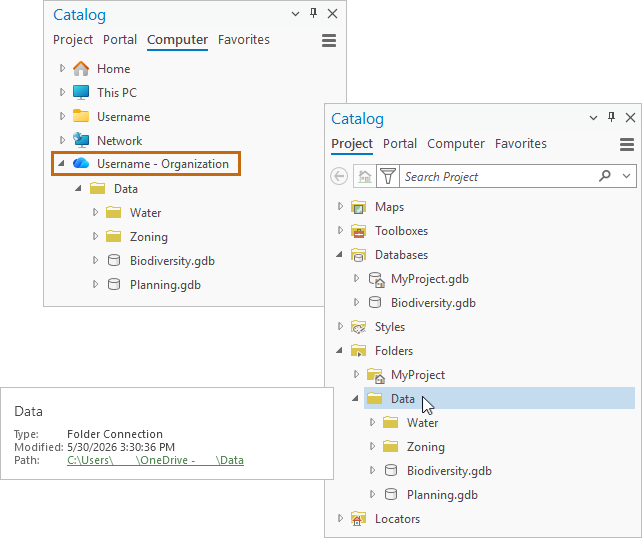
If protected access is enabled but you do not add a OneDrive connection, your access to OneDrive projects and data is read-only. If you add a OneDrive connection but do not sign in to it, you are prompted to sign in the first time that you open a OneDrive project or access a protected dataset in an ArcGIS Pro session. If you do not sign in, your access remains read-only.
Caution:
If protected access is not enabled on your computer, working with shared projects or data stored on OneDrive may result in merge conflicts and possible file corruption. To confirm that protected access is enabled, open the Authentication page in the ArcGIS Pro settings. A prominent message appears at the bottom of the page when protected access is enabled.
Work with protected projects and default items
When you open a project stored on OneDrive with protected access, it is in one of the following states:
Checked out to you. In this state:
You have exclusive write permission to the project file (
.aprx). You can make changes and save them to the project.You have exclusive write permission to the project default geodatabase and default toolbox.
Read-only. This often means that the project is currently checked out by another user; however, projects can be read-only for many reasons. ArcGIS Pro provides an informative banner message if one is available. In this state:
You cannot save changes to the project, although you can save changes to a new project.
You cannot edit or write to the project default geodatabase or toolbox.
You can check out and edit other protected datasets in the project if they are not currently checked out by another user.
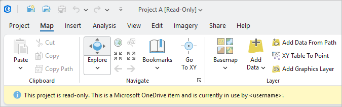
A banner message appears when you open a project that is currently checked out. The current user is identified. Read-only with unsynced edits. This means that the project was recently saved by another user (or possibly by you) with changes that are not yet synced to OneDrive. In this state:
The contents of the read-only project reflect the last synced changes.
You can work with the project like any other read-only project.
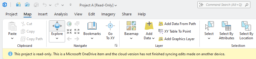
A banner message appears when you open a project that has unsynced edits. Depending on the sync progress, you may see a message that says your local file is not synced with the cloud version.
A OneDrive project is checked out to you when you open it and no other user currently has it open. It is checked in when you open a different project or exit ArcGIS Pro.
When you check out a project, other users can open it in a read-only state. When the project is checked in, the process of syncing changes to OneDrive begins. The check-in process is managed by ArcGIS Pro and happens right away. The sync process is managed by the OneDrive application. The amount of time it takes varies and cannot be known in advance.
During the sync process, users who already have the project open in a read-only state can continue to work with it; however, their view of the project is not updated with your changes—even after the sync is complete. Similarly, if a user opens a project that has unsynced changes, it opens in a read-only state that does not reflect your changes.
To see changes, a user must open (or close and reopen) the project after the sync process is complete.
Work with protected data
OneDrive datasets are protected whether they are added to a project stored on OneDrive or a project stored on a local or network drive.
If a protected dataset is the default geodatabase or default toolbox in a project, it is checked out when the project is opened and remains checked out until the project is closed. This is the case whether or not the project is stored on OneDrive. The dataset cannot be checked out by another user in the meantime, although it may be available in a read-only state.
If a protected dataset is added as a non-default item to a project, but is not currently in use in that project, it can be checked out by a user working in another project or in a read-only version of the same project. For example, a file geodatabase in an open project stored on OneDrive can be checked out by a user accessing the project in a read-only state.
When you open a project that contains a protected OneDrive dataset, the dataset is in one of the following states:
Checked out to you—In this state, you have exclusive write permission to the data, even if the project is read-only.
Read-only—This often means that the dataset is checked out by another user; however, datasets can be read-only for various reasons. In this state, you cannot edit the data or change the dataset schema even if the dataset is in a project that is checked out by you.
Unavailable—This often means that the dataset was edited by another user and the edits are not synced to OneDrive; however, datasets can be unavailable for other reasons. In this state, attempts to access the dataset result in error messages.
A protected dataset is checked out to you when you perform an action that requires ArcGIS Pro to lock the file or workspace (in the case of a file geodatabase). ArcGIS Pro checks the dataset in when it is no longer being accessed. For default project items, check-in does not occur until you open a different project or exit ArcGIS Pro. For non-default items, it also occurs when operations are performed or completed. For example, if you use a geodatabase feature class as an input to a geoprocessing tool, the geodatabase is checked out to you while the tool runs and checked in when it finishes. If you open a model view, the toolbox that contains the model is checked out to you while the view is open and checked in when the view is closed.
Note:
Occasionally, a dataset that is no longer in use may remain checked out to you. If that happens, the dataset is checked in when you close the project.
When you check out a dataset, other users can access it in a read-only state.
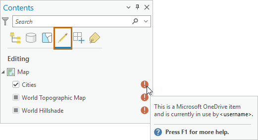
When a protected dataset is checked in—without being edited—it can be checked out by a user who is not currently working with it. It remains read-only for users who are currently working with it in a read-only state.
If you edit the dataset, it becomes unavailable to all other users when you commit the edits—before they are saved and before the dataset is checked in.
Edits include changes to the content of a dataset, such as modifying features, attributes, or metadata in a geodatabase feature class; creating or deleting feature classes in a geodatabase; or creating or deleting a model or toolset in a toolbox. Edits also include schema changes to an item, such as adding or removing fields in a table or renaming the dataset.
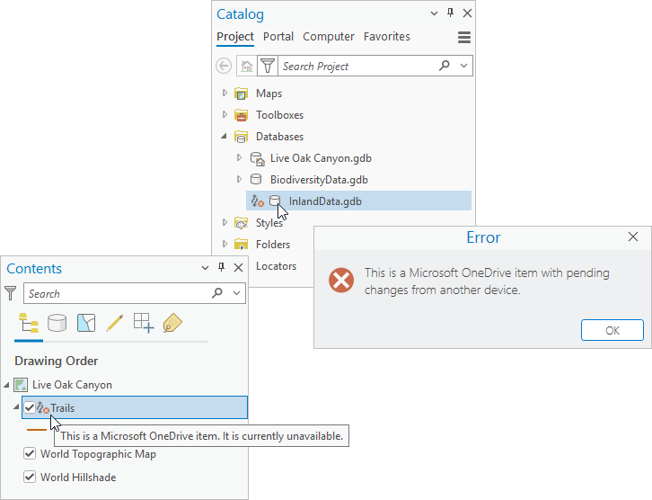
Edits to a dataset are not synced to OneDrive until you open a different project or exit ArcGIS Pro. After syncing is finished, the dataset can be checked out by any user. Users who were previously working with the data in a read-only state must refresh the dataset to clear the error state and continue working. However, a refresh does not succeed until syncing is complete. In addition, it may be necessary to remove map layers or tables that reference the dataset and add them again.
Operations that check out and check in protected datasets
The following tables describe common actions that check out and check in protected datasets.
File geodatabases, mobile geodatabases, and shapefiles
Common check out and check in actions include the following:
| Check out action | Check in action |
|---|---|
| Add a feature class or table to a map or open a map that contains a layer or table. | Remove the item from the map’s Contents pane or close the project. |
| Open a project that contains an open map with a layer or table. | Remove the item from the map’s Contents pane or close the project. |
| Run a geoprocessing tool that uses a feature class or table as input. | Completion of the operation. |
| Edit the item’s content or schema. | Close the project or exit ArcGIS Pro. |
Note:
Using any item—such as a feature class or table—in a file geodatabase or mobile geodatabase checks out the geodatabase. All items in the geodatabase become read-only for other users.
Toolboxes
Common check out and check in actions include the following:
| Check out action | Check in action |
|---|---|
| Open a geoprocessing model in a model view. | Close the model view. |
Note:
Other interactions do not check out the toolbox. For example, a toolbox is not checked out when you open a model as a geoprocessing tool, edit or run a script tool, or edit tool properties or toolbox properties.
Raster datasets
Common check out and check in actions include the following:
| Check out action | Check in action |
|---|---|
| Build pyramids. | Completion of the operation. |
| Open Pixel Editor. | Close Pixel Editor. |
| Start georeferencing. | Close georeferencing. |
Style files
Common check out and check in actions include the following:
| Check out action | Check in action |
|---|---|
| Add a style file to a project. | Close the project or exit ArcGIS Pro. |
View status of protected access files
The Protected Access Status pane displays the current status of OneDrive projects, their default items, and other protected datasets that you add to a project. It also displays a running list of item check-ins and check-outs that occur during your session.
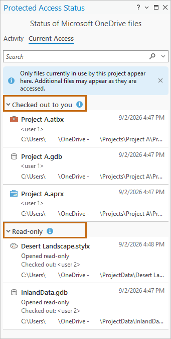
On the Current Access tab, project items that are in use appear either as checked out to you or read-only. If the project file and its default items are checked out to you, they remain checked out as long as the project is open. When an item is checked in, it is removed from the Current Access tab. Read-only items are also removed if they become unavailable.
On the Activity tab, the status of project items is recorded as you interact with the software. Items appear with the following messages:
Checked out to you
 —The item is checked out to you.
Checked in
 —The item was checked out to you but is no longer in use.
Read-only
 —The item is checked out by another user or you are not signed in to your OneDrive account. Items may also be read-only for other reasons.
Unavailable
 —The item has edits that are not synced to OneDrive.
Error
 —The item is unavailable for another reason.
The list of items on the Activity tab accumulates throughout your ArcGIS Pro session until you clear it. It can include items from multiple projects.
Follow these steps to use the Protected Access Status pane:
Open a OneDrive project or a project that contains protected OneDrive data.
On the ribbon, click the View tab. In the Windows group, click Protected Access
 .
The Protected Access Status pane appears.
On the Protected Access Status pane, click the Activity tab or the Current Access tab.
Optionally, on the Activity tab, use the following features:
Click Filter
 to filter the list of entries by item type and item status.
Type in the search box to find entries by a text string.
Click the menu button
 and click Clear to clear the list.
Optionally, on the Current Access tab, type in the search box to find entries by a text string.
Make a file geodatabase recovery copy
A protected file geodatabase may be checked out on a computer from which it can't be checked in. This can happen if the computer is lost or damaged, or if the only user with access to the computer is out of reach. In this situation, you can make a recovery copy of the file geodatabase to continue working with the data.
When you make a recovery copy, you have two options: you can copy the current geodatabase contents in the cloud, or you can copy the contents as they were before the current user checked out the geodatabase. Copying the cloud contents is the default option. It ensures that you are getting the latest synced changes; however, there is a chance that the geodatabase is an incomplete state. Optionally, you can copy both the current cloud contents and the pre-checkout contents.
File geodatabases are the only protected file type for which you can make a recovery copy.
Note:
OneDrive syncing must be enabled to make a recovery copy.
Follow these steps to create a recovery copy of a file geodatabase:
In the Catalog pane or a catalog view, browse to the geodatabase you want to copy. Click the icon
that represents its unavailable status.The Protected Access Status pane appears with the Activity tab selected. The unavailable geodatabase is at the top of the listed items.
On the Activity tab, click the Create Recovery Copy button
 and click Create Recovery Copy.
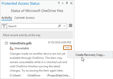
The Create Recovery Copy dialog box appears.
Accept the default option to copy the current cloud contents or click the option to copy the pre-checkout contents.
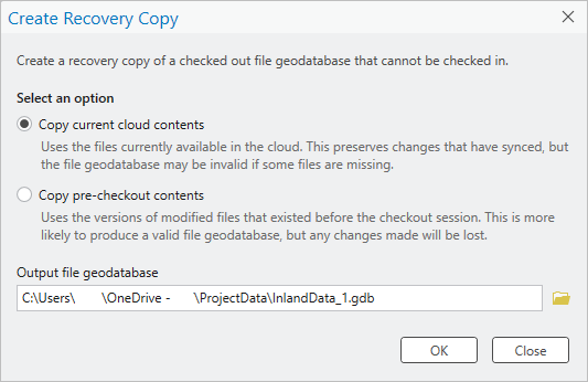
Optionally, change the default name of the file geodatabase or browse to a different output location.
If you use the name of the unavailable geodatabase, you must change the path. You cannot overwrite the unavailable geodatabase.
Click OK.
The recovery copy is made and a completion message appears on the dialog box. The dialog box remains open, giving you the opportunity to change the option and make another recovery copy.
Click Close.
You can now remove the unavailable geodatabase from the project and work with the copy.
Application shutdown recovery
If ArcGIS Pro shuts down unexpectedly, protected files of any type that are checked out to you are checked in automatically by ArcGIS Cleanup Utility, a background process that runs in Task Manager. When you restart ArcGIS Pro and open your project, these files are checked out to you again (unless they were checked out by another user in the meantime). As in any application shutdown, you may lose unsaved work. If you create backups automatically, you may get a project recovery prompt when you reopen the project.
Note:
If you are disconnected from the network when ArcGIS Pro shuts down, files are not checked in until you restore connectivity and restart ArcGIS Pro.
Loss of connectivity
If you lose network connectivity or OneDrive access while working with a project or protected data stored on OneDrive, any files that are checked out to you remain checked out until OneDrive access is restored. You can continue to work with these files in a read-only state; however, you cannot edit them, change their schema, or create new data from them.
While disconnected, you can add protected files to an open project, but the files are not checked out to you. You may be able to work with them in a read-only state.
If you exit ArcGIS Pro while a project is checked out to you, or if you open a different project, the Unable To Check In Files message appears.
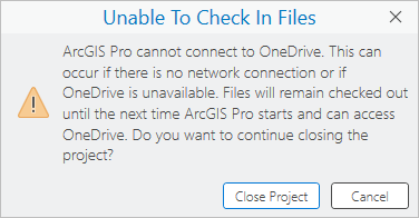
Click Close Project to continue the operation or click Cancel to leave the project open in an unsaved state.
If the loss of connectivity is beyond your control, you cannot check in files whether you close the project or keep it open. However, if you can restore connectivity, you should do so for long enough to close the project in a state that enables files to be checked in.
Status files
The process of checking out and checking in OneDrive items is managed by ArcGIS Pro through a status file associated with the item. For most items, the name of the status file consists of the item name followed by the item type and the extension .status, such as Project A_aprx.status or Landscape_stylx.status. For file geodatabases, it is a file named cloudStatus that is stored in the geodatabase folder.
Caution:
Do not modify or delete a protected OneDrive item's status file.
Limitations
The following limitations apply to working with projects and data on OneDrive. Additional limitations may be noted elsewhere in the documentation.
Sharepoint data
Data stored on SharePoint is supported only if a OneDrive shortcut is made to the SharePoint folder. This requires that the SharePoint data be stored in a folder.
Search
Data stored on OneDrive is not indexed by the ArcGIS Pro search index. This means that project searches do not return items stored on OneDrive.
Portal projects
Portal projects do not support using OneDrive files as default project items. Locations synced to OneDrive cannot be used as the home folder or the download location for portal projects.
Sync pausing
It is possible to interact with the OneDrive application through Windows operating system controls. If you work with shared OneDrive items, it is recommended that you not pause syncing as this may cause items to be unavailable to other users for extended periods.
Cautions
Follow these practices to avoid the risk of data loss or file corruption.
Do not add data from unprotected file types to projects used on OneDrive. See the list of protected file types.
Do not rename or delete folders that contain shared projects or shared protected files stored on OneDrive.
Do not use OneDrive datasets in stand-alone Python executables or Python scripts. File types that are protected in ArcGIS Pro are not protected in Python.